Gmina Kościelisko

Last updated
Gmina Kościelisko
Kościelisko Commune
Gmina
POL gmina Koscielisko COA.png
Coat of arms
Coordinates(Kościelisko): 49°17′27″N19°53′18″E / 49.29083°N 19.88833°E / 49.29083; 19.88833 Coordinates: 49°17′27″N19°53′18″E / 49.29083°N 19.88833°E / 49.29083; 19.88833
CountryFlag of Poland.svg  Poland
Voivodeship Lesser Poland
County Tatra
Seat Kościelisko
Area
  Total 136.37 km2 (52.65 sq mi)
Population (2006)
  Total 8,035
  Density 59/km2 (150/sq mi)
Website http://www.koscielisko.com.pl

Gmina Kościelisko is a rural gmina (administrative district) in Tatra County, Lesser Poland Voivodeship, in southern Poland, on the Slovak border. Its seat is the village of Kościelisko, which lies approximately 5 kilometres (3 mi) west of Zakopane and 86 km (53 mi) south of the regional capital Kraków.

Gmina administrative division of Poland

The gmina is the principal unit of the administrative division of Poland, similar to a municipality. As of 2010 there were 2,478 gminy throughout the country. The word gmina derives from the German word Gemeinde, meaning "community".

Tatra County County in Lesser Poland, Poland

Tatra County is a unit of territorial administration and local government (powiat) in Lesser Poland Voivodeship, southern Poland, on the Slovak border. It came into being on January 1, 1999, as a result of the Polish local government reforms passed in 1998. Its administrative seat and only town is Zakopane, which lies 85 kilometres (53 mi) south of the regional capital Kraków. The county takes its name from the Tatra mountain range, which covers most of its territory.

Lesser Poland Voivodeship Voivodeship in Poland

Lesser Poland Voivodeship or Lesser Poland Province, also known as Małopolska Voivodeship or Małopolska Province, is a voivodeship (province), in southern Poland. It has an area of 15,108 square kilometres (5,833 sq mi), and a population of 3,267,731 (2006).

Contents

The gmina covers an area of 136.37 square kilometres (52.7 sq mi), and as of 2006 its total population is 8,035.

Villages

The gmina contains the villages of Dzianisz, Kościelisko and Witów.

Dzianisz Village in Lesser Poland, Poland

Dzianisz is a village in the administrative district of Gmina Kościelisko, within Tatra County, Lesser Poland Voivodeship, in southern Poland, close to the border with Slovakia. It lies approximately 5 kilometres (3 mi) north of Kościelisko, 7 km (4 mi) north-west of Zakopane, and 82 km (51 mi) south of the regional capital Kraków.

Kościelisko Village in Lesser Poland, Poland

Kościelisko is a village in Tatra County, Lesser Poland Voivodeship, in southern Poland, close to the border with Slovakia. It is the seat of the gmina called Gmina Kościelisko. It lies approximately 5 kilometres (3 mi) west of Zakopane and 86 km (53 mi) south of the regional capital Kraków.

Witów, Tatra County Village in Lesser Poland, Poland

Witów is a village in the administrative district of Gmina Kościelisko, within Tatra County, Lesser Poland Voivodeship, in southern Poland, close to the border with Slovakia.

Neighbouring gminas

Gmina Kościelisko is bordered by the town of Zakopane and by the gminas of Czarny Dunajec and Poronin. It also borders Slovakia.

Zakopane Place in Lesser Poland, Poland

Zakopane is a town in the extreme south of Poland, in the southern part of the Podhale region at the foot of the Tatra Mountains. From 1975 to 1998 it was part of Nowy Sącz Province; since 1999 it has been part of Lesser Poland Province. As of 2016 its population was 27,424.

Gmina Czarny Dunajec is a rural gmina in Nowy Targ County, Lesser Poland Voivodeship, in southern Poland, on the Slovak border. Its seat is the village of Czarny Dunajec, which lies approximately 13 kilometres (8 mi) west of Nowy Targ and 70 km (43 mi) south of the regional capital Kraków.

Gmina Poronin is a rural gmina in Tatra County, Lesser Poland Voivodeship, in southern Poland. Its seat is the village of Poronin, which lies approximately 7 kilometres (4 mi) north-east of Zakopane and 80 km (50 mi) south of the regional capital Kraków.

Related Research Articles

Gmina Sękowa is a rural gmina in Gorlice County, Lesser Poland Voivodeship, in southern Poland, on the Slovak border. Its seat is the village of Sękowa, which lies approximately 7 kilometres (4 mi) south-east of Gorlice and 105 km (65 mi) south-east of the regional capital Kraków.

Gmina Uście Gorlickie is a rural gmina in Gorlice County, Lesser Poland Voivodeship, in southern Poland, on the Slovak border. Its seat is the village of Uście Gorlickie, which lies approximately 15 kilometres (9 mi) south of Gorlice and 106 km (66 mi) south-east of the regional capital Kraków.

Gmina Muszyna is an urban-rural gmina in Nowy Sącz County, Lesser Poland Voivodeship, in southern Poland, on the Slovak border. Its seat is the town of Muszyna, which lies approximately 33 kilometres (21 mi) south-east of Nowy Sącz and 105 km (65 mi) south-east of the regional capital Kraków.

Gmina Czorsztyn is a rural gmina in Nowy Targ County, Lesser Poland Voivodeship, in southern Poland, on the Slovak border. It takes its name from the village of Czorsztyn, its former seat. The present seat of the gmina is Maniowy, which lies approximately 19 kilometres (12 mi) east of Nowy Targ and 71 km (44 mi) south of the regional capital Kraków.

Gmina Jabłonka is a rural gmina in Nowy Targ County, Lesser Poland Voivodeship, in southern Poland, on the Slovak border. Its seat is the village of Jabłonka, which lies approximately 24 kilometres (15 mi) west of Nowy Targ and 67 km (42 mi) south of the regional capital Kraków.

Gmina Krościenko nad Dunajcem is a rural gmina in Nowy Targ County, Lesser Poland Voivodeship, in southern Poland, on the Slovak border. Its seat is the village of Krościenko nad Dunajcem, which lies approximately 30 kilometres (19 mi) east of Nowy Targ and 78 km (48 mi) south-east of the regional capital Kraków.

Gmina Lipnica Wielka is a rural gmina in Nowy Targ County, Lesser Poland Voivodeship, in southern Poland, on the Slovak border. Its seat is the village of Lipnica Wielka, which lies approximately 29 kilometres (18 mi) west of Nowy Targ and 69 km (43 mi) south of the regional capital Kraków. It also contains the village of Kiczory.

Gmina Zawoja is a rural gmina in Sucha County, Lesser Poland Voivodeship, in southern Poland, on the Slovak border. Its seat is the village of Zawoja, which lies approximately 9 kilometres (6 mi) south of Sucha Beskidzka and 52 km (32 mi) south-west of the regional capital Kraków. The gmina also contains the village of Skawica.

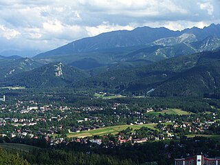
Gmina Biały Dunajec is a rural gmina in Tatra County, Lesser Poland Voivodeship, in southern Poland. Its seat is the village of Biały Dunajec, which lies approximately 10 kilometres (6 mi) north-east of Zakopane and 77 km (48 mi) south of the regional capital Kraków.

Gmina Bukowina Tatrzańska Gmina in Lesser Poland, Poland

Gmina Bukowina Tatrzańska is a rural gmina in Tatra County, Lesser Poland Voivodeship, in southern Poland, on the Slovak border. Its seat is the village of Bukowina Tatrzańska, which lies approximately 14 kilometres (9 mi) north-east of Zakopane and 80 km (50 mi) south of the regional capital Kraków.

Gmina Rajcza Gmina in Silesian, Poland

Gmina Rajcza is a rural gmina in Żywiec County, Silesian Voivodeship, in southern Poland, on the Slovak border. Its seat is the village of Rajcza, which lies approximately 22 kilometres (14 mi) south of Żywiec and 83 km (52 mi) south of the regional capital Katowice.

Bukowina Tatrzańska Village in Lesser Poland, Poland

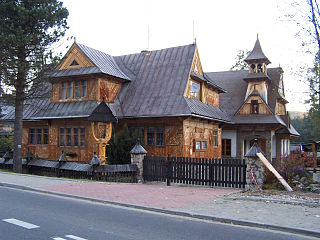
Bukowina Tatrzańska, is a village in Tatra County, Lesser Poland Voivodeship, in southern Poland, close to the border with Slovakia. It is the seat of the gmina called Gmina Bukowina Tatrzańska. It lies approximately 14 kilometres (9 mi) north-east of Zakopane and 80 km (50 mi) south of the regional capital Kraków.

Czarna Góra, Lesser Poland Voivodeship Village in Lesser Poland, Poland

Czarna Góra, is a village in the administrative district of Gmina Bukowina Tatrzańska, within Tatra County, Lesser Poland Voivodeship, in southern Poland, close to the border with Slovakia. It lies approximately 5 kilometres (3 mi) north of Bukowina Tatrzańska, 17 km (11 mi) north-east of Zakopane, and 77 km (48 mi) south of the regional capital Kraków.

Groń, Tatra County Village in Lesser Poland, Poland

Groń is a village in the administrative district of Gmina Bukowina Tatrzańska, within Tatra County, Lesser Poland Voivodeship, in southern Poland, close to the border with Slovakia. It lies approximately 7 kilometres (4 mi) north-west of Bukowina Tatrzańska, 13 km (8 mi) north-east of Zakopane, and 75 km (47 mi) south of the regional capital Kraków.

References