
Modes of transport in Mozambique include rail, road, water, and air. There are rail links serving principal cities and connecting the country with Malawi, Zimbabwe and South Africa. There are over 30,000km of roads, but much of the network is unpaved.

Maputo is the capital, and largest city of Mozambique. Located near the southern end of the country, it is within 120 kilometres of the borders with Eswatini and South Africa. The city has a population of 1,088,449 distributed over a land area of 347.69 km2 (134.24 sq mi). The Maputo metropolitan area includes the neighbouring city of Matola, and has a total population of 2,717,437. Maputo is a port city, with an economy centered on commerce. It is also noted for its vibrant cultural scene and distinctive, eclectic architecture. Maputo was formerly named Lourenço Marques until 1976.

Mbabane is a city in Eswatini, and is one of the two capitals, serving as the executive capital.
The Lubombo Transfrontier Conservation Area was born out of the Peace Park Foundation’s vision to establish a network of transfrontier conservation areas in southern Africa. It straddles the border between South Africa’s KwaZulu-Natal province, southern Mozambique, and Eswatini.

Komatipoort is a town situated at the confluence of the Crocodile and Komati Rivers in Mpumalanga province, South Africa. The town is 8 km from the Crocodile Bridge Gate into the Kruger National Park, just 5 km from the Mozambique border and 65 km from the Eswatini border.
Matola is the largest suburb of the Mozambique capital, Maputo, adjacent to its westernmost side. It is the nation's most populated city. Matola is the capital of Maputo Province and has had its own elected municipal government since 1998. It has a port and also the biggest industrial area in Mozambique. The population of Matola was, according to the 2007 census, 671,556 inhabitants, having increased to a 2017 census population of 1,032,197.
Articles related to Mozambique include:
Siphofaneni is a town in the Lubombo Region of central Eswatini (Swaziland), 45 kilometres from Manzini and 20 kilometres from Big Bend, a major sugarcane-producing town on the main highway leading to Durban. It has a tropical climate, very hot during summer and cold in winter. Malaria is endemic in Lubombo. Siphofaneni has hot springs and is surrounded by several sugarcane farms. It is located on the banks of the largest river in Swaziland, the Usutu.
Eswatini Railways (ESR), formerly known as Swaziland Railway or Swazi Rail, is the national railway corporation of Eswatini.

Portos e Caminhos de Ferro de Moçambique is a state-owned company that oversees the railway system of Mozambique and its connected ports.

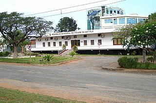
Boane District is a district of Maputo Province in southern Mozambique. The principal town is Boane. The district is located in the center of the province, and borders with Moamba District in the north, the city of Matola in the northeast, Matutuíne District in the south, and with Namaacha District in the west. In the east, it is bounded by the Indian Ocean. The area of the district is 815 square kilometres (315 sq mi). It has a population of 98,964 as of 2007.
Railway stations in Mozambique include:
Matsapha is a town in central Eswatini. The Matsapha urban boundary is defined in the Urban Government Act of 1969, as amended in 2012, and covers an area of approximately 2,000 hectares. Matsapha was established as an industrial park in 1965 and was officially gazetted as an urban area in 1969. Matsapha is located in the Upper Middleveld of Eswatini in the Manzini region, which is in the centre of the country. Matsapha is 11 km (7 mi) from the city of Manzini, the country's commercial capital, and 35 km (22 mi) from Mbabane, the administrative capital of the country. It is well located as it is on Eswatini's main east–west axis between South Africa and Mozambique, 16 km (10 mi) from the junction of the Lavumisa road that leads to Durban and KwaZulu Natal. It lies at an altitude of 625 m (2,051 ft) above sea level.

Salamanga is a town in southern Mozambique.
The Port of Maputo, also called the Maputo-Matola port complex, is a Mozambican port located in the cities of Maputo and Matola. They are installed in Maputo Bay, on the north bank of the Espírito Santo estuary, which is separated from the Mozambique Channel by the islands of Inhaca and Portugueses and by the Machangulo peninsula.

The border between Mozambique and South Africa is divided into two segments, separated by the kingdom of Eswatini. The northern segment, which is 410 kilometres (255 mi) long, runs north–south along the Lebombo Mountains from Zimbabwe to Eswatini. The southern segment, which is 81 kilometres (50 mi) long, runs east–west across Maputaland from Eswatini to the Indian Ocean.
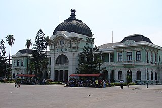
The Central Railway Station is a historic train station in Maputo, Mozambique. Administered by Mozambique Ports and Railways, it is located on the CFM Sul line, which links to South Africa, Eswatini, and Zimbabwe. It was constructed from 1908 to 1916 in the Beaux-Arts style. Widely recognized for its attractiveness, the station has been ranked by international publications as one of the world's most beautiful.

Pretoria–Maputo railway, also called Delagoa Bay railway, Iron railway and Eastern railway, is a railway that connects the city of Maputo, Mozambique, to the city of Pretoria, in South Africa. It is 567 km long, in 1067 mm gauge. The Mozambican section, between Maputo and Ressano Garcia, is managed by the state-owned Mozambique Ports and Railways (CFM) company, and it is officially known in Mozambique as the Ressano Garcia Line; in turn, on the South African stretch, between the town of Komatipoort and city of Pretoria, the administration is done by the company Transnet Freight Rail.

Goba railway, also called Swaziland-Maputo railway and Matsapha-Maputo railway, is a railway that connects the city of Maputo, Mozambique, to the city from Matsapha, in Eswatini. It is 466.8 km long, in a 1067 mm gauge.

Limpopo Railway, also called Gweru-Maputo railway, is a railway that connects the city of Maputo, Mozambique, to the city from Somabhula, in Zimbabwe. It is 900 km long, in a 1067 mm gauge.
