Khammam is the city in Khammam district of the Indian state of Telangana. It is the fourth largest city in the state. It is the headquarters of the Khammam district and Khammam mandal also. It is located about 193 kilometres (120 mi) east of the state capital, Hyderabad, 61 kilometres (38 mi) from Suryapet, 120 kilometres (75 mi) from Warangal and also it is located about 121 kilometres (75 mi) North of the Andhra Pradesh state capital, Amaravathi. The river Munneru flows on the western side of the city. As of 2011 census of India, Khammam urban agglomeration has a population of 313,504. However, on 19 October 2012, the civic body of Khammam was upgraded to a municipal corporation. Post- upgradation to corporation, the population of Khammam was approximated to be 3,07,000. During 2014-2023 under BRS regime Khammam got a major changeover, roads expansion, Medical College, Engineering College, ITHub.

East Godavari is a district in the Coastal Andhra region of Andhra Pradesh, India. Its district headquarters is at Rajamahendravaram.

Coastal Andhra, also known as Kosta Andhra, is a geographic region in the Indian state of Andhra Pradesh, comprising the coastal districts of the state between the Eastern Ghats and the Bay of Bengal, from the northern border with Orissa to Rayalaseema in the south. It includes major cities such as Visakhapatnam and Vijayawada as well as the state capital Amaravati and is recognized for its fertile lands, rich cultural heritage, and economic importance. Coastal Andhra plays a significant role in the state's agricultural output, particularly in rice and tobacco production, supported by abundant water resources from the Godavari, Krishna, and Penna rivers.

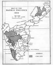
Rajahmundry, officially Rajamahendravaram, is a city in the Indian state of Andhra Pradesh and district headquarters of East Godavari district. It is the seventh most populated city in the state. During British rule, the district of Rajahmundry was created in the Madras Presidency in 1823. It was reorganised in 1859 and bifurcated into the Godavari and Krishna districts. Kakinada was the headquarters of Godavari district, which was further bifurcated into East Godavari and West Godavari districts in 1925. It is administered under Rajahmundry revenue division of the East Godavari district. The city is known for its floriculture, history, culture, agriculture, economy, tourism, and its heritage. It is known as the "Cultural Capital of Andhra Pradesh".

The West Godavari district is a coastal district in the Indian state of Andhra Pradesh with an administrative headquarters in Bhimavaram. As of the 2011 Census of India, the district has an area of 2,178 km2 (841 sq mi) and a population of 1,779,935. It is bounded by the Krishna district and Bay of Bengal to the south, East Godavari district to the east, and Eluru district, Kolleru Lake and Upputeru Drain to the northwest.

Kakinada is a port city and municipal corporation in the Indian state of Andhra Pradesh. Situated along the Bay of Bengal, it serves as the headquarters of Kakinada district and is a significant economic and cultural centre in the region. It is the sixth most populous city in the state and is recognised as one of the most liveable and cleanest cities in India among those with a population under one million. Nicknamed the "Pensioners' Paradise," Kakinada is known for its well-planned layout and modern infrastructure.

Eluru is a city and the district headquarters of Eluru district in the Indian state of Andhra Pradesh. It is one of the 14 municipal corporations in the state and the mandal headquarters of Eluru mandal in the Eluru revenue division. Situated on the banks of the Tammileru River, Eluru is strategically positioned in the southeastern part of Andhra Pradesh. It was historically known as Helapuri. As of 2011 Census of India, the city had a population of 214,414, where as Eluru Urban Development Authority has a population around 2,760,160, reflecting its status as a major urban centre. The city's historical significance dates back to the second century CE, with evidence of its ancient roots found in various archaeological sites and historical records. Eluru was a prominent town under the rule of the Qutub Shahis, who governed the region in the 16th century. It came under the control of the Mughal Empire in the 17th century as the empire expanded its influence across South India. The town later became part of the Nawab of Hyderabad's dominions in the 18th century. During British India, Eluru was incorporated into the Madras Presidency and made capital for Northern Circars in the early 19th century. The British established administrative and infrastructural developments in the town, shaping its modern identity.

Khammam district is a district in the eastern region of the Indian state of Telangana. The city of Khammam is the district headquarters. The district shares boundaries with Suryapet, Mahabubabad, Bhadradri districts and with Eluru and NTR districts.

Nidadavolu is a town in East Godavari district of the Indian state of Andhra Pradesh. It is a municipality and the mandal headquarters of Nidadavole mandal in Kovvur revenue division.

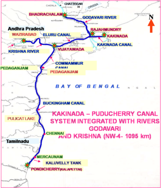
National Waterway 4 (NW-4) is a 1,095 kilometres (680 mi) long waterway in India. It has been declared as an Indian National Waterway and is currently under development. It connects the Indian states of Telangana, Andhra Pradesh, Tamil Nadu, and the union territory of Puducherry. The NW-4 runs along the Coromandal Coast through Kakinada, Eluru, Commanur, Buckingham Canals and also through part of Krishna and Godavari rivers in South India. It was declared a National Waterway on 24 November 2008 under the Provisions of National Waterways Bill, 2006. It is being developed by the Inland Waterways Authority of India (IWAI), and was scheduled for completion by 2013. The National Waterways Act, 2016 has extended the length of NW-4 from 1,095 km (680 mi) to 2,890 km (1,800 mi) by connecting the Krishna and Godavari Rivers. The Project would be undertaken in 3 phases with first phase beginning in October, 2017 and to be completed by June, 2019

The Polavaram Project is an under construction multi-purpose irrigation project on the Godavari River in the Eluru District and East Godavari District in Andhra Pradesh. The project has been accorded National project status by the Central Government of India. Its reservoir back water spreads up to the Dummugudem Anicut and approx 115 km on Sabari River side. Thus back water spreads into parts of Chhattisgarh and Odisha States. It gives major boost to tourism sector in Godavari Districts as the reservoir covers the famous Papikonda National Park, Polavaram hydro electric project (HEP) and National Waterway 4 are under construction on left side of the river. It is located 40 km to the upstream of Sir Arthur Cotton Barrage in Rajamahendravaram City and 25 km from Rajahmundry Airport.
Sayyadwada (Cheduvada) is a small Shia Muslims village in East Godavari district in the state of Andhra Pradesh, India. It is near the district headquarters Kakinada, about 25 km away. A Survey by Madras office in 1927 by Sri D.Venkatachalaayya Garu and LGB Firth included 'Cheduvada' in Cocanada Taluk. Cheduvada encompassed 330.00 acres and consisted of four ponds namely Mattakarra Cheruvu, Angulu Cheruvu, Ura Cheruvu and Pedda Cheruvu
South Coast Railway Zone (SCoR) has been announced as the newest railway zone of the Indian Railways and is headquartered at Visakhapatnam, Andhra Pradesh. The formal notification for operationalization of this Zone is yet to be issued.

Eluru district is a district in coastal Andhra Region in the Indian state of Andhra Pradesh. With Eluru as its administrative headquarters, it was proposed on 26 January 2022 to become one of the resultant twenty six districts in the state once a final notification is issued by the government of Andhra Pradesh. It is formed from Eluru revenue division and Jangareddygudem revenue division from West Godavari district and Nuzvid revenue division from Krishna district.

Kakinada district is a district in the Coastal Andhra Region in the Indian state of Andhra Pradesh. With Kakinada as its administrative headquarters, it was proposed on 26 January 2022 to become one of the resultant twenty six districts in the state after the final notification has been issued on 4 April 2022 by the government of Andhra Pradesh. The district was formed from Kakinada and Peddapuram revenue divisions from East Godavari district. Incidentally, during earlier times, the region comprising towns Pithapuram, Kakinada and Peddapuram were referred as Polnaud or Prolunadu, which now roughly corresponds to the areas in this district.
Rajahmundry Circar or Rajahmundry Sarkar was one of the five Northern Circars in the Golconda Sultanate, Deccan subah of Mughal empire and later in the Nizam's dominion of Hyderabad. The Northern Circars were the most prominent ones in the Deccan subah. Eastern Ghats near Pentakota village were considered the northern limit of the Rajahmundry Circar while the southern limit was demarcated by the Godavari river.
East Godavari, retrospectively referred to as United East Godavari, and Undivided East Godavari, was a district in the Coastal Andhra region of Andhra Pradesh, India. The district headquarters was located in Kakinada. It was the most populous district in Andhra Pradesh, with a population of 5,154,296 as per the 2011 Census. Kakinada and Rajahmundry were the major cities of the district.


