The Alps are the highest and most extensive mountain range system that lies entirely in Europe, separating Southern from Central and Western Europe and stretching approximately 1,200 kilometres (750 mi) across eight Alpine countries : France, Switzerland, Italy, Monaco, Liechtenstein, Austria, Germany, and Slovenia. The mountains were formed over tens of millions of years as the African and Eurasian tectonic plates collided. Extreme shortening caused by the event resulted in marine sedimentary rocks rising by thrusting and folding into high mountain peaks such as Mont Blanc and the Matterhorn. Mont Blanc spans the French–Italian border, and at 4,810 m (15,781 ft) is the highest mountain in the Alps. The Alpine region area contains about a hundred peaks higher than 4,000 metres (13,000 ft).
The Julian Alps are a mountain range of the Southern Limestone Alps that stretch from northeastern Italy to Slovenia, where they rise to 2,864 m at Mount Triglav, the highest peak in Slovenia and of the former Yugoslavia. They are named after Julius Caesar, who founded the municipium of Cividale del Friuli at the foot of the mountains. A large part of the Julian Alps is included in Triglav National Park. The second highest peak of the range, the 2,775 m high Jôf di Montasio, lies in Italy.

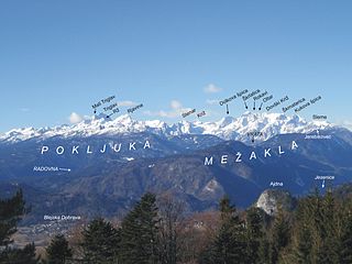
The Karawanks or Karavankas or Karavanks are a mountain range of the Southern Limestone Alps on the border between Slovenia to the south and Austria to the north. With a total length of 120 kilometres (75 mi) in an east-west direction, the Karawanks chain is one of the longest ranges in Europe. It is traversed by important trade routes and has a great tourist significance. Geographically and geologically, it is divided into the higher Western Karawanks and the lower-lying Eastern Karawanks. It is traversed by the Periadriatic Seam, separating the Apulian tectonic plate from the Eurasian Plate.
The Kamnik–Savinja Alps are a mountain range of the Southern Limestone Alps. They lie in northern Slovenia, except for the northernmost part, which lies in Austria.
The central and eastern Alps of Europe are rich in folklore traditions dating back to pre-Christian times, with surviving elements originating from Germanic, Gaulish (Gallo-Roman), Slavic (Carantanian) and Raetian culture.

The Alps cover a large area. This article describes the delimitation of the Alps as a whole and of subdivisions of the range, follows the course of the main chain of the Alps and discusses the lakes and glaciers found in the region.

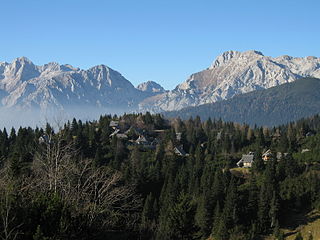
Seeberg Saddle, also just Seeberg (Jezersko) is a high mountain pass connecting Bad Eisenkappel in the Austrian state of Carinthia with Jezersko in the Slovenian region of Carinthia. It is located in the Southern Limestone Alps, between the Karavanke range in the west and the Kamnik–Savinja Alps in the east.

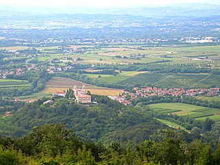
Resia is a comune (municipality) in the Province of Udine, in the Friuli-Venezia Giulia region of northern Italy.

The Soboth Pass is a high mountain pass in the Alps, located north of the border between Austria and Slovenia in the Austrian states of Styria and Carinthia connecting Soboth and Lavamünd.
The Wurzen Pass is a mountain pass in a col of the Karawanks mountain range in the Southern Limestone Alps, on the border between Radendorf in the Austrian state of Carinthia and Kranjska Gora in Slovenia. It is named after the nearby village of Podkoren (Wurzen).

Podlom is a small settlement in the Municipality of Kamnik in the Upper Carniola region of Slovenia. It lies in the Kamnik Alps, just under the Črnivec Pass.

SOIUSA is a proposal for a new classification system of the Alps from the geographic and toponomastic point of view. It was designed by Sergio Marazzi, Italian researcher and author of the Orographic Atlas of the Alps SOIUSA. His book was presented with the patronage of the Italian Alpine Club on 23 Jan 2006, but has yet to receive any formal acceptance.
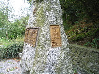
Colle di Cadibona - 436 m (1,430 ft) - is a mountain pass between Savona and Ceva in the Ligurian Alps, delineating the boundary with the Apennine Mountains. It is also known as Bocchetta di Altare. On the south-eastern side of the Alps Godovič Pass (Slovenia) conventionally represents the opposite end of the Alpine range.

The Municipality of Bovec is a municipality in northwestern Slovenia. Its center is the town of Bovec. As of June 2016, its mayor is Valter Mlekuž.
The Municipality of Kranjska Gora is a municipality on the Sava Dolinka River in the Upper Carniola region of northwest Slovenia, close to the Austrian and Italian borders. The seat of the municipality is the town of Kranjska Gora.

The Lavanttal Alps are part of the Central Eastern Alps in Austria and Slovenia, between the river Mur in the north and the Drava in the south.

The Alps Hockey League (AlpsHL) is a professional ice hockey league based in Central Europe. Currently, the league is made up of teams representing three nations: Austria, Italy and Slovenia, whilst a team from Croatia is also considering joining. The league formed as a result of a merger between Serie A and the Inter-National League.