
Balochistan is a province of Pakistan. Located in the southwestern region of the country, Balochistan is the largest province of Pakistan by land area but is the least populated one. It is bordered by the Pakistani provinces of Khyber Pakhtunkhwa to the north-east and Punjab to the east and Sindh to the south-east. It shares International borders with Iran to the west and Afghanistan to the north; It is also bound by the Arabian Sea to the south. Balochistan is an extensive plateau of rough terrain divided into basins by ranges of sufficient heights and ruggedness. It has the world's largest deep sea port, The Port of Gwadar lying in the Arabian Sea.

Makran, mentioned in some sources as Mecran and Mokrān, is the coastal region of Baluchistan. It is a semi-desert coastal strip in Balochistan, in Pakistan and Iran, along the coast of the Gulf of Oman. It extends westwards, from the Sonmiani Bay to the northwest of Karachi in the east, to the fringes of the region of Bashkardia/Bāšgerd in the southern part of the Sistān and Balučestān province of modern Iran. Makrān is thus bisected by the modern political boundary between Pakistan and Iran.

Gwadar is a port city with located on the southwestern coast of Balochistan, Pakistan. The city is located on the shores of the Arabian Sea opposite Oman. Gwadar is the 100th largest city of Pakistan, according to the 2017 census. It was an overseas possession of Oman from 1783 to 1958. It is about 120 km (75 mi) southwest of Turbat, while the sister port city of Chabahar in Iran's Sistan and Baluchestan province is about 170 km (110 mi) to the west of Gwadar. On 2 April 2021, Gwadar was declared the capital of the South Balochistan region.
Pasni, is a city and a fishing port in Gwadar District, Balochistan, Pakistan. It is located on the Makran coast on Arabian Sea about 450 km (280 mi) from Karachi. Administratively, Pasni is the headquarters of Pasni Tehsil, the sub-division of Gwadar District. Astola Island lies 40 km (25 mi) ESE of Pasni, in the Arabian Sea. The city of Pasni is itself administratively subdivided into two Union Councils.

Turbat is a city in southern Balochistan, Pakistan, and the administrative centre of Kech District. Situated on the Kech River Turbat was the historical capital of the State of Makran. Turbat is the second-largest city in Balochistan after Quetta and 38th largest city of Pakistan. It is the largest city in the southern part of the province. The Gwadar Port is about 180 kilometres (110 mi) to the southwest of Turbat.

The Khanate of Kalat was a Khanate that existed from 1512 to 1955 in the centre of the modern-day province of Balochistan, Pakistan. Prior to that they were subjects of Mughal King Akbar. Mehrab Khan II Ahmedzai ruled the state independently until 1839, when he was killed by the British and Kalat became a self-governing state in a subsidiary alliance with British India. After the signature of the Treaty of Kalat by the Khan of Kalat and the Baloch Sardars in 1875, the supervision of Kalat was the task of the Baluchistan Agency. Kalat was briefly independent again from 12 August 1947 until 27 March 1948, when its ruler Ahmad Yar Khan acceded to Pakistan, making it one of the Princely states of Pakistan.
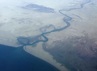
The Dasht River is located in the Makran region and Gwadar District, in the southwestern section of Balochistan Province, Pakistan which drains near Jiwani.
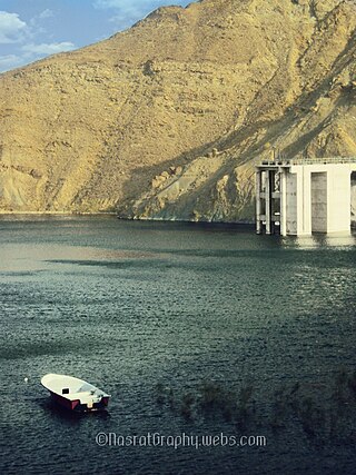
Miraani Dam. Dasht River south of the Central Makran Range in Kech District in Balochistan province of Pakistan. Its 302,000 acre-feet (373,000,000 m3) reservoir is fed by the Kech River and the Nihing River. Mirani Dam was completed in July 2006 and began impounding the Dasht River in August 2006.
The Balochistan Liberation Army, also known as the Baloch Liberation Army, is a Baloch ethnonationalist militant organization based in Afghanistan. The BLA's first recorded activity was during the summer of 2000, after it claimed credit for a series of bombing attacks on Pakistani authorities. The BLA is listed as a terrorist organization by Pakistan, the United Kingdom and the United States.
The Balochistan Liberation Front is a militant group operating in the Balochistan region of southwestern Asia. The group was founded by Jumma Khan in 1964 in Damascus, and played an important role in the 1968–1973 insurgency in Sistan and Baluchestan province of Iran and 1973–1977 insurgency in Balochistan province of Pakistan. However, the group's insurgency was defeated in both Pakistan and Iran and the status of the group became unknown until 2004. The group re-emerged in 2004 after Allah Nazar Baloch took command of the group in 2003. Since then the group has taken responsibility for attacks on civilians, journalists, government officials and military personnel.
Kalmati or Qarmati, Qarmatian, Karmati, Kalmat is a Baloch clan settled in the Balochistan and Sindh provinces of Pakistan. They are part of the Hoth Hoth Tribe, claiming descent from King Hoth, a son of Jalal Khan. When the Hoths were ruling Kech Makran, a few members of the tribe settled in Kalmat, near the port of Pasni, in the coastal area of Balochistan. In the 12th century, the Kalmati had spread from Tehs Bandar in the western part of Balochistan to Shah Bandar in Sindh. Today, the Kalmati tribes live throughout the districts and towns of Balochistan and Sindh.
The Kech River flows in the Makran region, of southeastern Iran and the southwestern area of Balochistan Province in southwestern Pakistan.
The Anglo-Marri Wars is the name given to three major military conflicts between the Marri Baloch tribesmen and the British Empire in the independent eastern Baloch tribal belt. The conflicts took place in the 19th and 20th centuries, specifically in 1840, 1880, and 1917.
Ghulam Mohammed Baloch was a Baloch nationalist politician. At the time of his assassination in 2009, he was serving as the president of the Baloch National Movement, as well as the General Secretary of the newly formed Baloch National Front. He had earlier served as a chairman of the Baloch Students Organization. His dead body was discovered on 9 April 2009, five days after being detained by gunmen who were believed to be Pakistani Law enforcement officers. The killing led to riots around Balochistan. He had been detained several times in the past by Pakistani intelligence agencies due to his political activities.
Parom is a Tehsil in Panjgur District in Balochistan, Pakistan. The historical area of Parom was divided by the Goldsmith line, thus a small part of it falls in Iranian territory. According to local legend, it was also known as Gulshan, meaning 'rose garden'. The word parom means 'growth' in the Balochi language and is attributed to Parom due to its mild climate and the fertile soil which supports more than one crop per year. Today the region has two union councils, Parom and Koh Bun. The population numbers around 50,000 people.

The M-8 is an east–west motorway in Pakistan, connecting Sukkur- Larkana to Gwadar. The motorway partly currently under-construction, while the 193 kilometer stretch between Gwadar and Hoshab was inaugurated in February 2016. A timeline for the completion of the motorway is not available due to the difficult terrain in which the motorway is being constructed.
The 1898 Baloch uprising was a revolt that occurred in Balochistan, modern-day Pakistan. It was instigated by Sardar Mehrab Khan Gichki and Mir Baloch Khan Nousherwani.
The economy of Balochistan, one of the four provinces of Pakistan, is largely based upon the production of natural gas, coal, and minerals. Agriculture and livestock also dominate the Baloch economy. Horticultural development is a fairly recent, yet growing phenomenon. Other important economic sectors include fisheries, mining, manufacturing industries, trade and other services being rendered by public and private sector organizations in the province.
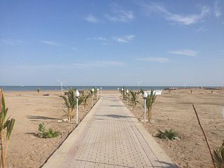
Tourism in Balochistan is a developing industry, and is overseen by the Tourism Directorate under the Government of Balochistan. Balochistan is known for its long coastal belt which extends from Karachi through Sonmiani, Ormara, Kalmat, Pasni, Gwadar, Jiwani and all the way up to Iran. It is also popular for its hill tops and rugged mountainous terrain.