Other uses
- Friends of Gold Butte, a non-profit organization
Gold Butte is a place name commonly used in Nevada.
Gold Butte may also refer to:

Gunnison is a home rule municipality that is the county seat and the most populous municipality of Gunnison County, Colorado. The city population was 6,560 at the 2020 United States Census. Gunnison was named in honor of John W. Gunnison, a United States Army officer who surveyed for a transcontinental railroad in 1853.

The Southwestern United States, also known as the American Southwest or simply the Southwest, is a geographic and cultural region of the United States that includes Arizona and New Mexico, along with adjacent portions of California, Colorado, Nevada, Oklahoma, Texas, and Utah. The largest cities by metropolitan area are Phoenix, Las Vegas, El Paso, Albuquerque, and Tucson. Before 1848, in the historical region of Santa Fe de Nuevo México as well as parts of Alta California and Coahuila y Tejas, settlement was almost non-existent outside of Nuevo México's Pueblos and Spanish or Mexican municipalities. Much of the area had been a part of New Spain and Mexico until the United States acquired the area through the Treaty of Guadalupe Hidalgo in 1848 and the smaller Gadsden Purchase in 1854.

The Western United States is the region comprising the westernmost U.S. states. As American settlement in the U.S. expanded westward, the meaning of the term the West changed. Before around 1800, the crest of the Appalachian Mountains was seen as the western frontier. The frontier moved westward and eventually the lands west of the Mississippi River were considered the West.

The Colorado River is one of the principal rivers in the Southwestern United States and in northern Mexico. The 1,450-mile-long (2,330 km) river drains an expansive, arid watershed that encompasses parts of seven U.S. states and two Mexican states. The name Colorado derives from the Spanish language for "colored reddish" due to its heavy silt load. Starting in the central Rocky Mountains of Colorado, it flows generally southwest across the Colorado Plateau and through the Grand Canyon before reaching Lake Mead on the Arizona–Nevada border, where it turns south toward the international border. After entering Mexico, the Colorado approaches the mostly dry Colorado River Delta at the tip of the Gulf of California between Baja California and Sonora.

Lake Mead is a reservoir formed by Hoover Dam on the Colorado River in the Southwestern United States. It is located in the states of Nevada and Arizona, 24 mi (39 km) east of Las Vegas. It is the largest reservoir in the US in terms of water capacity. Lake Mead provides water to the states of Arizona, California, and Nevada as well as some of Mexico, providing sustenance to nearly 20 million people and large areas of farmland.

The Gold Country is a historic region in the northern portion of the U.S. state of California, that is primarily on the western slope of the Sierra Nevada. It is famed for the mineral deposits and gold mines that attracted waves of immigrants, known as the 49ers, during the 1849 California Gold Rush.

The Shasta Cascade region of California is located in the northeastern and north-central sections of the state bordering Oregon and Nevada, including far northern parts of the Central Valley and the Sierra Nevada mountain range.

The Virgin River is a tributary of the Colorado River in the U.S. states of Utah, Nevada, and Arizona. The river is about 162 miles (261 km) long. It was designated Utah's first wild and scenic river in 2009, during the centennial celebration of Zion National Park.

The Indigenous peoples of the Great Basin are Native Americans of the northern Great Basin, Snake River Plain, and upper Colorado River basin. The "Great Basin" is a cultural classification of indigenous peoples of the Americas and a cultural region located between the Rocky Mountains and the Sierra Nevada, in what is now Nevada, and parts of Oregon, California, Idaho, Wyoming, and Utah. The Great Basin region at the time of European contact was ~400,000 sq mi (1,000,000 km2). There is very little precipitation in the Great Basin area which affects the lifestyles and cultures of the inhabitants.
A virgin is a person who has not engaged in sexual intercourse.

Plumas National Forest is a 1,146,000-acre (4,640 km2) United States National Forest located at the northern terminus of the Sierra Nevada, in northern California. The Forest was named after its primary watershed, the Rio de las Plumas, or Feather River.
Table Mountain is a large flat-topped mountain overlooking Cape Town, South Africa.
Wild horse is a species of the genus Equus that includes domesticated and undomesticated subspecies.
Black Butte may refer to:

The Muav Limestone is a Cambrian geologic formation within the 5-member Tonto Group. It is a thin-bedded, gray, medium to fine-grained, mottled dolomite; coarse- to medium-grained, grayish-white, sandy dolomite and grayish-white, mottled, fine-grained limestone. It also contains beds of shale and intraformational conglomerate. The beds of the Muav Limestone are either structureless or exhibit horizontally laminations and cross-stratification. The Muav Limestone forms cliffs or small ledges that weather a dark gray or rusty-orange color. These cliffs or small ledges directly overlie the sloping surfaces of the Bright Angel Shale. The thickness of this formation decreases eastward from 250 feet (76 m) in the western Grand Canyon to 45 feet (14 m) in the eastern Grand Canyon. To the west in southern Nevada, its thickness increases to 830 feet (250 m) in the Frenchman Mountain region.
El Dorado is a mythical city of gold.

Gold Butte is the name of a ghost town and nearby mountain peak in Clark County, Nevada. Both are protected as part of the Gold Butte National Monument, managed by the Bureau of Land Management. Gold Butte, the mountain, is 5,013 feet (1,528 m) high and rises 1,280 feet (390 m) above the town of Gold Butte. This peak lies within the Virgin Mountains and its name apparently refers to the Gold Butte Mining District.

The Devonian Temple Butte Formation, also called Temple Butte Limestone, outcrops through most of the Grand Canyon of Arizona, USA; it also occurs in southeast Nevada. Within the eastern Grand Canyon, it consists of thin, discontinuous and relatively inconspicuous lenses that fill paleovalleys cut into the underlying Muav Limestone. Within these paleovalleys, it at most, is only about 100 feet (30 m) thick at its maximum. Within the central and western Grand Canyon, the exposures are continuous. However, they tend to merge with cliffs of the much thicker and overlying Redwall Limestone.

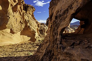
Gold Butte National Monument is a United States national monument located in Clark County, Nevada, northeast of Las Vegas and south of Mesquite and Bunkerville. The monument protects nearly 300,000 acres of desert landscapes featuring a wide array of natural and cultural resources, including rock art, sandstone towers, and important wildlife habitat for species including the Mojave Desert tortoise, bighorn sheep, and mountain lion. The area also protects historic ranching and mining sites such as the ghost town of Gold Butte, although little but mine openings, cement foundations, and a few pieces of rusting equipment remains. The monument is managed by the Bureau of Land Management.