Selebi-Phikwe is a mining town located in the Central District of Botswana. It had a population of 42,488 in 2022. The town is an administrative district, separate from the surrounding Central District.

Molepolole is a large village in Kweneng District, Botswana.

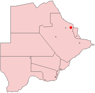
Francistown is the second-largest city in Botswana, with a population of about 103,417 and 147,122 inhabitants for its agglomeration at the 2022 census. It is located in eastern Botswana, about 400 kilometres (250 mi) north-northeast from the capital, Gaborone. Francistown is located at the confluence of the Tati and Ntshe rivers, and near the Shashe River and 90 kilometres (56 mi) from the international border with Zimbabwe.

Education in Botswana is provided by public schools and private schools. Education in Botswana is governed by the Ministries of Basic Education. and Tertiary, Research Science and Technology Among sub-Saharan African countries, Botswana has one of the highest literacy rates. According to The World Factbook - Central Intelligence Agency as of 2015, 88.5% of the population age 15 and over can read and write in Botswana were respectively literate.

Guntur district is one of the twenty six districts in the Coastal Andhra region of the Indian state of Andhra Pradesh. The administrative seat of the district is located at Guntur, the largest city of the district in terms of area and with a population of 670,073. It has a coastline of approximately 100 km (62 mi) on the right bank of Krishna River, that separates it from Krishna district and NTR district. It is bounded on the south by Bapatla district and on the west by Palnadu district. It has an area of 2,443 km2 (943 sq mi), with a population of 20,91,075, as per 2011 census of India.
Bobonong is a town in the Central District of Botswana 80 km from Selibe Phikwe town. Bobonong has a population of around 19,000. The Babirwa tribe can be found in this town. The Botswana Pink semi-precious stones can be found in Bobonong region. The Babirwa are known for harvesting the mophane worm. The locals refer to the town as Bobcity or formerly Lekgarapeng, which was derived from the stoney landscape of the town.
Letlhakane is an urban village in the Central District of Botswana.The village has a population of approximately 22’000 as at 2022 Population Census counting. Letlhakane serves as the headquarters of the Boteti sub-district council. It is considered the second most central village in Botswana after Serowe, connecting the upper Northern, Eastern areas as well as the Western areas of the country.

Thamaga is a large village located in the Kweneng District of Botswana and about 40 km west of the capital city Gaborone. It is home to 19,547 inhabitants at the 2011 census. It is becoming year by year like a suburb part of the Gaborone agglomeration.
Tutume is a large Bakalanga village located in the Tutume District of Botswana, about 50 km from the Zimbabwe border gate at Maitengwe. The nearest city is Francistown, about 100 km away. The village is a district headquarters and has a population of 23,000 .It is made up of wards: Sitabule(Madikwe),Tjilagwani(Selolwane), Thini and Madandume (Magapatona). In each ward there is a headman and his advisers in the kgotla. The main kgotla is located in Madikwe ward near Tutume Central Primary School. The village was named after the river "TUTUME", in Kalanga they will say "gwizi go Tutuma", meaning that the river was overflowing.

Churu is a district of the Indian state of Rajasthan in northern India.

Bhagabanpur I is a community development block that forms an administrative division in Egra subdivision of Purba Medinipur district in the Indian state of West Bengal.
Seronga is a village in North-West District, Botswana. It is located close to beginning of the Okavango Delta, and has a local airstrip. The population of Seronga was 1,641 in 2001 census. In 2011 population census, the village had a population of 3716 making it the fourth largest village in Ngamiland West. Seronga village has two government schools namely; Seronga Primary School and Ngambao Junior Secondary School. In addition, Seronga village has other government facilities namely Seronga Sub-Land Board, Seronga Police Station, Seronga Airfield, National Parks and Wildlife Office, Tribal Administration office headed by Senior Chief Representative, 24 hour Clinic with a Doctor.
Mathangwane is a village in the Central District of Botswana administered under Tutume Sub-district Council. The village is located at the confluence of the Shashe and Vukwi rivers, 25 kilometres west of the City of Francistown along the A3 highway and almost entirely on the left bank of Shashe River. The population of the village was 5,075 in the 2011 national population and housing census. The village is characterised by many river valleys, mostly tributaries to Shashe River and used for identifying the village community wards (dikgotlana) boundaries.
Otse is a village in the South-East District of Botswana. It is located 60 km south of Gaborone, along the Gaborone–Lobatse road and close to the border with South Africa. This village is home to the Balete people who are related to those in Ramotswa, Gabane and Mogobane. The population was 7,636 in 2011 census.
Letlhakeng or Lethakeng is an urban village in Kweneng District of Botswana. The village is located 75 km north-west of Molepolole. The population of Letlhakeng was 7,229 in the 2011 census.

Jangipara is a community development block that forms an administrative division in Srirampore subdivision of Hooghly district in the Indian state of West Bengal.
Lejwana, Botswana is a small village in the Republic of Botswana in Africa. It is situated in the Southern District of Botswana. It lies between the coordinates 25°24'23S and 25°32'27E. It is situated between the villages of Gathwane, Pitsane, Kgoro, and Digawana. Lejwana is about 30 km from Lobatse and about 100 km by road from the capital Gaborone.

Habra II is a community development block that forms an administrative division in Barasat Sadar subdivision of North 24 Parganas district in the Indian state of West Bengal.

Khejuri I is a community development block that forms an administrative division in Contai subdivision of Purba Medinipur district in the Indian state of West Bengal.
Molapowabojang is a village in the Southern District of Botswana, Located between Lobatse and Kanye, about 15 km North-West of Lobatse. With a population of about 7,520. This village falls under an administration of the Southern District Council which is headquartered in Kanye.
