
The main segment of the Los Gatos Creek Trail is a 9.7-mile (15.6 km) pedestrian and bicycle trail that runs through western Santa Clara County in California. It runs from Lexington Reservoir in Los Gatos, California through Campbell, California to Meridian Avenue in San Jose, California alongside Los Gatos Creek.

The Mount Vernon Trail (MVT) is an 18-mile (29 km) long shared use path that travels along the George Washington Memorial Parkway in Northern Virginia between Rosslyn and George Washington's home at Mount Vernon. The trail connects the easternmost portions of Arlington County, the City of Alexandria, and Fairfax County, and travels mostly on dedicated trail with a small portion on city streets. As part of U.S. Bike Route 1, the Potomac Heritage Trail and the East Coast Greenway, the MVT opened in April 1972 as a gravel path and was subsequently expanded and paved.

Cougar Mountain Regional Wildland Park is a regional park in King County, Washington, near the towns of Bellevue and Issaquah. The park was established in June 1983 to protect the central core of Cougar Mountain, the park covers 3,115 acres (12.61 km2) with 38 miles (61 km) of hiking trails and 12 miles (19 km) of equestrian trails.
The Washington, Baltimore and Annapolis Trail (WB&A) is a 10.25-mile (16.50 km) long discontinuous rail trail from Lanham to Odenton in Maryland. Despite its name, it does not actually connect with Washington, D.C., Annapolis or Baltimore; its name is taken from the Washington, Baltimore and Annapolis Electric Railway, from which the right-of-way comes. The trail exists in two separate pieces, one in Anne Arundel County and the other in Prince George's County, separated by the lack of a bridge over the Patuxent River. The bridge's construction and the trail's alignment was delayed for over a decade due to a property dispute; however, the trail was realigned and plans exist to complete a bridge by 2021. Additional plans exist to extend the trail southward to the Washington, D.C. border.

Withlacoochee State Trail is a 46-mile (74 km) long paved, multi-use, non-motorized rail trail in Florida located in Citrus, Hernando and Pasco counties. It follows along the Withlacoochee River and passes through the Withlacoochee State Forest. It is the longest paved rail trail in Florida.

Hop River State Park Trail is a Connecticut rail trail that winds for 20.8 miles (33.5 km) eastward from Colonial Drive in the town of Manchester to the Air Line State Park Trail S. in the town of Windham. The trail parallels the Hop River for much of its length. It is owned and operated by the Connecticut Department of Energy and Environmental Protection, with upgrades and maintenance done by town forces and community volunteer groups in coordination with the state. The trail is used for hiking, biking, horseback riding, and cross-country skiing.

The Schuylkill River Trail is a multi-use trail along the banks of the Schuylkill River in southeastern Pennsylvania. Partially complete as of 2018, the trail is ultimately planned to run about 140 miles (230 km) from the river's headwaters in Schuylkill County to Fort Mifflin in Philadelphia.
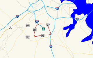
Airport Loop is the designation for the portions of state highways that form a circumferential highway around Baltimore/Washington International Thurgood Marshall Airport in Anne Arundel County in the U.S. state of Maryland. The loop runs 8.44 miles (13.58 km) through the communities of Linthicum, Ferndale, and Hanover. Airport Loop consists of a 3.47-mile (5.58 km) section of Maryland Route 170 (MD 170) along the western and northern sides of the loop; the entire 2.31-mile (3.72 km) length of MD 162 on the eastern side of the loop; and a 2.66-mile (4.28 km) segment of MD 176 on the southern side of the loop. Airport Loop intersects Interstate 195 (I-195), which provides freeway access to the airport terminal, and is connected to I-695, I-97, and MD 100 via connecting highways. The MD 170 and MD 162 sections of Airport Loop are part of the National Highway System.
The Guadalupe River Trail is an 11-mile (18 km) pedestrian and bicycle path in the city of San Jose, California. The path runs along the banks of the Guadalupe River. The trail is currently composed of two discontinuous segments: a shorter "upper" segment in the Almaden Valley neighborhood of San Jose and a longer "lower" segment through Downtown San Jose to Alviso. This trail is heavily used for both recreation and commuting, as it provides direct access to Downtown San Jose from many of the outlying neighborhoods. The trail is paved.

The Wiouwash State Trail is a rail trail in northeastern Wisconsin. Its name is derived from the first two letters of the four counties it traverses: Winnebago, Outagamie, Waupaca, and Shawano. The trail's Tribal Heritage Crossing of Lake Butte des Morts is a nationally designated recreation trail. The trail is used by walkers, hikers, bikers, horseback riders, and snowmobilers during the winter months. Two sections of the trail are complete: 24 miles from Aniwa south to Split Rock and 21 miles from Hortonville south to Oshkosh.

State Road 49 is the state designation for US 19/98/27 Alternate(SR 55) in Chiefland, and US 27(SR 20) in Hildreth east of Branford, Florida. It also includes a county extension in Suwannee County, Florida from Hildreth to the outskirts of Live Oak, Florida.

The Anacostia Tributary Trail System (ATTS) is a unified and signed system of stream valley trails joining trails along the Anacostia tributaries of Northwest Branch, Northeast Branch, Indian Creek and Paint Branch with a trail along the Anacostia River, set aside and maintained by the Maryland-National Capital Park and Planning Commission (M-NCPPC) in the Maryland suburbs of Washington, D.C.

The Rivergreenway is the backbone of burgeoning Fort Wayne Trails network in Fort Wayne, Indiana and the surrounding area. The Rivergreenway consists of 26-miles of connected trails through a linear park following alongside or near the City's three rivers: St. Joseph River, St. Marys River, and Maumee River. In 2009, the Rivergreenway was designated as a National Recreation Trail. The trail network also connects to the Wabash & Erie Canal Towpath Trail. Including other trails, like the scenic Pufferbelly Trail which spans Fort Wayne's north side and will eventually connect downtown Fort Wayne to the northern edge of Allen County and beyond, the City of Fort Wayne has over 101 miles of trails. 140 miles exist within Allen County.
The South Tar River Greenway is a 3.1 miles (5.0 km) greenway located in Greenville, North Carolina. The northwest terminus trailhead is located at the Town Common. The trail goes east and follows the southern bank of the Tar River, then at the confluence of the Tar River and Green Mill Run, turns south and follows the western edge of the tributary. The southeast terminus trailhead is located at Greensprings Park. This greenway is the second in the city, after the 1.5 miles (2.4 km) Green Mill Run Greenway. The $1,488,000 project is funded from the Federal Highway Administration budget through its inclusion in the Federal FY2005 Appropriations Act.

An extensive collection of parks and greenways exists in Huntsville, Alabama for the public's recreational use.

Jones Falls Trail is a hiking and bicycling trail in Baltimore, Maryland. It mostly runs along the length of the namesake Jones Falls, a major north–south stream in and north of the city that has long acted as a major transportation corridor for the city. It also incorporates the bike path encircling Druid Hill Reservoir and its namesake park. The Jones Falls Trail forms a segment of the East Coast Greenway, a partially completed network of off-road bicycling routes that runs the length of the East Coast.

Gywnns Falls Trail is a 15-mile (24 km) series of hiking and bicycling trails inside Baltimore, Maryland, named for the Gwynns Falls, whose course it follows, and the surrounding Gwynns Falls Leakin Park it passes through. The trail uses unique alignments, sidepaths on existing streets, and on-street sections. The trail consists of one 10.75-mile (17.30 km) mainline, plus a number of branches, including the Middle Branch Trail, the Hutton Trail, and the Dickeyville Trail. All of these trails carry signage designating them as the Gwynns Falls Trail; their individual names are designated on the mile markers designating their route. The entirety of the Middle Branch Trail, as well as the section of the mainline trail east of the Middle Branch Trail's northern terminus, are part of the East Coast Greenway.
The Loop is a network of shared-use paths in metropolitan Tucson, Arizona maintained by Pima County. Once complete it will comprise 131 miles (211 km) of paved trails dedicated to cyclist, pedestrian, and equestrian use. By 2014, the network was 85% complete, with over one hundred miles in place. Pima County estimates the Loop is used by an average of 2,000 visitors each weekday and more than 5,000 on weekends.

Hiawatha LRT Trail is a 4.7-mile (7.6 km), multi-use path adjacent to a light-rail transit line in Minneapolis, Minnesota, United States, that is popular with bicycle commuters. Users travel along the Metro Blue Line and Hiawatha Avenue transit corridor, reaching downtown Minneapolis near an indoor sports stadium at the trail’s northern end, and reaching a bridge above Minnehaha Creek at the trail’s southern end. Hiawatha LRT Trail provides a vital link between several Minneapolis neighborhoods and the city’s downtown area.

