
Grenada is a Caribbean island between the Caribbean Sea and Atlantic Ocean, north of Trinidad and Tobago. It is located at 12°07′N61°40′W. There are no large inland bodies of water on the island, which consists entirely of the state of Grenada. The coastline is 121 km long.

Carriacou and Petite Martinique is a dependency of Grenada, lying north of Grenada island and south of Saint Vincent and the Grenadines in the Lesser Antilles. The islands of Carriacou and Petite Martinique belong to the island of Grenada. Together they all form the 3 island country of Grenada Carricou and Petite Martinique.
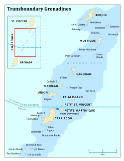
The Grenadines are a chain of small islands that lie on a line between the larger islands of Saint Vincent and Grenada in the Lesser Antilles. Nine are inhabited, including the mainland Saint Vincent and the Grenadines islands: Young Island, Bequia, Mustique, Canouan, Union Island, Mayreau, Petit St Vincent, and Palm Island. Prominent uninhabited islands of the Grenadines include Petit Nevis, used by whalers, and Petit Mustique, which was the center of a prominent real estate scam in the early 2000s.

Saint Patrick is one of the Catholic parishes of Grenada, covering the north of the country.

In the U.S. state of Oregon, U.S. Route 30, a major east–west U.S. Highway, runs from its western terminus in Astoria to the Idaho border east of Ontario. West of Portland, US 30 generally follows the southern shore of the Columbia River; east of Portland the highway has largely been replaced with Interstate 84, though it is signed all the way across the state, and diverges from the I-84 mainline in several towns, as a de facto business route. Out of all the states U.S. Route 30 traverses, it spends the most time in Oregon.

Saint John is one of the parishes of Grenada. Its capital is Gouyave. Fishing is the main industry. Gouyave is also the home of Grenada's biggest nutmeg factory and of the Dougladston Estate, an old spice plantation. There is almost no tourism in this parish of Grenada, with only a few small guesthouses such as the Mango Bay Cottages in Woodford.
The River Creedy is a small river in Devon, England. It gives its name to the local town or ton of Crediton, which is on its west bank, and to several local historic estates, namely Creedy Hilion, Creedy Peitevin and Creedy Park, in the parish of Sandford, also to the Benefice of North Creedy. Just below the town, the river merges with the River Yeo and it ends where it meets the River Exe at Cowley Bridge. The river is overlooked by Fordy Wood Copse, a 0.64 hectares woodland owned and managed by the Woodland Trust.

The River Mint is a river in Cumbria, England. The Mint starts life at Whelpside at the confluence of Bannisdale Beck, running south-east from Bannisdale Head, and a smaller stream draining a group of small valleys from headwaters in The Forest, Combs Hollow and Mabbin Crag.

Gouyave is the capital and largest town in the parish of St John, Grenada. It is located on the west coast of the Grenada.
Soledad Atzompa is a village in the mountainous central zone in the State of Veracruz, about 90 km south-east of the state capital Xalapa. It has an area of 65.80 km2 and stands at an elevation of 2260 metres above sea level
The Bon Accord River is a river of Grenada.
The Charlotte River is a river of Grenada. The Charlotte River is situated in the parish of St. John, in the town of Gouyave.
The Douce River is a river of Grenada.
The Great Palmiste River is a river of Grenada. It's in the west part of the country, 9 kilometers north of Saint George.
The Little Palmiste River is a river of Grenada.In the parish of st.John,it flows from the palmiste dig.The dig structure was built over 3 centuries ago during the french period of colonization of grenada.
The Tempé River is a river of Grenada.
State Highway 79 (SH 79) is a New Zealand state highway connecting the South Canterbury communities of Rangitata, Geraldine, and Fairlie. Starting at State Highway 1 the highway is 61 kilometres in length and runs in a general east-west direction. 6.3 km of the highway through Geraldine runs concurrently with the Inland Scenic Route, formerly State Highway 72. The road is a two-lane single carriageway, with a one-lane bridge crossing the Orari River.

Lauriston is a lightly populated locality in the Canterbury region of New Zealand's South Island. It is situated on the Canterbury Plains south of the Rakaia River, some 20 kilometres (12 mi) inland from Rakaia. It was named after one of its pioneer settlers with the name of Laurie.

Holes Bay is an intertidal embayment off Poole Harbour in the county of Dorset on the south coast of England. It lies mostly within the Borough of Poole and is close to Poole town centre. It is an important wetland bird haven.
National Cycle Route 61 is part of theNational Cycle Network managed by the charity Sustrans. It runs for 34 miles from Maidenhead (Berkshire) to Rye House (Hertfordshire) via Uxbridge, Watford, St Albans, Hatfield, Welwyn Garden City and Hertford in the United Kingdom.
