
Andhra Pradesh is a state in the south-eastern coastal region of India. It is the seventh-largest state by area covering an area of 162,975 km2 (62,925 sq mi) and tenth-most populous state with 49,386,799 inhabitants. It is bordered by Telangana to the north-west, Chhattisgarh to the north, Odisha to the north-east, Tamil Nadu to the south, Karnataka to the west and the Bay of Bengal to the east. It has the second longest coastline in India after Gujarat, of about 974 km (605 mi). Andhra Pradesh is the first state to be formed on a linguistic basis in India on 1 October 1953. The state was once a major Buddhist pilgrimage site in the country and a Buddhist learning center which can be seen in many sites in the state in the form of ruins, chaityas and stupas It is also known as the land of the world-famous diamond Koh-i-Noor and many other globally known diamonds due to their source in its Kollur Mine. It is also known as the "rice bowl of India" for being a major producer of rice in India. Its official language is Telugu; one of the classical languages of India, the fourth most spoken language in India and the 11th-most spoken language in the world.

Karnataka is the largest state in South India and sixth largest in India. The state is in the south western region of India. It was formed on 1 November 1956, with the passage of the States Reorganisation Act. Originally known as the State of Mysore, it was renamed Karnataka in 1973. The state corresponds to the Carnatic region. Its capital and largest city is Bangalore.

A municipality is usually a single administrative division having corporate status and powers of self-government or jurisdiction as granted by national and regional laws to which it is subordinate.

Maharashtra is a state in the western and central peninsular region of India occupying a substantial portion of the Deccan Plateau. The centre of India is in this state. Maharashtra is the second-most populous state in India as well as the third-most populous country subdivision in the world. It was formed on 1 May 1960 by splitting the bilingual Bombay State, which had existed since 1956, into majority Marathi-speaking Maharashtra and Gujarati-speaking Gujarat. Thus Maharashtra is a Marathi linguistic state. The state is divided into 6 divisions and 36 districts, with the state capital being Mumbai, also the most populous urban area in India and Nagpur serving as the winter capital. The Godavari and the Krishna are the two major rivers in the state. Marathi is the most widely spoken language and is also the official language of the state. The forest cover in the state is 16.47% of the state's geographical area. Out of total cultivable land in Maharashtra about 60% land is under food grain crops with Jowar being the dominating crop.
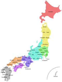
Japan is divided into 47 prefectures, which rank immediately below the national government and form the country's first level of jurisdiction and administrative division. They include 43 prefectures proper two urban prefectures, one "circuit" or "territory" and one metropolis. In 1868, the Meiji Fuhanken sanchisei administration created the first prefectures to replace the urban and rural administrators in the parts of the country previously controlled directly by the shogunate and a few territories of rebels/shogunate loyalists who had not submitted to the new government such as Aizu/Wakamatsu. In 1871, all remaining feudal domains (han) were also transformed into prefectures, so that prefectures subdivided the whole country. In several waves of territorial consolidation, today's 47 prefectures were formed by the turn of the century. In many instances, these are contiguous with the ancient ritsuryō provinces of Japan.

Washington, D.C., formally the District of Columbia and also known as D.C. or just Washington, is the capital city of the United States. It is located on the east bank of the Potomac River which forms its southwestern and southern border with Virginia, and shares a land border with Maryland on its remaining sides. The city was named for George Washington, the first president of the United States and a Founding Father, and the federal district is named after Columbia, a female personification of the nation. As the seat of the U.S. federal government and several international organizations, the city is an important world political capital. It is one of the most visited cities in the U.S., seeing over 20 million visitors in 2016.
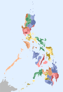
In the Philippines, provinces are one of its primary political and administrative divisions. There are 81 provinces at present, which are further subdivided into component cities and municipalities. The local government units in the National Capital Region, as well as independent cities, are independent of any provincial government. Each province is governed by an elected legislature called the Sangguniang Panlalawigan and an elected governor.

The federal government of the United States is the national government of the United States, a federal republic in North America, composed of 50 states, a federal district, five major self-governing territories and several island possessions. The federal government is composed of three distinct branches: legislative, executive, and judicial, whose powers are vested by the U.S. Constitution in the Congress, the president and the federal courts, respectively. The powers and duties of these branches are further defined by acts of Congress, including the creation of executive departments and courts inferior to the Supreme Court.

Uttar Pradesh is a state in northern India. With over 200 million inhabitants, it is the most populous state in India as well as the most populous country subdivision in the world. It was created on 1 April 1937 as the United Provinces of Agra and Oudh during British rule, and was renamed Uttar Pradesh in 1950, giving it the acronym UP. The state is divided into 18 divisions and 75 districts, with the state capital being Lucknow, and Allahabad serving as the judicial capital. On 9 November 2000, a new state, Uttaranchal, was carved from the state's Himalayan hill region. The two major rivers of the state, the Ganges and Yamuna, join at Triveni Sangam in Allahabad and flow further east as Ganges. Other prominent rivers are Gomti and Saryu. The forest cover in the state is 6.1% of the state's geographical area. The cultivable area is 82% of total geographical area and net area sown is 68.5% of cultivable area.

Quezon City, also known as the City of Quezon and Q.C., is the most populous city in the Philippines. According to the 2020 census, it has a population of 2,960,048 people. It was founded on October 12, 1939, and was named for Manuel L. Quezon, the second president of the Philippines. The city was intended to be the national capital of the Philippines that would replace Manila, as the latter was suffering from overcrowding, lack of housing, poor sanitation, and traffic congestion. To create Quezon City, several barrios were carved out from the towns of Caloocan, Marikina, San Juan and Pasig, in addition to the eight vast estates the Philippine government purchased for this purpose. It was officially proclaimed as the national capital on October 12, 1949, and several government departments and institutions moved out of Manila and settled into the new capital city. This necessitated the expansion of the city northwards, carving out Novaliches from Caloocan which divided it into two non-contiguous parts. Several barrios were also taken from San Mateo and parts of Montalban. However on June 24, 1976, Presidential Decree 940 was enacted, which reverted back to Manila the status of being the national capital while the whole of Metro Manila was designated as the seat of government.

Kanpur, also known as Cawnpore, is a metropolitan city in the state of Uttar Pradesh in India. Founded in 1803, Kanpur became one of the most important commercial and military stations of British India. Nestled on the banks of Ganges River, Kanpur stands as the major financial and industrial centre of North India and also the ninth-largest urban economy in India. Today it is famous for its colonial architecture, gardens, parks and fine quality leather products which are exported mainly to the West.

India is a federal union comprising 28 states and 8 union territories, for a total of 36 entities. The states and union territories are further subdivided into districts and smaller administrative divisions.

The administrative units of Pakistan refers to the subnational administrative divisions that play a role in the governance of Pakistan. The country is composed of four provinces and one federal territory: the provinces of Balochistan, Punjab, Sindh, Khyber Pakhtunkhwa, and the federally-administered Islamabad Capital Territory. Additionally, Pakistan also administers two autonomous territories in the disputed region of Kashmir: Gilgit-Baltistan and Azad Jammu and Kashmir. Due to the ongoing Kashmir dispute with neighbouring India, it also claims sovereignty over the union territories of Ladakh and Jammu and Kashmir, but has not exercised administrative authority over either region since its independence and subsequent war with India in 1947–1948. All of Pakistan's provinces and territories are subdivided into divisions, which are further subdivided into districts, and then tehsils, which are again further subdivided into union councils.

The Districts of Pakistan ; are the third-order administrative divisions of Pakistan, below provinces and divisions, but forming the first-tier of local government. In total, there are 160 districts in Pakistan including the Capital Territory and the districts of Azad Kashmir and Gilgit Baltistan. These districts are further divided into Tehsils, Union Councils.

The unitary authorities of England are those local authorities which are responsible for the provision of all local government services within a district. They are constituted under the Local Government Act 1992, which amended the Local Government Act 1972 to allow the existence of counties that do not have multiple districts. They typically allow large towns to have separate local authorities from the less urbanised parts of their counties and provide a single authority for small counties where division into districts would be impractical. Unitary authorities do not cover all of England. Most were established during the 1990s, though further tranches were created in 2009 and 2019–21. Unitary authorities have the powers and functions that are elsewhere separately administered by councils of non-metropolitan counties and the non-metropolitan districts within them.

In the United States, a state is a constituent political entity, of which there are currently 50. Bound together in a political union, each state holds governmental jurisdiction over a separate and defined geographic territory where it shares its sovereignty with the federal government. Due to this shared sovereignty, Americans are citizens both of the federal republic and of the state in which they reside. State citizenship and residency are flexible, and no government approval is required to move between states, except for persons restricted by certain types of court orders.

The Panjshir conflict is a conflict between the heavily diminished Islamic Republic of Afghanistan, including the Panjshir resistance, and the Islamic Emirate of Afghanistan. It began on 17 August 2021 following the Fall of Kabul and Amrullah Saleh assuming the Afghan presidency and declaring the resistance. Ten days later, both sides declared a ceasefire and agreed to solve all problems through dialogue.