
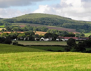
Dunster is a village and civil parish in Somerset, England, within the north-eastern boundary of Exmoor National Park. It lies on the Bristol Channel 2.5 miles (4 km) southeast of Minehead and 20 miles (32 km) northwest of Taunton. At the 2011 Census, it had a population of 817.

Dunkery Beacon at the summit of Dunkery Hill is the highest point on Exmoor and in Somerset, England. It is also the highest point in southern England outside of Dartmoor.
Dowsborough Camp is an Iron Age hill fort on the Quantock Hills near Nether Stowey in Somerset, England. It has been designated as a Scheduled Monument. The fort and associated round barrow has been added to the Heritage at Risk Register due to vulnerability to vehicle damage and erosion.

Bats Castle is an Iron Age hillfort at the top of a 213 metres (699 ft) high hill in the parish of Carhampton south south west of Dunster in Somerset, England.

Black Ball Camp is an Iron Age hillfort South West of Dunster, Somerset, England on the northern summit of Gallox Hill. It is a Scheduled Monument.
Bury Castle is an Iron Age hillfort near Selworthy, Somerset, England. It has been designated as a scheduled monument.

Cow Castle is an Iron Age hillfort 5.75 kilometres (4 mi) West South West of Exford, Somerset, England within the Exmoor National Park. It is a Scheduled Monument. It has been added to the heritage at Risk register because of the risk from bracken.

Sweetworthy is the site of two Iron Age hill forts or enclosures at Luccombe, 4 kilometres (2 mi) south of Porlock, Somerset, England. They are on the north-facing slope of Dunkery Hill. One has a single rampart and external ditch, enclosing 0.25 hectares. The rampart is still visible and the ditch on the east side is used as a trackway. There was a defended settlement above the main site.

The Gallox Bridge in Dunster, Somerset, England dates from the 15th century. It has been designated as a Grade I listed building and scheduled monument. The bridge is in the guardianship of English Heritage.
The River Avill is a small river on Exmoor in Somerset, England.

Mounsey Castle is an Iron Age irregular triangular earthwork of 1.75 hectares north west of Dulverton, Somerset, England. It has been scheduled as an ancient monument. It has been added to the Heritage at Risk Register.
Oldberry Castle is an Iron Age hill fort north west of Dulverton, Somerset, England. It lies approximately 0.5 miles (0.80 km) north-west from Dulverton, close to the Devon border. It has been designated as a Scheduled Ancient Monument.
Berry Castle is an early Roman hillslope enclosure in the West Somerset district of Somerset, England. The hill fort is situated approximately 3.2 miles (5.1 km) west from the village of Luccombe. A series of earthworks survive in Berry Castle; it dates from the late Iron Age or early Romano British period. It has been protected as a scheduled monument.

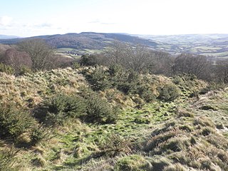
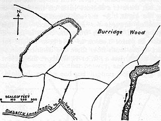
Long Wood Enclosure is an enclosure which may have been a univallate Iron Age hill fort, in the West Somerset district of Somerset, England. The hill fort is situated approximately 3.5 kilometres (2.2 mi) southwest of the village of Dunster. It has been scheduled as an ancient monument.

The Butter Cross in Dunster within the English county of Somerset is a Grade II* listed building and scheduled monument. The cross was originally erected in the late 14th or early 15th century in the main street, and was moved to its current site in the late 18th or early 19th century. Although the head of the cross is missing, the shaft and socket stone are original. The cross is in the care of English Heritage and is managed by the National Trust.

There are over 670 scheduled monuments in the ceremonial county of Somerset in South West England. The county consists of a non-metropolitan county, administered by Somerset Council. The two administratively independent unitary authorities, which were established on 1 April 1996 following the breakup of the county of Avon, are North Somerset and Bath and North East Somerset. These unitary authorities include areas that were once part of Somerset before the creation of Avon in 1974.
West Somerset was a local government district in the English county of Somerset. It merged with Taunton Deane to form Somerset West and Taunton on 1 April 2019.
West Somerset was a local government district located in the English county of Somerset. It merged with Taunton Deane to form Somerset West and Taunton on 1 April 2019.
