Related Research Articles

Belize is a country on the north-eastern coast of Central America. It is bordered by Mexico to the north, the Caribbean Sea to the east, and Guatemala to the west and south. It also shares a water boundary with Honduras to the southeast. It has an area of 22,970 square kilometres (8,867 sq mi) and a population of 441,471 (2022). Its mainland is about 290 km (180 mi) long and 110 km (68 mi) wide. It is the least populated and least densely populated country in Central America. Its population growth rate of 1.87% per year is the second-highest in the region and one of the highest in the Western Hemisphere. Its capital is Belmopan, and its largest city is the namesake city of Belize City. Belize is often thought of as a Caribbean country in Central America because it has a history similar to that of English-speaking Caribbean nations. Belize's institutions and official language reflect its history as a British colony.

Belmopan is the capital city of Belize. Its population in 2010 was 16,451. In addition to being the smallest capital city in the continental Americas by population, Belmopan is the third-largest settlement in Belize, behind Belize City and San Ignacio. Founded as a planned community in 1970, Belmopan is one of the newest national capital cities in the world. Since 2000, Belmopan has been one of two settlements in Belize to hold official city status, along with Belize City.

This article is a demography of the population of Belize including population density, ethnicity, education level, health of the populace, economic status, religious affiliations and other aspects of the population.

Window Rock is a census-designated place that serves as the seat of government and capital of the Navajo Nation, the largest territory in North America of a sovereign Native American nation. The capital lies within the boundaries of the St. Michaels Chapter, adjacent to the Arizona and New Mexico state line. Window Rock is the site of the Navajo Nation governmental campus, which contains the Navajo Nation Council, Navajo Nation Supreme Court, the offices of the Navajo Nation President and Vice President, and many Navajo government buildings.

Chatham is a village in Sangamon County, Illinois, United States. It is located 2.8 miles south of Springfield and has a retail trade area that extends into four other municipalities, including Springfield. The population was 11,500 as of the 2010 census and estimated to be 13,008 as of 2019. The village lies along the original alignment of historic U.S. Route 66.

Rock Falls is a city in Whiteside County, Illinois, United States. The recorded population was 8,606 at the 2020 census, down 7.12% from 9,266 in 2010. The city is located on the Rock River, directly opposite its twin city of Sterling.

Glen Rock is a borough in York County, Pennsylvania, United States. The population was 2,120 at the 2020 census.

Dangriga, formerly known as Stann Creek Town, is a town in southern Belize, located on the Caribbean coast at the mouth of the North Stann Creek River. It is the capital of Belize's Stann Creek District. Dangriga is served by the Dangriga Airport. Commonly known as the "culture capital of Belize" due to its influence on punta music and other forms of Garifuna culture, Dangriga is the largest settlement in southern Belize.

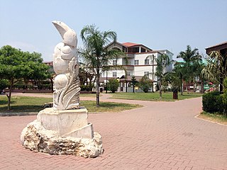
Orange Walk Town is the fourth largest town in Belize, with a population of about 13,400. It is the capital of the Orange Walk District. Orange Walk Town is located on the left bank of the New River, 53 miles (85 km) north of Belize City and 30 miles (48 km) south of Corozal Town. Despite the English name of the city, its residents are primarily Spanish-speaking mestizos. The city is in a very low-lying area of Belize, though the police station sits atop a buried Mayan pyramid at 49 m (161 ft) tall.
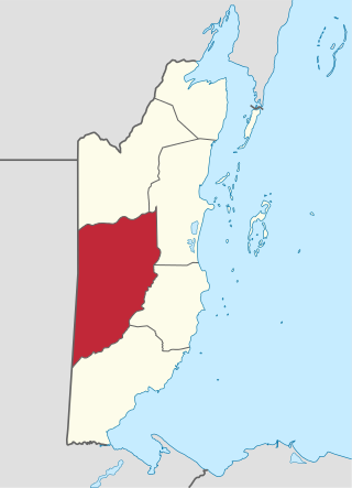
Belize District is a district of the nation of Belize. Its capital is Belize City.
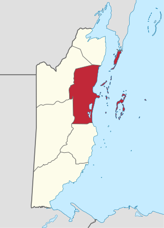
Cayo District is a district located in the west part of Belize. It is the most extensive, second-most populous and third-most densely populated of the six districts of Belize. The district's capital is the town of San Ignacio.
San Ignacio and Santa Elena are towns in western Belize. San Ignacio serves as the cultural-economic hub of Cayo District. It got its start from mahogany and chicle production during British colonisation. Over time it attracted people from the surrounding areas, which led to the diverse population of the town today. San Ignacio is the largest settlement in Cayo District and the second largest in the country, after Belize City.

Hattieville is a village in the Belize District of the nation of Belize. It is located at 17N 88W, at an elevation of 196 feet above mean sea level, and has a population of about 1,300 people. Hattieville was established as a refugee camp after Hurricane Hattie made many people homeless in Belize City when it hit in 1961, but it became a permanent town.

Caye Caulker is a small limestone coral island off the coast of Belize in the Caribbean Sea measuring about 5 miles (8.0 km) by less than 1 mile (1.6 km). The town on the island is known by the name Caye Caulker Village. The population of Caye Caulker is approximately 2,000 people today and still growing.
Christianity is the dominant religion in Belize. The single largest denomination is the Roman Catholic Church with about 40.1% of the population, a reduction from 49.6% of the population in 2000, 57.7% in 1991 and 61.9% in 1980, although absolute numbers have still risen. Other major groups include Pentecostal with 8.4% of the population up from 7.4% in 2000 and 6.3% in 1991, Seventh-day Adventists with 5.4% of the population up from 5.2% in 2000 and 4.1% in 1991. The following of the Anglican Church has been steadily declining, with only 4.7% of the population in 2010 compared to 6.95% in 1991. About 12,000 Mennonites live mostly in the rural districts of Cayo and Orange Walk. People who declared they belong to no religion make up 15.5% of the population in 2010, more than double their 2000 census numbers. 11.2% adhere to other religions which include the Maya religion, Afro-American religions, Mormons, Hindus, Buddhists, Muslims, Baháʼís, Rastafarians and others.

Lenox Hill is a neighborhood on Manhattan's Upper East Side. It forms the lower section of the Upper East Side—east of Park Avenue in the 60s and 70s.
Crooked Tree is a settlement located in the nation of Belize. It is a mainland village located in the Belize District.
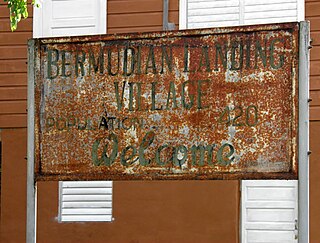
Bermudian Landing is a village in the nation of Belize, located near Scotland Halfmoon in Belize District. The name comes from the Bermuda grass planted by the early loggers to feed their oxen, who were used to drag the mahogany to the landing.
Saint Paul's Bank is a populated settlement located in the nation of Belize. It is a mainland village that is located in Belize District and one of seven villages across 18 - square miles of the Belize River Valley that make up the Community Baboon Sanctuary: Big Falls, St. Paul's Bank, Willow's Bank, Double Head Cabbage, Bermudian Landing, Isabella Bank and Flower's Bank. This village lies along a road which ends at the Belize River, and is well known for the “big falls” on the river. In the dry season these “falls” are large rock outcroppings, creating the largest rapids on the Belize River. These rapids are part of the route of La Ruta Maya, a 4-day canoe race on the Belize River.
Isabella Bank is a village in Belize District in Belize, Central America. It is located on the banks of the Belize River approximately two miles from the village of Bermudian Landing. It can be reached by traveling the Philip Goldson Highway out of Belize City to the junction of the road that branches into Burrell Boom. There is a paved road from Burrell Boom to Isabella Bank. Isabella Bank is well known for having a very respected private primary school- Isabella Harmony Private School. This prestigious village has a small but well respected population of 130 individuals. The central and outlying a bunnger age are located in pine ridge type terrain with very light, sandy, soil. Closer to the river the soil becomes a heavier clay, which supports thicker vegetation. Traditionally a farming community using slash and burn methods, there has been largely a transition to a workforce that commutes to larger metropolitan areas as day laborers. This has been particularly evident in the younger portion of the populace. As of 2016, the village was connected to the pipe water system operated by Belize Water Services. (BWS) Residents also benefit from grid electric service provided by Belize Electricity Limited (BEL). A number of residents have cleared acreage where they raise livestock including cattle and sheep. There is currently no store or shop operating in the village, but supplies are readily available at shops in nearby Bermudian Landing and Scotland Halfmoon. Public transportation includes a number of local bus lines serving surrounding villages and connecting with Belize City.
References
- ↑ Population & Housing Census 2010
| | This article about the geography of Belize is a stub. You can help Wikipedia by expanding it. |