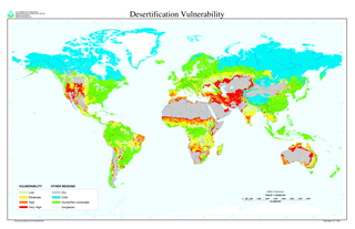
Desertification is a type of land degradation in drylands in which biological productivity is lost due to natural processes or induced by human activities whereby fertile areas become arid. It is the spread of arid areas caused by a variety of factors, such as climate change and overexploitation of soil as a result of human activity.

The Thar Desert, also known as the Great Indian Desert, is an arid region in the north-western part of the Indian subcontinent that covers an area of 205,000 km2 (79,000 sq mi) in India and Pakistan. It is the world's 20th-largest desert, and the world's 9th-largest hot subtropical desert.

Land degradation is a process in which the value of the biophysical environment is affected by a combination of human-induced processes acting upon the land. It is viewed as any change or disturbance to the land perceived to be deleterious or undesirable. Natural hazards are excluded as a cause; however human activities can indirectly affect phenomena such as floods and bush fires.
Land development is the alteration of landscape in any number of ways such as:

Afforestation is the establishment of a forest or stand of trees (forestation) in an area where there was no previous tree cover. Many government and non-governmental organizations directly engage in afforestation programs to create forests and increase carbon capture. Afforestation is an increasingly sought-after method to fight climate concerns, as it is known to increase the soil quality and organic carbon levels into the soil, avoiding desertification. Afforestation is mainly done for conservational and commercial purposes.

Pushkar Lake or Pushkar Sarovar is located in the town of Pushkar near Ajmer city in Ajmer district of the Rajasthan state of western India. Pushkar Lake is a sacred lake of the Hindus. The Hindu scriptures describe it as "Tirtha-Guru" [Thirtha Raj]– the perceptor of pilgrimage sites related to a water-body and relate it to the mythology of the creator-god Brahma, whose most prominent temple stands in Pushkar. The Pushkar Lake finds mention on coins as early as the 4th century BC.

Nagaur District is one of the 50 districts of the state of Rajasthan in western India. Panchayati Raj was introduced here. It is the fifth largest district in Rajasthan and the area of the district is 17,718 km2 (6,841 sq mi). The city of Nagaur is the district headquarters.

Jodhpur District is a district in the State of Rajasthan in western India. The city of Jodhpur is the administrative headquarters of the district.

The Indira Gandhi Canal is the longest canal in India. It starts at the Harike Barrage near Harike, a few kilometers downriver from the confluence of the Satluj and Beas rivers in Punjab state, and ends in irrigation facilities in the Thar Desert in the northwest of Rajasthan state. Previously known as the Rajasthan Canal, it was renamed the Indira Gandhi Canal on 2 November 1984 following the assassination of Prime Minister Indira Gandhi.

The Central Arid Zone Research Institute (CAZRI) is one of the biggest research institutes of the Indian Council of Agricultural Research (ICAR), an autonomous organization working under the aegis of the Department of Agriculture Research and Education (DARE) of the Ministry of Agriculture and Farmers Welfare of Government of India. CAZRI has the distinction of being one of the first institutes in the world exclusively devoted to arid zone research and development. The institute made a humble beginning in 1952 when Government of India initiated Desert Afforestation Research Station at Jodhpur to carry out research on sand dune stabilization and for establishment of shelter belt plantations to arrest wind erosion. It was reorganized as Desert Afforestation and Soil Conservation Station in 1957 and finally in its present form Central Arid Zone Research Institute in 1959 on recommendation of the UNESCO (United Nations Educational, Scientific and Cultural Organization) expert, Prof. C.S. Christian of the Commonwealth Scientific and Industrial Research Organisation (CSIRO), Australia. In 1966, the institute was brought under the administrative control of Indian Council of Agricultural Research (ICAR), New Delhi.

Isha Foundation is a nonprofit, spiritual organisation that was founded in 1992 near Coimbatore, Tamil Nadu, India, by Sadhguru. It hosts the Isha Yoga Centre, which offers yoga programs under the name Isha Yoga. The foundation is run "almost entirely" by volunteers. The word isha means "the formless divine".

Jal Mahal is a palace in the middle of the Man Sagar Lake in Jaipur city, the capital of the state of Rajasthan, India. The palace was originally constructed in 1699; the building and the lake around it were later renovated and enlarged in the 18th century by Maharaja Jai Singh II of Amber.

The Great Green Wall or Great Green Wall of the Sahara and the Sahel is a project adopted by the African Union in 2007, initially conceived as a way to combat desertification in the Sahel region and hold back expansion of the Sahara, by planting a wall of trees stretching across the entire Sahel from Djibouti, Djibouti to Dakar, Senegal. The original dimensions of the "wall" were slated to be 15 Km wide and 7,775 Km long, but the program has expanded to encompass nations in both northern and western Africa. The modern green wall has since evolved into a program promoting water harvesting techniques, greenery protection and improving indigenous land use techniques, aimed at creating a mosaic of green and productive landscapes across North Africa. The ongoing goal of the project is to restore 100 million hectares of degraded land and capture 250 million tonnes of carbon dioxide, and create 10 million jobs in the process all by 2030.

Khajuwala is a town in the Bikaner district of Rajasthan, India. It is located near the Indo-Pakistan border and is situated around 113 kilometres (70 mi) from the district headquarters Bikaner. It is an Municipality with several villages under its administration. It produces a lot of raw cotton and wheat. Indira Gandhi Canal has brought about development of this area. It is a big agro products market in Bikaner district. Earlier its name was Beriyawali. It is also seat in Rajasthan legislative assembly. The current elected Member of Legislative assembly (MLA) from Khajuwala is Govind ram meghwal (INC). Khajuwala has recently been given a status of Municipality.
The Great Green Wall, officially known as the Three-North Shelter Forest Program, also known as the Three-North Shelterbelt Program, is a series of human-planted windbreaking forest strips (shelterbelts) in China, designed to hold back the expansion of the Gobi Desert, and provide timber to the local population. The program started in 1978, and is planned to be completed around 2050, at which point it will be 4,500 kilometres (2,800 mi) long.
The Kumtag Desert, is an arid landform in Northwestern China, which was proclaimed as a national park in the year 2002.

Desert greening is the process of man-made reclamation of deserts for ecological reasons (biodiversity), farming and forestry, but also for reclamation of natural water systems and other ecological systems that support life. The term "desert greening" is intended to apply to both cold and hot arid and semi-arid deserts. It does not apply to ice capped or permafrost regions. Desert greening has the potential to help solve global water, energy, and food crises. It pertains to roughly 32 million square kilometres of land.

The Mu Us Desert is a desert in northern China. Its south-eastern end is crossed by the Great Wall of China. The Mu Us forms the southern portion of the Ordos Desert and part of the Ordos Loop. The Wuding River drains the area, and then flows into the Yellow River.

The Economics of Land Degradation (ELD) Initiative is a global initiative which aims to increase awareness of the benefits of sustainable land management and economic consequences of land degradation.

Environmental issues in Yemen are abundant and are divided into the categories of land and water. In the aspect of water, Yemen has limited natural fresh water resources and inadequate supplies of potable water. As for the land, two main issues of Yemen are overgrazing and desertification. Yemen has signed several international agreements: Climate Change-Kyoto Protocol, Desertification, Endangered Species, Environmental Modification, Hazardous Wastes, Law of the Sea, and Ozone Layer Protection.
