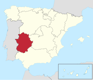
Extremadura is a landlocked autonomous community of Spain. Its capital city is Mérida, and its largest city is Badajoz. Located in the central-western part of the Iberian Peninsula, it is crossed from east to west by the Tagus and Guadiana rivers. The autonomous community is formed by the two largest provinces of Spain: Cáceres and Badajoz. Extremadura is bordered by Portugal to the west and by the autonomous communities of Castile and León (north), Castilla–La Mancha (east), and Andalusia (south).

In Spain, a comarca is either a traditional territorial division without any formal basis, or a group of municipalities, legally defined by an autonomous community for the purpose of providing common local government services. In English, a comarca is equivalent to a district, county, area or zone.

Moros y Cristianos or Moros i Cristians, literally in English Moors and Christians, is a set of festival activities which are celebrated in many towns and cities of Spain, mainly in the southern Valencian Community. According to popular tradition the festivals commemorate the battles, combats and fights between Moors and Christians during the period known as Reconquista. There are also festivals of Moros y Cristianos in Spanish America.

Mohedas de Granadilla is a municipality located in the province of Cáceres, Extremadura, Spain. According to the 2005 census (INE), the municipality has a population of 1061 inhabitants.

Palomero is a municipality located in the province of Cáceres, Extremadura, Spain. According to the 2007 census (INE), the municipality has a population of 498 inhabitants.
La Pesga is a municipality located in Trasierra/Tierras de Granadilla, province of Cáceres, Extremadura, Spain. According to the 2023 census, the municipality has a population of 977, down from 1162 inhabitants as of the 2005 census (INE).

Zarza de Granadilla is a Spanish municipality in Cáceres Province, Extremadura. Zarza de Granadilla has a population of 1873.
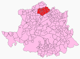
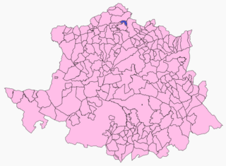
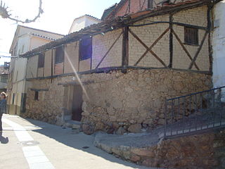
Trasierra/Tierras de Granadilla, traditionally known as Tierras de Granadilla, is a comarca at the northern end of province of Cáceres in Extremadura, one of Spain's seventeen Autonomous Communities.
Gata is a municipality located in the province of Cáceres, Extremadura, Spain. The Postal Code is 10860.

Aceituna is a municipality in the province of Cáceres and autonomous community of Extremadura, Spain. The municipality covers an area of 620 square kilometres (240 sq mi) and as of 2011 had a population of 620 people.
Ahigal is a municipality in the province of Cáceres and autonomous community of Extremadura, Spain. The municipality covers an area of 52.07 square kilometres (20.10 sq mi) and as of 2011 had a population of 1435 people.

Collado de la Vera is a municipality in the province of Cáceres and autonomous community of Extremadura, Spain. The municipality covers an area of 44.94 square kilometres (17.35 sq mi) and as of 2011 had a population of 188 people.Now it has a population of about 190 people
Cuacos de Yuste is a municipality in the province of Cáceres and autonomous community of Extremadura, Spain. The municipality covers an area of 52.6 square kilometres (20.3 sq mi) and as of 2011 had a population of 902 people. It is best known for the Monastery of Yuste, where Charles V, Holy Roman Emperor, retired and died.

Descargamaría is a municipality in the province of Cáceres and autonomous community of Extremadura, Spain. The municipality covers an area of 49.92 square kilometres (19.27 sq mi) and as of 2011 had a population of 190 people.
La Granja or Granja de Granadilla is a municipality in the province of Cáceres and autonomous community of Extremadura, Spain. The municipality covers an area of 14.94 square kilometres (5.77 sq mi. In 2011 it had a population of 364 people. It is located between the shires of Tierras de Granadilla and Ambroz Valley.

Guijo de Coria is a municipality in the province of Cáceres and autonomous community of Extremadura, Spain. The municipality covers an area of 74.75 square kilometres (28.86 sq mi) and as of 2011 had a population of 263 people.
Rebollar is a municipality in the province of Cáceres and autonomous community of Extremadura, Spain. The municipality covers an area of 12 square kilometres (4.6 sq mi) and as of 2011 had a population of 230 people.

Villar de Plasencia is a municipality located in the province of Cáceres, in the autonomous community of Extremadura, Spain. The municipality covers an area of 24.99 square kilometres (9.65 sq mi) and as of 2011 has a population of 243 people.

Alagón del Río is a municipality located in the province of Cáceres, Extremadura, Spain. According to the 2013 census (INE), the municipality has a population of 889 inhabitants. Alagón del Río became independent from Galisteo in November 2009.

The Cave of Maltravieso in Cáceres, Extremadura, Spain, was discovered in 1951. It shows traces of human occupation from the Middle Paleolithic. It contains cave art, most notably a total of 71 hand stencils, enumerated in the 1990s using ultraviolet photography, but also linear designs and some animal paintings. In a 2018 study based on uranium-thorium dating, a hand stencil from the Cave of Maltravieso was dated to 64,000 years ago. This would make it Middle Paleolithic art, predating the presence of European early modern humans, with important implications for Neanderthal behavior.
