
Transport infrastructure within Chad is generally poor, especially in the north and east of the country. River transport is limited to the south-west corner. As of 2011 Chad had no railways though two lines are planned - from the capital to the Sudanese and Cameroonian borders during the wet season, especially in the southern half of the country. In the north, roads are merely tracks across the desert and land mines continue to present a danger. Draft animals remain important in much of the country.

Ground transport in the Democratic Republic of the Congo (DRC) has always been difficult. The terrain and climate of the Congo Basin present serious barriers to road and rail construction, and the distances are enormous across this vast country. Furthermore, chronic economic mismanagement and internal conflict has led to serious under-investment over many years.

Transport in Ethiopia is overseen by the Ministry of Transport and Communications. Over the last years, the Ethiopian federal authorities have significantly increased funding for rail and road construction to build an infrastructure, that allows better economic development.
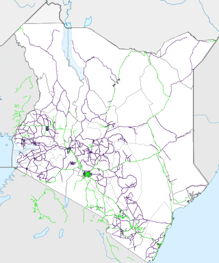
Transport in Kenya refers to the transportation structure in Kenya. The country has an extensive network of paved and unpaved roads.
Transport in Tanzania includes road, rail, air and maritime networks. The road network is 86,472 kilometres (53,731 mi) long, of which 12,786 kilometres (7,945 mi) is classified as trunk road and 21,105 kilometres (13,114 mi) as regional road. The rail network consists of 3,682 kilometres (2,288 mi) of track. Commuter rail service is in Dar es Salaam only. There are 28 airports, with Julius Nyerere International being the largest and the busiest. Ferries connect Mainland Tanzania with the islands of Zanzibar. Several other ferries are active on the countries' rivers and lakes.

The East African Community (EAC) is an intergovernmental organisation in East Africa. The EAC's membership consists of eight states: Democratic Republic of the Congo, the Federal Republic of Somalia, the Republics of Burundi, Kenya, Rwanda, South Sudan, Uganda, and Tanzania. William Ruto, the president of Kenya, is the current EAC chairman. The organisation was founded in 1967, collapsed in 1977, and was revived on 7 July 2000. The main objective of the EAC is to foster regional economic integration.
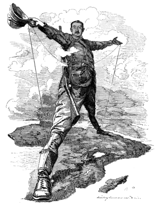
The Cape to Cairo Railway is an unfinished project to create a railway line crossing from southern to northern Africa. It would have been the largest, and most important, railway of the continent. It was planned as a link between Cape Town in South Africa and Port Said in Egypt.

Saskatchewan, the middle of Canada's three prairie provinces, has an area of 588,276.09 square kilometres (227,134.67 sq mi) and population of 1,150,632, mostly living in the southern half of the province.

As the third largest and second most populous country in Latin America, Mexico has developed an extensive transportation network to meet the needs of its economy and growing population. Regulated by the Secretariat of Communications and Transportation, a federal executive cabinet branch, Mexico's transportation system includes modern highways, a well-connected bus network, railways primarily used for freight, and a network of domestic and international airports.
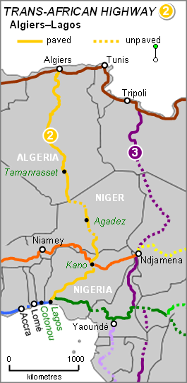
The Trans-Sahara Highway or TAH 2, formally the Trans-Saharan Road Corridor (TSR), and also known as the African Unity Road, is a transnational infrastructure project to facilitate trade, transportation, and regional integration among six African countries: Algeria, Chad, Mali, Niger, Nigeria, and Tunisia. It runs roughly 4,500 km north to south across the Sahara desert from Algiers, Algeria on the Mediterranean coast of North Africa to Lagos, Nigeria on the Atlantic coast of West Africa; subsequently, it is sometimes known as the Algiers–Lagos Highway or Lagos–Algiers Highway.
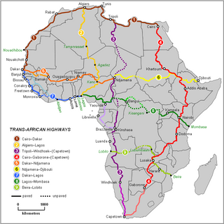
The Trans-African Highway network comprises transcontinental road projects in Africa being developed by the United Nations Economic Commission for Africa (UNECA), the African Development Bank (ADB), and the African Union in conjunction with regional international communities. They aim to promote trade and alleviate poverty in Africa through highway infrastructure development and the management of road-based trade corridors. The total length of the nine highways in the network is 56,683 km (35,221 mi).

Kenya Vision 2030 is a Kenyan development program, aiming to raise the average standard of living in Kenya to middle income by 2030. It was launched on 10 June 2008 by President Mwai Kibaki. Developed through "an all-inclusive and participatory stakeholder consultative process, involving Kenyans from all parts of the country," the Vision is based on three "pillars": Economic, Social, and Political. The Vision's adoption comes after the country's GDP growth went from 0.6% in 2002 to 6.1% in 2006, under Kibaki's Economic Recovery Strategy for Wealth and Employment Creation (ERS).

The African Free Trade Zone (AFTZ) is a free trade zone announced at the EAC-SADC-COMESA Summit on 22 October 2008 by the heads of Southern African Development Community (SADC), the Common Market for Eastern and Southern Africa (COMESA) and the East African Community (EAC). The African Free Trade Zone is also referred to as the African Free Trade Area in some official documents and press releases.

The Cairo–Cape Town Highway is Trans-African Highway 4 in the transcontinental road network being developed by the United Nations Economic Commission for Africa (UNECA), the African Development Bank (AfDB), and the African Union. The route has a length of 10,228 km (6,355 mi) and links Cairo in Egypt to Cape Town in South Africa.

Much of the influence of the Soviet Union can be seen in the infrastructure of Central Asia. Central Asia is a nexus of said infrastructure for transportation, goods delivery and energy distribution. Much of the industrial infrastructure had greatly declined in the 1990s, after the fall of the Soviet Union, especially in Kyrgyzstan and Tajikistan. The roads, railroads and energy lines are thus oriented towards the Russian Federation and away from other regional neighbors, such as China, Afghanistan or Iran.

China–Tanzania relations are the foreign relations between China and Tanzania. China established diplomatic relations with Tanganyika and Zanzibar on December 9, 1961, and December 11, 1963, respectively. When Tanganyika and Zanzibar were united and became Tanzania on April 26, 1964, China extended its diplomatic ties to it.

Middle East economic integration refers to the process of improving economic cooperation, coordination, and connectivity among countries in the Middle East and North Africa (MENA) region. This process aims to create a unified economic space that allows for the free movement of goods, services, capital, and labor across national borders within the region. The objectives behind such integration include enhancing regional trade, stimulating economic growth, achieving economies of scale, and fostering stability and peace through economic interdependence.

The Mtwara Development Project is a major infrastructure development project involving southern Tanzania, northern Mozambique, eastern Malawi and Eastern Zambia. The goal of this project is to provide road, rail and waterway access from the surrounding region to the Port of Mtwara. The region and the corridor has been neglected by the respective governments for over 40 years and the recent discovery of oil, gas and various minerals has kick started the development of the project. A road and rail link is to be built from the port of Mtwara to Mbamba Bay on Lake Nyasa to link Malawi to the corridor and further road links into Mozambique will facilitate access to northern Mozambique.
The R3 highway is a primary road in Zimbabwe that runs from the capital city, Harare, to the Chirundu Border Post with Zambia. It is also known as the A1 highway. It is part of both the Beira–Lobito Highway and the Cape to Cairo Road.

Chirundu–Beitbridge Road Corridor is a Trans-African Highway Network Zimbabwean link between South Africa and Zambia. It is part of the North–South Corridor Project and forms the entire Zimbabwean section of the Cape to Cairo Road.
