Granite, Virginia

Last updated
In 1895, Granite was located on the Southern Railway about 5 miles west of Manchester and 3 miles east of Bon Air in Chesterfield County, Virginia Va 1895 granite.jpg
In 1895, Granite was located on the Southern Railway about 5 miles west of Manchester and 3 miles east of Bon Air in Chesterfield County, Virginia

Granite was an unincorporated community in Chesterfield County, Virginia. It was originally located along the Richmond and Danville Railroad five miles west of Manchester and about a mile south of the rapids of the James River along Powhite Creek. Most of the Granite area of Chesterfield County was annexed by the independent city of Richmond on January 1, 1970.

Contents

A community in the stone industry

According to documents on file at the Library of Virginia, in April 1872, notice was published in Petersburg that Mathew Hall had been appointed postmaster of a new U.S. Post Office at Granite. [1]

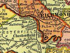
Granite was named for the granite rock formations which underlie the rapids of the river at the geological fall line which begin downstream from the current Williams Island Dam. Mining this granite was the basis for quarries which were located on both sides of the river in the vicinity. Granite stone quarried nearby was used to construct the State, War and Navy building in Washington, D.C., and to build the 3-foot granite walls of Richmond's Gothic City Hall at 10th and Capitol Streets which was completed in 1894. (It became known as "Old City Hall" when replaced in 1972 with a new structure). [2] [3] However, some quarrying operations had already been active in the area since the early 18th century.

Descendants of slaves lived in Granite where they were a substantial labor source for the nearby quarries. Black churches were established, but only a few remnants are indications of the existence of the town and former residents. In the 20th century, they had mostly been displaced by gentrification from the expanding City of Richmond with new roads and residential suburbs such as Stratford Hills and Southampton. [4]

Quarries and companies which operated near Granite were listed in Mineral Resources of Virginia by Thomas Leonard Watson, Ray Smith Bassler, Heinrich Ries, and Roy Jay, published in 1907 as:

At that time (1907), Granite Station was located on the Southern Railway (successor to the Richmond and Danville Railroad) and the McIntosh Quarry had a spur track. The McIntosh Quarry furnished the stone used in the approaches and steps in the renovation and expansion of the Virginia State Capitol which had recently been completed (1904–06). [5]

Suburban growth reaches Granite

Manchester merged with Richmond in 1910 and the combined city grew rapidly. Soon Granite was not a remote place. As the land around the Granite area was developed with new streets and housing after World War II, Granite lost its separate identity as suburban growth overtook it. A portion of modern-day Forest Hill Avenue was earlier named Granite Road, and extended from Westover Hills into Chesterfield County, ending at Bon Air.

Most of the Granite area of Chesterfield County was annexed by the independent city of Richmond on January 1, 1970. The neighborhoods in the city in the area of Granite include Granite Acres and Willow Oaks. Nearby, Netherwood Drive was named for the former quarry at its western end. Since 1959, Granite Recreation Corporation has occupied the former site of the Granite Development Company Quarry. The entrance driveway off Glyndon Lane has a private grade crossing of the railroad. [6]

See also

Related Research Articles

Richmond, Virginia Capital of Virginia

Richmond is the capital city of the Commonwealth of Virginia in the United States. It is the center of the Richmond Metropolitan Statistical Area (MSA) and the Greater Richmond Region. Richmond was incorporated in 1742 and has been an independent city since 1871. As of the 2010 census, the city's population was 204,214; in 2020, the population had grown to 226,610, making Richmond the fourth-most populous city in Virginia. The Richmond Metropolitan Area has a population of 1,260,029, the third-most populous metro in the state.

Petersburg, Virginia Independent city in Commonwealth of Virginia, United States

Petersburg is an independent city in the Commonwealth of Virginia in the United States. As of the 2010 census, the population was 32,420. The Bureau of Economic Analysis combines Petersburg with Dinwiddie County for statistical purposes. The city is 21 miles (34 km) south of the commonwealth (state) capital city of Richmond.

Chesterfield County, Virginia County in Virginia

Chesterfield County is located just south of Richmond in the Commonwealth of Virginia. The county's borders are primarily defined by the James River to the north and the Appomattox River to the south. Its county seat is Chesterfield Court House.

Bon Air, Virginia Census-designated place in Virginia, United States

Bon Air is a census-designated place (CDP) in Chesterfield County, Virginia, United States. The population was 16,366 at the 2010 census. The community is considered a suburb of the independent city of Richmond in the Richmond-Petersburg region and is a part of the Southside neighborhoods. Originally developed as a resort, a central portion of Bon Air has been designated as a National Historic District with many structures of Victorian design from the late 19th and early 20th centuries. Its name means "good air," reflecting its role as a resort getaway that wealthy Richmonders enjoyed for its fresh air as opposed to the dirty air of Richmond's industrial downtown of the late 19th century.

Manchester, Richmond, Virginia Former Independent City in Virginia, United States of America

Manchester is a former independent city in Virginia in the United States. Prior to receiving independent status, it served as the county seat of Chesterfield County, between 1870 and 1876. Today, it is a part of the city of Richmond, Virginia.

Chesterfield Railroad

The Chesterfield Railroad was located in Chesterfield County, Virginia. It was a 13-mile (21-kilometer) long mule-and-gravity powered line that connected the Midlothian coal mines with wharves that were located at the head of navigation on the James River just below the Fall Line at Manchester. It began operating in 1831 as Virginia's first common carrier railroad.

Richmond and Danville Railroad

The Richmond and Danville Railroad (R&D) Company was a railroad that operated independently from 1847 until 1894, first in the U.S. state of Virginia and later on 3,300 miles (5,300 km) of track in nine states.

Midlothian, Virginia Unincorporated area in Virginia, United States

Midlothian is an unincorporated area in Chesterfield County, Virginia, U.S. Settled as a coal town, Midlothian village experienced suburbanization effects and is now part of the western suburbs of Richmond, Virginia south of the James River in the Greater Richmond Region. Because of its unincorporated status, Midlothian has no formal government, and the name is used to represent either the original small Village of Midlothian, located on Midlothian Turnpike (US-60) between Old Buckingham Road and Salisbury Drive, or a vast expanse of Chesterfield County in the northwest portion of Southside Richmond covered by three zip codes served by the Midlothian post office. These zip codes are not coterminous with the Midlothian Magisterial District associated with the Chesterfield County government.

This article is about the many neighborhoods and districts in the Greater Richmond, Virginia area. Note that this article is an attempt to be inclusive of the broader definitions of the areas which are often considered part of the Greater Richmond Region, based on their urban or suburban character and nature, rather than by strictly political boundaries.

Science Museum of Virginia Science museum in Richmond, Virginia

The Science Museum of Virginia is a science museum located in Richmond, Virginia. Established in 1970, it is an agency of the Commonwealth of Virginia. It is housed in the former Broad Street Station, built in 1917.

Falling Creek (James River tributary)

Falling Creek is a tributary of the James River located near Richmond, Virginia. Approximately 23 miles (37 km) in length, it varies in width between 10 feet (3.0 m) at its source to several hundred feet in the Falling Creek Reservoir. Falling Creek rises in the Salisbury section of northwestern Chesterfield County, flows through Southside Richmond and empties into the James River roughly one mile south of the Richmond city limits. A dam located in the Meadowbrook section of the county at Hopkins Road forms the Falling Creek Reservoir, formerly used as northern Chesterfield's drinking water supply.

Southside (Richmond, Virginia)

The Southside of Richmond is an area of the Metropolitan Statistical Area surrounding Richmond, Virginia. It generally includes all portions of the City of Richmond which lie south of the James River, and includes all of the former city of Manchester. Depending on context, the term "Southside of Richmond" can include some northern areas of adjacent Chesterfield County, Virginia in the Richmond-Petersburg region. With minor exceptions near Bon Air, VA, the Chippenham Parkway forms the border between Chesterfield County and the City of Richmond portions of Southside, with some news agencies using the term "South Richmond" to refer to the locations in Southside located in the city proper.

Transportation in Richmond, Virginia

Transportation in Richmond, Virginia and its immediate surroundings include land, sea and air modes. This article includes the independent city and portions of the contiguous counties of Henrico and Chesterfield. While almost all of Henrico County would be considered part of the Richmond area, southern and eastern portions of Chesterfield adjoin the three smaller independent cities of Petersburg, Hopewell, and Colonial Heights, collectively commonly called the Tri-Cities area. A largely rural section of southwestern Chesterfield may be considered not a portion of either suburban area.

Westham Bridge

Westham Bridge crossed the James River between Henrico County and Chesterfield County. The bridge was located between Bosher Dam and Williams Island Dam just west of the 7 miles of rapids and falls which constitute the fall line of the James River at Richmond, Virginia.

Tri-Cities, Virginia

The Tri-Cities of Virginia is an area in the Greater Richmond Region which includes the three independent cities of Petersburg, Colonial Heights, and Hopewell and portions of the adjoining counties of Chesterfield, Dinwiddie, and Prince George in south-central Virginia. Other unincorporated communities located in the Tri-Cities area include Ettrick, Fort Lee, and City Point, the latter formerly a historic incorporated town which was annexed to become part of the City of Hopewell.

Richmond in the American Civil War

Richmond, Virginia served as the capital of the Confederate States of America for almost the whole of the American Civil War. It was a vital source of weapons and supplies for the war effort, and the terminus of five railroads.

Warwick Road in Chesterfield County, Virginia, was one of the older roadways in the area extending across the northern section of the county. Established in the 18th century in the Virginia Colony, the Warwick Road effectively provided a portage around the portion of the James River containing dams and rapids near the fall line in the area of the towns of Manchester and Richmond, Virginia, which were located along the south and north banks of the river respectively.

Forest Hill Park (Richmond, Virginia)

Forest Hill Park, known for its "Stone house" called Boscobel, is a popular and historic 105-acre (0.4 km2) urban park in Richmond, Virginia. Starting as a private property, the park has had several owners and uses before its present one, the City of Richmond.

George Craghead Gregory was an American attorney, businessman, historian, and author. He lived with his wife and seven children at "Granite Hall", an estate located near Granite in northwestern Chesterfield County about 8 miles (13 km) west of Richmond, Virginia.

Aquia is a district of Stafford County, in the U.S. state of Virginia. It is named for Aquia Creek, which leads to the Potomac River. Nearby historic locations include Aquia Church and the remains of Aquia quarry. Cliffs of the local Aquia Creek sandstone had been visible from the Potomac River near its confluence with Aquia Creek during colonial times. It was quarried to construct many buildings nearby, as well as in Washington, D.C., including the White House, National Capitol Columns and Washington Monument. It was a stop on the Richmond, Fredericksburg and Potomac Railroad which was replaced by, CSXT.

References

  1. http://www.lva.lib.va.us/
  2. Building Stones of the United States and Statistics of the Quarry Industry For 1880. Washington, D. C.: Government Printing Office. 1884. p. 360. ISBN   9780883544334 . Retrieved 11 February 2020.
  3. "Archived copy". Archived from the original on 2008-07-26. Retrieved 2008-10-09.CS1 maint: archived copy as title (link)
  4. Williams, MICHAEL PAUL. "Stratford Hills used to be called Granite". Richmond Times-Dispatch. Retrieved 2021-09-25.
  5. "Images of the Virginia State Capitol, Richmond, Virginia by Jefferson".
  6. "Granite Recreation".

Coordinates: 37°31′59″N77°30′26″W / 37.53306°N 77.50722°W / 37.53306; -77.50722