
Kennewick is a city in Benton County in the U.S. state of Washington. It is located along the southwest bank of the Columbia River, just southeast of the confluence of the Columbia and Yakima rivers and across from the confluence of the Columbia and Snake rivers. It is the most populous of the three cities collectively referred to as the Tri-Cities. The United States Census Bureau estimated the population to be 85,158 as of 2023, up from 83,921 at the 2020 United States census.
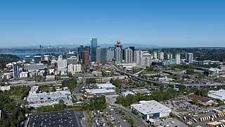
Bellevue is a city in the Eastside region of King County, Washington, United States, located across Lake Washington from Seattle. It is the third-largest city in the Seattle metropolitan area, and the fifth-largest city in Washington. It has variously been characterized as a satellite city, a suburb, a boomburb, or an edge city. The population was 151,854 at the 2020 census. The city's name is derived from the French term belle vue.

Marysville is a city in Snohomish County, Washington, United States, part of the Seattle metropolitan area. The city is located 35 miles (56 km) north of Seattle, adjacent to Everett on the north side of the Snohomish River delta. It is the second-largest city in Snohomish County after Everett, with a population of 70,714 at the time of the 2020 U.S. census. As of 2015, Marysville was also the fastest-growing city in Washington state, growing at an annual rate of 2.5 percent.

Fremont is a neighborhood in the North Central District of Seattle, Washington, United States. Originally a separate city, it was annexed to Seattle in 1891. It is named after Fremont, Nebraska, the hometown of two of its founders: Luther H. Griffith and Edward Blewett.
The Seattle, Lake Shore and Eastern Railway (SLS&E) was a railroad founded in Seattle, Washington, on April 28, 1885, with three tiers of purposes: Build and run the initial line to the town of Ballard, bring immediate results and returns to investors; exploit resources east in the valleys, foothills, Cascade Range, and Eastern Washington in 19th-century style, attracting more venture capital; and boost a link to a transcontinental railroad for Seattle, the ultimate prize for incorporation. The historical accomplishment of the line was Seattle to Sumas at the border, with British Columbia, Canada, connecting with the Canadian Pacific transcontinental at the border at Huntingdon, British Columbia, now part of the City of Abbotsford.

The Seattle Post-Intelligencer is an online newspaper and former print newspaper based in Seattle, Washington, United States.

The Lacey V. Murrow Memorial Bridge is a floating bridge in the Seattle metropolitan area of the U.S. state of Washington. It is one of the Interstate 90 floating bridges that carries the eastbound lanes of Interstate 90 across Lake Washington from Seattle to Mercer Island. Westbound traffic is carried by the adjacent Homer M. Hadley Memorial Bridge.

State Route 99 (SR 99), also known as the Pacific Highway, is a state highway in the Seattle metropolitan area, part of the U.S. state of Washington. It runs 49 miles (79 km) from Fife to Everett, passing through the cities of Federal Way, SeaTac, Seattle, Shoreline, and Lynnwood. The route primarily follows arterial streets, including Aurora Avenue, and has several freeway segments, including the tolled SR 99 Tunnel in Downtown Seattle. SR 99 was officially named the William P. Stewart Memorial Highway by the state legislature in 2016, after a campaign to replace an unofficial moniker honoring Confederate president Jefferson Davis.

The University Bridge is a double-leaf bascule bridge in Seattle, Washington that carries Eastlake Avenue traffic over Portage Bay between Eastlake to the south and the University District to the north. It opened on July 1, 1919, and was extensively rebuilt from 1932 to 1933. It is included in the National Register of Historic Places.

The Aurora Bridge is a cantilever and truss bridge in Seattle, Washington, United States. It carries State Route 99 over the west end of Seattle's Lake Union and connects Queen Anne and Fremont. The bridge is located just east of the Fremont Cut, which itself is spanned by the Fremont Bridge.

Transportation in Seattle is largely focused on the automobile like many other cities in western North America; however, the city is just old enough for its layout to reflect the age when railways and trolleys predominated. These older modes of transportation were made for a relatively well-defined downtown area and strong neighborhoods at the end of several former streetcar lines, now mostly bus lines.

South Park is a neighborhood in Seattle, Washington. It is located just south of Georgetown across the Duwamish River, and just north of the city of Tukwila. Its main thoroughfares are West Marginal Way S., S. Cloverdale Street and 14th Ave. S (north-and-south). South Park connects to Georgetown by two bridges at 1st Ave S. at the northmost end of the neighborhood, and the South Park Bridge at the north end of 14th Ave. South.

Seattle is a city on the West Coast of the United States. It is the seat of King County, Washington. With a 2023 population of 755,078 it is the most populous city in both the state of Washington and the Pacific Northwest region of North America, and the 18th-most populous city in the United States. The Seattle metropolitan area's population is 4.02 million, making it the 15th-largest in the United States. Its growth rate of 21.1% between 2010 and 2020 made it one of the country's fastest-growing large cities.

Interstate 90 (I-90), designated as the American Veterans Memorial Highway, is a transcontinental Interstate Highway that runs from Seattle, Washington, to Boston, Massachusetts. It crosses Washington state from west to east, traveling 298 miles (480 km) from Seattle across the Cascade Mountains and into Eastern Washington, reaching the Idaho state line east of Spokane. I-90 intersects several of the state's other major highways, including I-5 in Seattle, I-82 and U.S. Route 97 (US 97) near Ellensburg, and US 395 and US 2 in Spokane.

Washington, officially the State of Washington, is a state in the Pacific Northwest region of the United States. It is often referred to as Washington state to distinguish it from the national capital, both named after George Washington. Washington borders the Pacific Ocean to the west, Oregon to the south, Idaho to the east, and shares an international border with the Canadian province of British Columbia to the north. Olympia is the state capital, and the most populous city is Seattle.

Colman Dock, also called Pier 52, is the primary ferry terminal in Seattle, Washington, United States. The original pier is no longer in existence, but the terminal, now used by the Washington State Ferries system, is still called "Colman Dock". The terminal serves two routes to Bainbridge Island and Bremerton and has an adjacent passenger-only facility at Pier 50 for King County Water Taxi and Kitsap Fast Ferries routes.
The North Bank Depot Buildings, in central Portland, Oregon, United States, are a pair of buildings formerly used as a freight warehouse and passenger terminal for the Spokane, Portland and Seattle Railway (SP&S). Formed in 1905, the SP&S was commonly known as the North Bank Road during the period in which these buildings were in use. The Portland buildings' passenger facilities were also used by the Oregon Electric Railway after that railway was acquired by the SP&S. Located in what is now known as the Pearl District, the buildings were listed on the National Register of Historic Places in 1996. They were in use by the SP&S and its successor, Burlington Northern Railroad, from 1908 until the 1980s. Only the east building was used as a passenger station, and this usage lasted from 1908 until 1931.

The Microsoft campus is the corporate headquarters of Microsoft Corporation, located in Redmond, Washington, United States, a part of the Seattle metropolitan area. Microsoft initially moved onto the grounds of the campus on February 26, 1986, shortly before going public on March 13. The headquarters has undergone multiple expansions since its establishment and is presently estimated to encompass over 8 million square feet (740,000 m2) of office space and have over 50,000 employees.