Great Bahama Canyon

Last updated
The Bahamas as seen from space. The egress of the Great Bahama Canyon into the Atlantic Ocean is the dark blue channel at upper center. Bahamas 2009.jpg
The Bahamas as seen from space. The egress of the Great Bahama Canyon into the Atlantic Ocean is the dark blue channel at upper center.

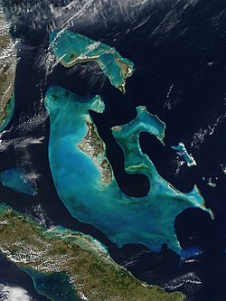
The Great Bahama Canyon is a V-shaped [1] submarine canyon system in the Bahamas that cuts between the Abaco Islands to the north and Eleuthera island to the south. It separates the Bahama Banks and forms one of the deepest underwater canyon systems known. [2] [3] There are three branches: the Tongue of the Ocean running south between Andros and New Providence, and the northeast and northwest Providence Channel. [4] The canyon walls reach heights of 5 kilometres (3 mi) [1] , taller than any canyon walls on land. This canyon system has remained open through a process of submarine erosion. [1]

Related Research Articles

The Bahamas Country in North America

The Bahamas, known officially as the Commonwealth of The Bahamas, is a country within the Lucayan Archipelago of the West Indies in the Atlantic. It takes up 97% of the Lucayan Archipelago's land area and is home to 88% of the archipelago's population. The archipelagic state consists of more than 700 islands, cays, and islets in the Atlantic Ocean, and is located north of Cuba and northwest of the island of Hispaniola and the Turks and Caicos Islands, southeast of the US state of Florida, and east of the Florida Keys. The capital is Nassau on the island of New Providence. The Royal Bahamas Defence Force describes The Bahamas' territory as encompassing 470,000 km2 (180,000 sq mi) of ocean space.

Geography of the Bahamas

The Bahamas are a group of about 700 islands and cays in the western Atlantic Ocean, of which only between 30 and 40 are inhabited. The largest of the islands is Andros Island, located north of Cuba and 200 kilometres southeast of Florida. The Bimini islands are to its northwest. To the North is the island of Grand Bahama, home to the second-largest city in the country, Freeport. The island of Great Abaco is to its east. In the far south is the island of Great Inagua, the second-largest island in the country. Other notable islands include Eleuthera, Cat Island, San Salvador Island, Acklins, Crooked Island, and Mayaguana. Nassau is the capital and largest city, located on New Providence. The islands have a tropical savannah climate, moderated by the Gulf Stream. The total size is 13,878 km2 (5,358 sq mi). Due to the many widespread islands it has the 41st largest Exclusive Economic Zone of 654,715 km2 (252,787 sq mi).

This article talks about transportation in the Bahamas, a North American archipelagic state in the Atlantic Ocean.

Abaco Islands Group of islands in the Bahamas

The Abaco Islands lie in the northern Bahamas, 180 miles off the South Florida coast. They comprise the main islands of Great Abaco and Little Abaco, along with smaller barrier cays. The northernmost are Walker's Cay, and its sister island Grand Cay. To the south, the next inhabited islands are Spanish Cay and Green Turtle Cay, with its settlement of New Plymouth, Great Guana Cay, private Scotland Cay, Man-O-War Cay, and Elbow Cay, with its settlement of Hope Town. Southernmost are Tilloo Cay and Lubbers Quarters. Another of note off Abaco's western shore is onetime Gorda Cay, now a Disney Island and cruise ship stop and renamed Castaway Cay. Also in the vicinity is Moore's Island. On the Big Island of Abaco is Marsh Harbour, the Abacos' commercial hub and the Bahamas' third largest city, plus the resort area of Treasure Cay. Both have airports. A few mainland settlements of significance are Coopers Town and Fox Town in the north and Cherokee and Sandy Point in the south. Administratively, the Abaco Islands constitute seven of the 31 Local Government Districts of the Bahamas: Grand Cay, North Abaco, Green Turtle Cay, Central Abaco, South Abaco, Moore's Island, and Hope Town.

Grand Bahama

Grand Bahama is the northernmost of the islands of the Bahamas, with the town of West End located 56 nautical miles east of Palm Beach, Florida. It is the fourth largest island in the Bahamas island chain of approximately 700 islands and 2,400 cays. The island is roughly 530 square miles (1,400 km2) in area and approximately 153 kilometres (95 mi) long west to east and 24 kilometres (15 mi) at its widest point north to south. Administratively, the island consists of the Freeport Bonded Area and the districts of East Grand Bahama and West Grand Bahama. Nearly half of the homes on the island were damaged or destroyed in early September 2019 due to Hurricane Dorian.

Eleuthera Island in the Bahamas

Eleuthera refers both to a single island in the archipelagic state of The Commonwealth of the Bahamas and to its associated group of smaller islands. Eleuthera forms a part of the Great Bahama Bank. The island of Eleuthera incorporates the smaller Harbour Island. "Eleuthera" derives from the feminine form of the Greek adjective ἐλεύθερος (eleútheros), meaning "free". Known in the 17th century as Cigateo, it lies 80 km east of Nassau. It is long and thin—180 km long and in places little more than 1.6 km wide. Its eastern side faces the Atlantic Ocean, and its western side faces the Great Bahama Bank. The topography of the island varies from wide rolling pink sand beaches to large outcrops of ancient coral reefs, and its population is approximately 11,000. The principal economy of the island is tourism.

Ragged Island, Bahamas Island in Bahamas

Ragged Island is a small island 23 km2 (8.9 sq mi) and district in the southern Bahamas. Ragged Island is part of the Jumentos Cays and Ragged Island Chain. The crescent-shaped chain measures over 180 km (110 mi) in length and includes cays known as Raccoon Cay, Hog Cay and Double-Breasted Cay. On 8 September 2017, Duncan Town took a direct hit from Hurricane Irma.

Out Islands

The Out Islands are the islands that make up the Bahamas with the exception of New Providence Island, where the capital and largest city, Nassau, is located and Grand Bahama Island, where Freeport is located. The Abaco Islands and Eleuthera islands are among the Out Islands.

BTC (Bahamas)

BTC is the primary telecommunications provider for the Bahamas, headquartered in Nassau, New Providence. It is partly government owned and offers telephone, internet and wireless services.

Raid of Nassau 1776 American naval assault

The Raid of Nassau was a naval operation and amphibious assault by Colonial forces against the British port of Nassau, Bahamas, during the American Revolutionary War. The battle is considered one of the first engagements of the newly established Continental Navy and the Continental Marines, the respective progenitors of the United States Navy and Marine Corps. The action was also the Marines' first amphibious landing. It is sometimes known as the "Battle of Nassau".

Tongue of the Ocean A deep oceanic trench in the Bahamas between Andros and New Providence islands

The Tongue of the Ocean (TOTO) is the name of a region of much deeper water in the Bahamas separating the islands of Andros and New Providence.

Effects of Hurricane Wilma in The Bahamas

The effects of Hurricane Wilma in The Bahamas were generally unexpected and primarily concentrated on the western portion of Grand Bahama. Hurricane Wilma developed on October 15, 2005 in the Caribbean Sea, and after initially organizing slowly it explosively deepened to reach peak winds of 185 mph (295 km/h) and a record-low pressure of 882 mbar (hPa). It weakened and struck eastern Mexico as a Category 4 hurricane on the Saffir-Simpson scale, and accelerated northeastward to make landfall on southwestern Florida on October 24. After crossing the state, Wilma briefly restrengthened in the open Atlantic Ocean, moving north of The Bahamas before weakening and later becoming an extratropical cyclone.

Bahama swallow

The Bahama swallow is a swallow found only in the Bahamas.

Outline of the Bahamas Overview of and topical guide to The Bahamas

The following outline is provided as an overview of and topical guide to The Bahamas:

The Bahamas National Trust is a non-profit organisation in the Bahamas that manages the country's 32 national parks. Its headquarters is located in New Providence at The Retreat Gardens on Village Road. The Bahamas National Trust was created by an Act of Parliament in 1959, through the efforts of two groups of conservationists.

Index of Bahamas-related articles Wikipedia list article

The following is an alphabetical list of topics related to the Commonwealth of The Bahamas.

Bahamian pineyards

The Bahamian pineyards are a tropical and subtropical coniferous forest ecoregion in the Bahamas and the Turks and Caicos Islands.

Sea of Abaco

The Sea of Abaco, located in The Bahamas, is an approximately 100 kilometres long saltwater lagoon separating Great Abaco Island from a chain of barrier islands known as the Abaco Cays. Depths in the Sea of Abaco are generally a few metres, and shallow reefs and shoals can pose a serious hazard to navigation. Despite these hazards, the sea is popular with boaters and is sometimes referred to as a ‘marine highway’, offering a sheltered passage through the Abaco Islands. The majority of the largest settlements and towns in the Abaco Islands are located along the shores of the sea.

Effects of Hurricane Dorian in The Bahamas

The effects of Hurricane Dorian in the Bahamas in 2019 were among the worst experienced for any natural disaster in the country. Hurricane Dorian struck the Abaco Islands as a Category 5 hurricane on September 1, and a day later hit Grand Bahama Island at the same category. The hurricane then stalled over Grand Bahama for another day, finally pulling away from the island on September 3. Damage amounted to US$3.4 billion, and there were at least 74 deaths in the country. Another 282 people were left missing after the hurricane.

Hurricanes in the Bahama Archipelago Wikipedia list article

The Bahama Archipelago, also known as the Lucayan Archipelago, is an island group comprising the Commonwealth of The Bahamas and the British Overseas Territory of the Turks and Caicos Islands. The archipelago is in the western North Atlantic Ocean, north of Cuba along with the other Antilles, and east and southeast of Florida. The archipelago has experienced the effects of at least 22 Atlantic hurricanes, or storms that were once tropical or subtropical cyclones, including 17 since 2000. The storms collectively killed 101 people.

References

  1. 1 2 3 Andrews, James E.; Shepard, Francis P.; Hurley, Robert J., "Great Bahama Canyon", Bulletin of the Geological Society of America, 81 (4): 1061–1078, doi:10.1130/0016-7606(1970)81[1061:GBC]2.0.CO;2
  2. Mulder, Thierry; Wilk, Stanislas; Hanquiez, Vincent; Ducassou, Emmanuelle; Droxler, Andre Willy; Faubert, Lea; Recouvreur, Audrey (2019-12-11). "THE WORLD'S DEEPEST CANYON ON A CARBONATE SLOPE". AGU Fall Meeting.
  3. Riley, Sandra; Peters, Thelma (2000), Homeward Bound: A History of the Bahama Islands to 1850 With a Definitive Study of Abaco in the American Loyalist Plantation Period, Riley Hall, p. 2, ISBN   0966531027.
  4. Claridge, Diane Elaine; Durban, John William; Morin, Phillip, Distribution, Abundance and Population Structuring of Beaked Whales in the Great Bahama Canyon, Northern Bahamas (PDF), Office of Naval Research, retrieved 2012-07-07