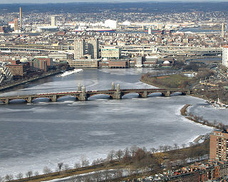
Brighton is a dissolved municipality and current neighborhood of Boston, Massachusetts, United States, and is located in the northwestern corner of the city. It is named after the town of Brighton in the English city of Brighton and Hove. For its first 160 years, Brighton was part of Cambridge, and was known as "Little Cambridge." Throughout much of its early history, it was a rural town with a significant commercial center at its eastern end. Brighton separated from Cambridge in 1807 after a bridge dispute, and was annexed to Boston in 1874. The neighborhood of Allston was also formerly part of the town of Brighton, but is now often considered separately, leading to the moniker Allston–Brighton for the combined area. This historic center of Brighton is the Brighton Center Historic District.
Allston is an officially recognized neighborhood of the City of Boston, Massachusetts. It was named after the American painter and poet Washington Allston. It comprises the land covered by the zip code 02134. For the most part, Allston is administered collectively with the adjacent neighborhood of Brighton. The two are often referred to together as "Allston–Brighton." Boston Police Department District D-14 covers the Allston-Brighton area and a Boston Fire Department Allston station is located in Union Square which houses Engine 41 and Ladder 14. Engine 41 is nicknamed "The Bull" to commemorate the historic stockyards of Allston.

Kenmore Square is a square in Boston, Massachusetts, United States, consisting of the intersection of several main avenues as well as several other cross streets, and Kenmore Station, an MBTA subway stop. Kenmore Square is close to or abuts Boston University and Fenway Park, and it features Lansdowne Street, a center of Boston nightlife, and the Citgo sign. It is also the eastern terminus of U.S. Route 20, the longest U.S. Highway.
Packard's Corner is located in Boston, Massachusetts at the intersection of Commonwealth Avenue and Brighton Avenue. Packard's Corner is serviced by the Packards Corner stop on the B Branch of the MBTA's Green Line, a light rail line that runs mostly above ground. According to the Brighton Allston Historical Society, the name comes from Packard's Sales Stable and Riding School which existed in the area from 1885 through 1920, and was perpetuated by the Packard automobile dealership that was built in 1910. The corner is also the former home of Maverick Designs, a longtime supplier of unfinished wood products.
Allston–Brighton is a set of two interlocking Boston neighborhoods, Allston and Brighton.

The Charles River Esplanade of Boston, Massachusetts, is a state-owned park situated in the Back Bay area of the city, on the south bank of the Charles River Basin.

Lechmere Canal is a short canal in East Cambridge, Massachusetts. It opens onto the Charles River and used to be an active port for Boston Harbor and the Atlantic Ocean.

The Muddy River is a series of brooks and ponds that runs through sections of Boston's Emerald Necklace, including along the south boundary of Brookline, Massachusetts. The river, which is narrower than most waterways designated as rivers in the United States, is a protected public recreation area surrounded by parks and hiking trails, managed by the Massachusetts Department of Conservation and Recreation.

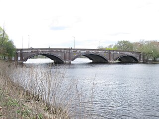
The River Street Bridge is a bridge connecting River Street in Cambridge, MA to Cambridge Street in Allston, Boston, MA. It was built in 1925 by the Commonwealth of Massachusetts Metropolitan District Commission.

The Western Avenue Bridge is a bridge carrying Western Avenue over the Charles River between Cambridge, Massachusetts and Allston, Boston. It was built in 1924 by the Commonwealth of Massachusetts Metropolitan District Commission.

The John W. Weeks Bridge, usually called the Weeks Footbridge, is a pedestrian bridge over the Charles River, connecting Cambridge, Massachusetts with the Allston neighborhood of Boston. John W. Weeks was a longtime U.S. Representative, and later Senator, from Massachusetts, as well as Secretary of War in the Harding and Coolidge administrations. The Weeks Bridge opened in 1927 to carry pedestrian traffic between the Harvard Business School's newly built Allston campus and the Business School's former home, Harvard's traditional campus in Cambridge. Its concrete underbelly conceals tentacles of the University's steam, electrical, and communications networks.
Harpers Ferry was a live music venue and bar in the Allston neighborhood of Boston, Massachusetts. It was in the high traffic central student section of Boston, equidistant from both Boston College and Boston University. Hosting national touring acts and regional acts, Harpers Ferry became known as "Boston's Best Live Music". The development of the "Allston Rock City" music scene centered on Harpers Ferry as a primary venue. Harpers Ferry closed down unexpectedly on October 31, 2010. The location is now home to the Brighton Music Hall.

The Arsenal Street Bridge is a bridge connecting Arsenal Street in Watertown, Massachusetts to Western Avenue in Allston, Boston, Massachusetts. It was built in 1925 by the Commonwealth of Massachusetts Metropolitan District Commission.

Soldiers Field Road is a major crosstown parkway in Boston, Massachusetts, running west to east from U.S. Route 20 in the northwest corner of Brighton to the Boston University Bridge. It follows the course of the Charles River and also passes by the campuses of Harvard University and Boston University. The road is named for the area south of the road on a bend in the Charles River which has been the home of Harvard Crimson athletics since the 1890s.

The Charles River Speedway was a former bicycle and harness racing track located in Allston, Massachusetts.

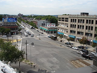
Union Square is a square in the Allston neighborhood of Boston, Massachusetts at the intersection of Cambridge Street and Brighton Avenue/North Beacon Street. Union Square is serviced by the MBTA 57, 64, 66, 501, and 503 buses. There is also a station for the Blue Bikes bicycle sharing system in Union Square.

Boston Landing is an MBTA Commuter Rail station in Boston, Massachusetts. It serves the Framingham/Worcester Line. It is located in the Brighton neighborhood just west of the Everett Street bridge, next to the Massachusetts Turnpike. It serves the Allston-Brighton area as well as the Boston Landing development including Warrior Ice Arena. The station is fully handicapped accessible, with a single full-length high-level island platform. Elevators and stairs lead to Arthur Street and to the Everett Street bridge.
The Brighton Stock Yards were stockyards located in Brighton, Boston. It operated across Market Street from the Brighton Abattoir, as cattle would be loaded into rail cars of the Boston and Albany Railroad and transported west.
The Brighton Abattoir was a slaughterhouse located in Brighton, Boston. It operated across Market Street from the Brighton Stock Yards, as cattle would be located into rail cars of the Boston and Albany Railroad and transported west from the yards.

Beacon Park Yard was a CSX Transportation rail yard in Allston, Boston, now owned by Harvard University. The yard opened in 1890 on the site of a former trotting park, from which it took its name. It was closed in 2013 following the relocation of the yard's container operations to Worcester, Massachusetts and opening of a transload facility in Westborough, Massachusetts. Plans for the yard include relocation of the Massachusetts Turnpike Allston exit, construction of a new MBTA commuter rail station and layover yard, and a major real estate development.