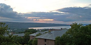
Cayuga Lake is the longest of central New York's glacial Finger Lakes, and is the second largest in surface area and second largest in volume. It is just under 39 miles (63 km) long. Its average width is 1.7 miles (2.8 km), and it is 3.5 mi wide (5.6 km) at its widest point, near Aurora. It is approximately 435 ft deep (133 m) at its deepest point, and has over 95 miles (153 km) of shoreline.

The Finger Lakes are a group of eleven long, narrow, roughly north–south lakes located directly south of Lake Ontario in an area called the Finger Lakes region in New York, in the United States. This region straddles the northern and transitional edge of the Northern Allegheny Plateau, known as the Finger Lakes Uplands and Gorges ecoregion, and the Ontario Lowlands ecoregion of the Great Lakes Lowlands.
Owasco is a town in Cayuga County, New York, United States. It is part of the traditional territory of the Cayuga nation. The population was 3,793 at the 2010 census. Owasco is in the eastern part of Cayuga County and is at the southeast city line of Auburn. The town borders Owasco Lake, from where it gets its name.

Springport is a town in Cayuga County, New York, United States. The population was 2,367 at the 2010 census. The name is derived from the local springs and lakeports. Springport is on the western border of the county and is southwest of Auburn.

The Mohawk River is a 149-mile-long (240 km) river in the U.S. state of New York. It is the largest tributary of the Hudson River. The Mohawk flows into the Hudson in Cohoes, New York, a few miles north of the state capital of Albany. The river is named for the Mohawk Nation of the Iroquois Confederacy. A major waterway, in the early 19th century, the river's east-west valley provided the setting and water for development of the Erie Canal, as a key to developing New York. The largest tributary, the Schoharie Creek, accounts for over one quarter (26.83%) of the Mohawk River's watershed. Another main tributary is the West Canada Creek, which makes up for 16.33% of the Mohawk's watershed.

The Cayuga are one of the five original constituents of the Haudenosaunee (Iroquois), a confederacy of Native Americans in New York. The Cayuga homeland lies in the Finger Lakes region along Cayuga Lake, between their league neighbors, the Onondaga to the east and the Seneca to the west. Today, Cayuga people belong to the Six Nations of the Grand River First Nation in Ontario, and the federally recognized Cayuga Nation of New York and the Seneca-Cayuga Tribe of Oklahoma.

The Seneca River flows 61.6 miles (99.1 km) through the Finger Lakes region of Upstate New York in the United States. The main tributary of the Oswego River – the second-largest river flowing into Lake Ontario – the Seneca drains 3,468 square miles (8,980 km2) in parts of fourteen New York counties. The Seneca flows generally east, and is wide and deep with a gentle gradient. Much of the river has been channelized to form part of the Erie Canal.

The Sacandaga River is a 64-mile-long (103 km) river in the northern part of New York in the United States. Its name comes from the Native American Sa-chen-da'-ga, meaning "overflowed lands".

Goiogouen, was a major village of the Cayuga nation of Iroquois Indians in west-central New York State. It was located on the eastern shore of Cayuga Lake on the north side of the Great Gully Brook, about 10 miles (16 km) south of the large 17th-century Cayuga town of Tiohero; and approximately along the southern line of the modern-day township of Springport, New York. It was located about four miles (6 km) north from Chonodote, the present-day location of the village of Aurora, New York and about two miles (3 km) south of the village of Union Springs, New York.
Cayuga Creek is a small stream in western New York, United States, with stretches in both Erie County and Wyoming County. The creek enters Buffalo Creek in the northwest corner of the Town of West Seneca in Erie County, just upstream from the New York State Thruway crossing. At that point, Buffalo Creek becomes the Buffalo River and flows into Lake Erie near Buffalo, New York.
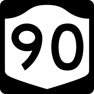
New York State Route 90 (NY 90) is a north–south state highway in the Finger Lakes region of New York in the United States. All but five of the route's 53 miles (85 km) are located in Cayuga County, with the remaining 5 miles (8 km) situated in Cortland County. The southern terminus of the route is at an intersection with U.S. Route 11 (US 11) and NY 41 in the village of Homer. Its northern terminus is at a junction with NY 31 in the town of Montezuma. Although the route is signed as north–south, the portion of NY 90 from King Ferry to Homer follows an east–west alignment.

New York State Route 34B (NY 34B) is a north–south state highway located within Tompkins and Cayuga counties in Central New York in the United States. Its northern terminus is located at a junction with NY 34 by the hamlet of Fleming within the town of the same name in Cayuga County. The southern terminus is located at a junction with NY 38 in the town of Dryden in Tompkins County.
Sucker Brook is a short stream that drains into the northwest corner of Canandaigua Lake, New York, United States. It flows in a 6-mile (9.7 km) hairpin-shaped course from uplands in the town of Canandaigua to the lake, in the eponymous city. The name comes from the white sucker fish abundant in its waters.
Williams Brook is a river located in Tompkins County, New York. It flows into Cayuga Lake by Ithaca, New York.
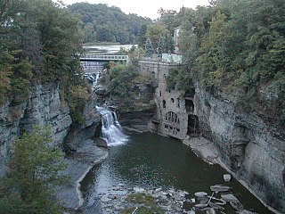
Fall Creek is a river located in Tompkins County, New York. It flows into Cayuga Lake by Ithaca, New York.
Minnegar Brook is a river located in Tompkins County, New York. It flows into Cayuga Lake by Myers, New York.
Yawger Creek is a river located in Cayuga County, New York. It flows into Cayuga Lake south of Cayuga, New York.
Lick Brook is a small stream located in Tompkins County, New York. It flows into Cayuga Inlet south of Ithaca, New York.
Cliff Park Brook is a river located in Tompkins County, New York. It flows into Cayuga Inlet by Ithaca, New York.

