Related Research Articles

Grenada is an island country located between the Caribbean Sea and Atlantic Ocean, north of Trinidad and Tobago. It is located at 12°07′N61°40′W. There are no large inland bodies of water on the island, which consists entirely of the state of Grenada. The coastline is 121 km long. The island has 15 constituencies and speaks English and Grenadian Creole. It is volcanic in origin and its topography is mountainous.

St. George's is the capital of Grenada. The town is surrounded by a hillside of an old volcano crater and is located on a horseshoe-shaped harbour.
The Udzungwa Mountains are a mountain range in south-central Tanzania. The mountains are mostly within Iringa Region, south of Tanzania's capital Dodoma. The Udzungwa Mountains are part of the Eastern Arc Mountains, and are home to a biodiverse community of flora and fauna with large numbers of endemic species.

Grenada is an island country of the West Indies in the eastern Caribbean Sea. The southernmost of the Windward Islands, Grenada is directly south of Saint Vincent and the Grenadines and about 100 miles (160 km) north of Trinidad and the South American mainland.
Bradt Travel Guides is a publisher of travel guides founded in 1974 by Hilary Bradt and her husband George, who co-wrote the first Bradt Guide on a river barge on a tributary of the Amazon.
Alam-Pedja Nature Reserve is the largest nature reserve in Estonia. It is a vast wilderness area which covers 342 km2 and consists of a complex of 5 large bogs separated by unregulated rivers, their floodplains, and extensive forests. The nature reserve aims to protect diverse ecosystems and rare species, mainly through preserving the natural development of forests and bogs and securing the continuing management of semi-natural floodplain grasslands.

Grand Etang Lake is a crater lake in an extinct volcano which hasn't erupted in 12,000 years. It is located on the island of Grenada, in Saint Andrew Parish. The Grand Etang Lake is 530 m (1,740 ft) above sea level and it is one of the two crater lakes on the island. The lake is approximately 20 ft (6.1 m) deep and 36 acres (15 ha) in area and is also rumored to be home to a mermaid living in the depths that lure men to their watery grave.

The Pagua River is one of the longest rivers on the Caribbean island of Dominica. It originates in the D'Leau Gommier area of the Central Forest Reserve, where it shares the same watershed as the Layou River. The Pagua flows northeastward, forming the western boundary of the Carib Territory. It empties into the Atlantic Ocean in Pagua Bay, on Dominica's east coast.
The Grand Bras River is a river of Grenada.
The Grand Roy River is a river of Grenada.
The Great Palmiste River is a river of Grenada. It's in the west part of the country, 9 kilometers north of Saint George.
The River Loria is a river of Grenada.
The River Simon is a river of Grenada in Saint Andrew Parish, Grenada.
The Katonga Wildlife Reserve is a wildlife reserve in western Uganda, along the banks of the Katonga River. The reserve was established in 1998 and has approximately 211 square kilometres (81 sq mi). Many of the species of plants and animals in the reserve are unique to its wetland environment. Additionally the grass species at Katonga Wildlife Reserve include star grass, Bermuda grass and Rhodes grass.
The Kabwoya Wildlife Reserve is a reserve in Uganda. It was established in 1980, and covers 8,700 square kilometres (3,400 sq mi).
The Chad Basin National Park is a national park in northeastern Nigeria, in the Chad Basin, with a total area of about 2,258 km2. The park is fragmented, with three sectors. The Chingurmi-Duguma sector is in Borno State, in a Sudanian savanna ecological zone. The Bade-Nguru Wetlands and Bulatura sectors are in Yobe State in the Sahel ecological zone.

The Semliki Wildlife Reserve is a conservation protected area in the Western Region of Uganda with headquarters at Karugutu in Ntoroko District.It is the oldest wildlife reserve.

The Immaculate Conception Cathedral is a religious building belonging to the Catholic Church and is located on Church Street beside York House in the town of Saint George, capital of the Caribbean island nation of Grenada in the Lesser Antilles.

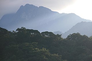
The Mount St. Catherine Forest Reserve is the second largest declared terrestrial protected area in Grenada after the Grand Etang and Annandale Forest Reserves. Covering 934 ha within a 31.7 km (19.7 mi) boundary perimeter, its headwaters drain across seven of the largest watersheds on the island and supply important catchment basins for water distribution to Grenadians and agrarian landscapes downstream. The forest reserve encompasses the principal peak of the Mount Saint Catherine massif—the highest point on the island 840 m (2,760 ft), as well as other lushly forested ridges and lesser peaks, the highest waterfall in the country, the majority of the island's known hot springs, including the hottest geothermal spring and its most accessible geothermal bathing pool.

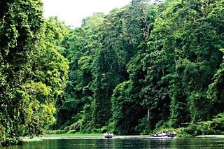
The Grand Etang and Annandale Forest Reserves are contiguous protected areas located in the south central interior mountains of Grenada. Together they encompass the largest declared terrestrial protected area in Grenada followed by the Mount St. Catherine Forest Reserve. The Grand Etang and Annandale Forest Reserves are managed together.
References
- 1 2 3 Crask, Paul (2009). Grenada, Carriacou, Petite Martinique: The Bradt travel guide. Chalfont St. Peter, England: Bradt Travel Guides. p. 73. ISBN 9781841622743.
- ↑ "Grand Etang National Park & Forest Reserve". Pure Grenada. Grenada Tourism Authority. Retrieved 27 July 2024.