
Great Sandy National Park is a coastal national park in the Fraser Coast Region, Queensland, Australia.

Fraser Island, officially K'gari, is a World Heritage-listed sand island along the south-eastern coast in the Wide Bay–Burnett region, Queensland, Australia. The island is approximately 250 km (160 mi) north of the state capital, Brisbane, and is within the Fraser Coast Region local government area. The world heritage listing includes the island, its surrounding waters and parts of the nearby mainland which make up the Great Sandy National Park. In the 2021 census, the island had a population of 152 people. Up to 500,000 people visit the island each year.

The Montebello Islands, also rendered as the Monte Bello Islands, are an archipelago of around 174 small islands lying 20 km (12 mi) north of Barrow Island and 130 km (81 mi) off the Pilbara coast of north-western Australia. The islands form a marine conservation reserve of 58,331 ha administered by the Western Australian Department of Environment and Conservation. The islands were the site of three British atmospheric nuclear weapons tests in 1952 and 1956.

The Coral Sea is a marginal sea of the South Pacific off the northeast coast of Australia, and classified as an interim Australian bioregion. The Coral Sea extends 2,000 kilometres (1,200 mi) down the Australian northeast coast. Most of it is protected by the French Natural Park of the Coral Sea and the Australian Coral Sea Marine Park. The sea was the location for the Battle of the Coral Sea, a major confrontation during World War II between the navies of the Empire of Japan, and the United States and Australia.

The nankeen kestrel, also known as the Australian kestrel, is a raptor native to Australia and New Guinea. It is one of the smallest falcons, and unlike many, does not rely on speed to catch its prey. Instead, it simply perches in an exposed position, but it also has a distinctive technique of hovering over crop and grasslands.
Moreton Bay is a locality split between the City of Brisbane and the City of Redland, both in Queensland, Australia. The locality includes all of the bay Moreton Bay between the mainland of the City of Brisbane and the City of Redland across to the western coast of Moreton Island and the western coast of North Stradbroke Island. In the 2021 census, Moreton Bay had a population of 0 people.

The Australian Indian Ocean Territories is the name since 1995 of an administrative unit under the Australian Department of Infrastructure, Transport, Regional Development, Communications and the Arts, consisting of two island groups in the Indian Ocean under Australian sovereignty:

The Great Sandy Strait is a strait in the Australian state of Queensland of 70 kilometres (43 mi) length which separates mainland Queensland from Fraser Island. It is also a locality in the Fraser Coast Region local government area. In the 2021 census, Great Sandy Strait had a population too low to be reported. To the north of the strait is Hervey Bay.

River Heads is a coastal town and locality in the Fraser Coast Region, Queensland, Australia. In the 2021 census, the locality of River Heads had a population of 2,044 people.

Tin Can Bay is a coastal town and locality in the Wide Bay–Burnett region in Queensland, Australia. The locality is split between the Fraser Coast Region and the Gympie Region, but the town itself is within Gympie Region. In the 2016 census, Tin Can Bay had a population of 2,242 people.
Gunna is an island in the Inner Hebrides of Scotland.
The Rudall River is an ephemeral river in the Pilbara region of Western Australia. The entire length of the river is located within the boundaries of the Karlamilyi National Park, which straddles the Little Sandy Desert (LSD) and the Great Sandy Desert (GSD).
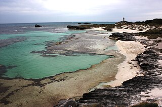
The Basin is a popular swimming location on Rottnest Island, Western Australia. It is located at 31°59′21″S115°32′9″E, in the northwest of the island, between Pinky Beach and Longreach Bay.

The Great Sandy-Tanami desert is a ecoregion of Western Australia extending into the Northern Territory. It is designated as a World Wildlife Fund region.

Sandy Cape is the most northern point on Fraser Island off the coast of Queensland, Australia. The place was named Sandy Cape for its appearance by James Cook during his 1770 voyage up the eastern coast of Australia aboard the Endeavour. To the south the next two ocean headlands are Waddy Point and Indian Head.

Urangan is a coastal suburb of the city of Hervey Bay in the Fraser Coast Region, Queensland, Australia. In the 2016 census Urangan had a population of 9,764 people.

Wide Bay–Burnett is a region of the Australian state of Queensland, located between 170–400 km (110–250 mi) north of the state capital, Brisbane. The area's population growth has exceeded the state average over the past 20 years, and it is forecast to grow to more than 430,000 by 2031. It is the subject of the Draft Wide Bay–Burnett Regional Plan, which aims to facilitate this growth while protecting over 90% of the region from urban development.
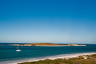
Lancelin Island is an island in Western Australia near Lancelin.
Quagering Island is an island off the south coast of Western Australia, located near Windy Harbour, and along with Sandy Island makes the Quagering Nature Reserve.

Hervey Bay is a bay of the Coral Sea in the Bundaberg Region and Fraser Coast Region of Queensland, Australia. The bay covers 4,000 square kilometres (1,500 sq mi) with a main opening facing northwards. The northern end of the bay is about 80 km wide and its average depth is about 20 metres. In the south of the bay lies the Great Sandy Strait. The Mary River, Burrum River and Burnett River flow into the bay. Hervey Bay is partly protected from oceanic swells by the southern extension of the Great Barrier Reef. To the east of the bay is Fraser Island.
