New Orleans Public Schools (NOPS) is the public school system that serves all of New Orleans, Louisiana, United States. Schools within the system are governed by a multitude of entities, including the Orleans Parish School Board (OPSB), which directly administers 6 schools and has granted charters to another 18, and the Recovery School District of Louisiana (RSD), which no longer directly administers any schools within Orleans Parish. Instead, all public schools operating under the RSD umbrella within Orleans Parish are, as of the Fall of 2014, independent public charter schools. Though the Orleans Parish School Board has retained ownership of all the assets of the New Orleans Public Schools system, including all school buildings, approximately 93% of students attending public schools in Orleans Parish now attend independent public charter schools – the highest percentage in the nation. The headquarters of the OPSB is in the West Bank neighborhood of Algiers, while the RSD's New Orleans office is on Poydras Street in the CBD.
Elysian Fields Avenue is a broad, straight avenue in New Orleans named after the Avenue des Champs-Élysées in Paris. It courses south to north from the Lower Mississippi River to Lake Pontchartrain, a distance of approximately 5 miles (8.0 km). The avenue intersects with Interstate 610, Interstate 10, and U.S. Highway 90, Gentilly Boulevard passing by Brother Martin High School. The part between North Claiborne Avenue and Gentilly Boulevard is Louisiana Highway 3021 ; the piece from N. Claiborne Avenue south to St. Claude Avenue carries Louisiana Highway 46.
Milneburg is a neighborhood of the city of New Orleans. A subdistrict of the Gentilly District Area, its boundaries as defined by the City Planning Commission are: Leon C. Simon Drive to the north, People's Avenue to the east, Filmore Avenue to the south and Elysian Fields Avenue to the west, putting it within the 8th Ward of New Orleans. The Milneburg neighborhood takes its name from Milneburg, a historic town and neighborhood formerly located a short distance north of the modern neighborhood.
The United Teachers of New Orleans (UTNO) is a labor union representing teachers and other educational workers in New Orleans, Louisiana, United States. It is an affiliate of the Louisiana Federation of Teachers (LFT), American Federation of Teachers (AFT) and the AFL-CIO.

Hollygrove is a neighborhood of the city of New Orleans, Louisiana, located in the city's 17th Ward. A subdistrict of the Uptown/Carrollton area, its boundaries as defined by the City Planning Commission are: Palmetto Street to the north, Cambronne, Edinburgh, Forshey, Fig and Leonidas Streets to the east, Earhart Boulevard to the south and the Jefferson Parish boundary to the west. Conrad playground, the Cuccia-Byrnes playground and Larry Gilbert baseball stadium are located in Hollygrove. The Hollygrove Market and Farm is also located in Hollygrove. Notable people, including rapper Lil Wayne, have grown up in the neighborhood.

Gentilly Woods is a neighborhood of the city of New Orleans. A subdistrict of the Gentilly District Area, its boundaries as defined by the City Planning Commission are: Dreux Avenue to the north, Industrial Canal to the east, Gentilly Boulevard to the south and People's Avenue to the west.
Recovery School District (RSD) is a special statewide school district administered by the Louisiana Department of Education. Created by legislation passed in 2003, the RSD is designed to take underperforming schools and transform and make them effective in educating children. While the majority of RSD-supervised schools are within New Orleans and were largely under the administration of the Orleans Parish School Board pre-Katrina, the RSD has also taken over schools in East Baton Rouge, Caddo and Pointe Coupee parishes, reflecting its statewide authority and full name, the Recovery School District of Louisiana (RSDLA). As of 2012 it is the fifth largest school district in Louisiana by student population.

Lower Garden District is a neighborhood of the city of New Orleans. A subdistrict of the Central City/Garden District Area, its boundaries as defined by the City Planning Commission are: St. Charles Avenue, Felicity, Prytania, Thalia, Magazine, and Julia Streets to the north; the New Orleans Morial Convention Center, Crescent City Connection, and Mississippi River to the east; Felicity Street, Magazine Street, Constance Street, Jackson Avenue, Chippewa Street, Soraparu Street, and St. Thomas Street to the south; and 1st Street to the west.

Gentilly Terrace is a neighborhood of the city of New Orleans. A subdistrict of the Gentilly District Area, its boundaries as defined by the City Planning Commission are: Filmore Avenue to the north, People's Avenue to the east, Dahlia Walk and Benefit Street to the south and Elysian Fields Avenue to the west. Gentilly Terrace may be further divided into Gentilly Terrace & Gardens, Edgewood Park and Fairmont Park, all three of which possess organized, distinct, and active neighborhood associations.
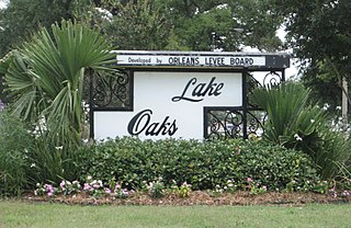
Lake Terrace/Lake Oaks is a neighborhood of the city of New Orleans, Louisiana. A sub-district of the city's Gentilly District, its boundaries as defined by the City Planning Commission are: Lake Pontchartrain to the north; the Industrial Canal to the east; Leon C. Simon Drive, Elysian Fields Avenue, New York Street, the London Avenue Canal, and Robert E. Lee Boulevard to the south; and Bayou St. John to the west. The neighborhood comprises the Lake Terrace and Lake Oaks subdivisions, the principal campus of the University of New Orleans, and the University of New Orleans Research & Technology Park — all built on land reclaimed from Lake Pontchartrain.
St. Anthony is a neighborhood of the city of New Orleans. A subdistrict of the Gentilly District Area, its boundaries as defined by the City Planning Commission are: New York Street to the north, Elysian Fields Avenue to the east, Mirabeau Avenue to the south and the London Avenue Canal to the west.

Desire Area is a neighborhood of the city of New Orleans. A subdistrict of the Bywater District Area, its boundaries as defined by the City Planning Commission are: Gentilly Boulevard to the north; the Industrial Canal to the east; Florida Boulevard, Alvar Street, Higgins Boulevard, Piety Street, Pleasure Street, Oliver White Avenue, and Desire Street to the south; and People's Avenue to the west. It is part of the Upper 9th Ward.
Abramson Sci Academy is a high school in the New Orleans East area of New Orleans, United States.
The Abramson Science and Technology Charter School was a charter school in New Orleans, Louisiana. As of 2013 it is directly operated by the Recovery School District (RSD) and is a K-8 school. It previously served grades K-11 and was managed by the Pelican Educational Foundation on behalf of the RSD. It is located on the site of the former Marion Abramson High School in New Orleans East. It is adjacent to the campus of the Sarah T. Reed Elementary School.
Cohen College Prep High School is a New Orleans college prep high school serving 9th through 12th grade students in Uptown New Orleans, Louisiana, United States. It is named after Walter L. Cohen, a free man of color who became the Registrar of the U.S. Land Office.

The International School of Louisiana (ISL) is a system of charter schools in Greater New Orleans. Two campuses are in New Orleans and one campus is in Metairie. The K-8 school offers a French immersion program and a Spanish immersion program. As of 2007 it was one of two New Orleans schools chartered by the State of Louisiana that is not a part of the Recovery School District (RSD).
George Washington Carver Senior High School was a high school in the Desire Area, in the Ninth Ward of New Orleans. It was previously operated by New Orleans Public Schools, then Recovery School District. It is currently home to George Washington Carver Collegiate Academy (CCA) and George Washington Carver Preparatory Academy (CPA), two charter high schools operated by Collegiate Academies.