Green Belt of Vitoria-Gasteiz

Last updated
Salburua Vitoria 05 2012 Anillo Verde 1922.JPG
Salburua

The Green Belt of Vitoria-Gasteiz is a set of urban parks with high ecological value, strategically linked by eco-recreational corridors. It is the result of an ambitious plan of restoration and reclamation on the outskirts of the city that seeks to recover the ecological and social value of this space through the creation of a nature tour around the city articulated by various enclaves of high ecological value and landscape. It is the result of a project which began in the early 1990s and was selected by the UN among the 100 best global performances of the III International Competition "Best Practices for improving the living conditions of the cities", held in Dubai in the year 2000. Currently, it has five established parks: Armentia, Olarizu, Salburua, Zabalgana and Zadorra. [1]

Contents

History

Casa de la Dehesa, seat of the Environmental Studies Center Olarizu - Casa de la Dehesa 02.jpg
Casa de la Dehesa, seat of the Environmental Studies Center

The idea of the Green Belt came in the early 1990s in order to provide a comprehensive solution to the problems of the urban periphery of Vitoria-Gasteiz and the general state of disrepair that the area presented.

When the project began, on the outskirts of the city coexisted with high ecological value areas such as forests or Zabalgana Armentia that, although affected by problems of erosion, fire ... had managed to survive the urban and industrial expansion of the city, with gravel pits, dumps and other degraded sites that threatened the fragile survival of relict existing natural enclaves. The area offered a precarious and insecure to stay and ride, having become a physical and social barrier between the urban and rural adjacent.

To address existing problems and convert and / or enhance the value, if any, the suburbs, and residual clearly undervalued, Environmental Studies Center of the City of Vitoria-Gasteiz decided to undertake a large-scale project that encompasses all the periphery of the city and provide a solution to both areas operated as natural enclaves.

It was basically to create a network of suburban green spaces, an idea also found support and rationale within the management framework established by the General Urban Plan of 1986 that it proposed extending the system of urban green areas to areas peripherals.

Parks

Alegria

Situated between the river Zadorra and wetlands of Salburua, the river Alegría and its banks represent today an important ecological corridor between these two valuable ecosystems, allowing the movement of such representative species as the European mink. It is a space for leisure activities, which connects the periurban Salburua park with the future fluvial park of the river Zadorra, in the Gamarra area.

Armentia

Picnic site in the Armentia Forest Merendero Armentia 01.jpg
Picnic site in the Armentia Forest

This is a large natural oak forest, located between the city and the Mountains of Vitoria, the main mountain range and one of the most valuable natural areas in the municipality of Vitoria-Gasteiz. [2] Precisely its location makes the Forest of Armentia a real biological corridor between the forest areas, green areas and peri-urban ecosystem, and in this paper lies the main value Armentia Park.

Olárizu

Olarizu mountain, Casa de la Dehesa and Olarizu meadows Olarizu - Casa de la Dehesa 04.jpg
Olarizu mountain, Casa de la Dehesa and Olarizu meadows
Olarizu Meadows Vitoria - Campas de Olarizu 01.jpg
Olarizu Meadows
Deer in the Green Ring Cervus elaphus - Salburua.jpg
Deer in the Green Ring

The fields open stands of Olárizu, an iconic mountain and the many trails that run through there and connects the city with the nearby towns, make this park a popular spot that is ideal for walking or just stay (in authorized areas). [3] Unlike the other parks in the Green Belt, Olarizu Park has a "less natural" and closer to the typically urban park concept, as it is with this character as originally conceived. Created in 1984 to the mid-90 becomes part of the Green Belt. Since then, his conditioning has been directed mainly to public use and to accept training and environmental education. Included among the grounds the Botanical Garden Olárizu.

Salburua

Salburua a wetland formed by several lakes (Arcaute and Betoño are the main ones), along with spaces and a small oak empradizados. [4] The lakes dried centuries ago to transform the area into farmland, the restoration work started in 1994 have reversed this situation and now Salburua is one of the most valuable inland wetlands of the Basque Country and Ramsar Wetland of International Importance. The park can be visited through various routes that surround and connect major gaps. Facilities include the 'Interpretation Centre ATARIA' and two bird observatories.[ citation needed ]

Zabalgana

This park is the result of an intensive restoration process, which has become an area of old gravel pits, very degraded, in an area of natural interest suitable for leisure and recreation of the population. [5] In the park of Zabalgana there are alternating meadows, scattered woodlots, ponds, small hills and ridges, sitting areas, trails and natural forest gall; it is a forest-island surrounded by a sea of crops.

Zadorra

The Zadorra river runs along the north part of the city acting as a limit to the city's expansion. [6] Holder of important natural values that have motivated his statement as space SCI (Site of Community Interest) within the European Natura 2000 Network of Protected Natural Spaces, the Zadorra and its surroundings are an ideal space for walks. In the near future it will be possible[ speculation? ] to have an extensive river park 13 km long and a surface of 213 ha, which will act as a key link in the Green Ring, including wetlands and Salburua and Zabalgana.[ citation needed ]

Future expansions

Errekaleor

The future park is bounded on the south Olarizu Park and north to wetlands Salburua, being included within the new residential expansion Salburua. [7] Its location makes this place an important connecting element between the Green Belt parks located south and east of the city. The river Errekaleor ensure ecological connectivity while the Cerro de Las Neveras, noteworthy from the standpoint of landscape, will be included in the Green Belt as a promenade a must for great views. The design of this environment, which is provided as part of the redevelopment project of Salburua, will involve the expansion of the area of the Green Ring in 28 hectares.[ citation needed ]

Objectives

Maintenance

Green Belt trail marking Marca Anillo Verde 07.jpg
Green Belt trail marking

There is a permanent maintenance service in the Green Belt that monitors the state of conservation of the plants in the Parks including the mowing of grass and treed meadows, irrigation, digging, fertilising, hoeing, pruning, replacing dead plants, sowing and planting, as well as other related tasks.

There is also a service responsible for maintaining the equipment and signposting in the Green Belt. Its work includes ensuring that these are kept in the best possible state of conservation, as well as the repair, refitting and replacement of damaged equipment due to normal wear and tear or due to accidents or vandalism.

The overall maintenance of the Belt includes a general cleaning service that comprises the clearing of riverbanks after periods of flooding, the removal of rubbish and graffiti from signposts and equipment and other tasks.

See also

Related Research Articles

<span class="mw-page-title-main">Vitoria-Gasteiz</span> Municipality in Basque Country, Spain

Vitoria-Gasteiz, also alternatively spelled as Vittoria in old English-language sources, is the seat of government and the capital city of the Basque Country and of the province of Álava in northern Spain. It holds the autonomous community's House of Parliament, the headquarters of the Government, and the Lehendakari's official residency. The municipality—which comprises not only the city but also the mainly agricultural lands of 63 villages around—is the largest in the Basque Country, with a total area of 276.81 square kilometres (106.88 sq mi), and it has a population of 253,093. The dwellers of Vitoria-Gasteiz are called vitorianos or gasteiztarrak, while traditionally they are dubbed babazorros.

<span class="mw-page-title-main">Parelheiros (district of São Paulo)</span> District of São Paulo, Brazil

Parelheiros is one of 96 districts of the city of São Paulo. Located in the subprefecture of Parelheiros in the extreme south of the city, it is one of the largest and most rural districts. Very little of this area is inhabited, and is covered with reserves of the Atlantic Forest. In Parelheiros there are also two indigenous villages of a Guaraní subgroup with about one thousand residents. The region also received many German immigrants in the beginning of 1800. The inhabitants of the place have the lowest purchasing power of the city. The district is poorly served by public transport and roads; there is little connection to the central districts of the city.

<span class="mw-page-title-main">Desierto de los Leones National Park</span> National park in Mexico

Desierto de los LeonesNational Park is located entirely within the limits of the Federal District; it stretches between Cuajimalpa and Álvaro Obregón boroughs. It is located in the Sierra de las Cruces mountain range west of the city center with an area of 1,867 hectares, representing fifteen percent of the entire Valley of Mexico. The term Desierto (‘desert’) is used in this context in the archaic sense of “wild, sparsely populated area” rather than in reference to an arid environment. Leones (‘Lions’) refers not to the big cats but rather to the original landlord's surname.

The park of Armentia, commonly known as "El bosque de Armentia", is a gall-oak forest located between Vitoria-Gasteiz and the Mountains of Vitoria, in the province of Álava and of the autonomous community of the Basque Country in northern Spain. It has a surface area of 165 has and it is one of the main biological areas in the surroundings because it has a variety of flora and fauna.

<span class="mw-page-title-main">La Florida (park)</span>

La Florida is a park in Vitoria-Gasteiz, Álava, Spain. It was built between 1820 and 1855 in neoclassical style by the architects Angel Chavez, Juan De Velasco, Ramón Ortés De Velasco and Manuel Arana. The birth of Florida is dated 1820 when they built the existing ring that surrounds the music kiosk. For the actual 32,454 square meters land used the former convent of Santa Clara, and as much as planners have insisted later, there is nothing similar in the new green spaces in Vitoria.

<span class="mw-page-title-main">Salburua</span> Wetland in Vitoria-Gasteiz, Basque Country, Spain

Salburua is a wetland habitat on the eastern outskirts of the city of Vitoria-Gasteiz in the Basque Country in Spain. The area, which is part of the city green belt, contains lakes, meadows and oak groves. It was drained in the 19th century to transform the area into farmland. Restoration work started in 1994 and has reversed this situation and now Salburua is a Ramsar Wetland of International Importance. The Salburua marshes are considered to be "the Basque country's most valuable area of wetland", according to a Fedenatur report for the European Commission in 2004.

Arriaga-Lakua was a Spanish village in Álava, Basque Country and is at present one quarter of Vitoria-Gasteiz.

Tourism in the Basque Autonomous Community has increased considerably in recent years. According to data from the Eustat the number of tourists entering the region in the year 2009 was 1,991,790, with the final result still pending. 71% of the yearly visitors come from the rest of Spain; the greatest number from Madrid Autonomous Community (14.2%), and Catalonia (11.1%). International visitors make up the remaining 29% - the largest percent come from France (7.2%). 62% of the people who come to the Basque Autonomous Community visit one of the three capitals, 27% visit inland and 11% visit the coast. The average stay of the visitors is 2 days.

<span class="mw-page-title-main">Ataria</span>

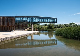
Ataria Interpretation Centre is a wetlands interpretation centre and natural history museum for the Salburua wetlands, a Ramsar site and a significant wetlands habitat in the Basque Autonomous Community. The wetlands region is an important green belt on the eastern outskirts of the city of Vitoria - Gasteiz in Álava-Araba province. Ataria showcases the value of the wetlands, which are classified as a class 1 Habitat of European Community Interest, and the importance of biodiversity to Vitoria-Gasteiz's natural heritage. The Salburua marshes are considered to be "the Basque country's most valuable area of wetland", according to a Fedenatur report for the European Commission in 2004.

<span class="mw-page-title-main">Armentia</span> Village in Basque Country, Spain

Armentia is one of the villages associated with Vitoria-Gasteiz. Its name comes from the Latin word armentum, which translated into English means "intensive farming". The village is well known for its 161ha park created in the 1998.

<span class="mw-page-title-main">TUVISA</span> Company

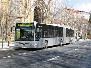
TUVISA is the municipal company responsible for urban transport in the city of Vitoria-Gasteiz, in the north of Spain. As of March 2022, the company operates 97 buses.

<span class="mw-page-title-main">Ullíbarri-Gamboa Reservoir</span> Reservoir in the Basque Country, Spain

The Ullíbarri-Gamboa Reservoir (Basque: Uribarri Ganboako urtegia, Spanish: Embalse de Ullíbarri-Gamboa) is located in Álava, Basque Country, Spain. With a total capacity of 147.2 hm3 (5.20×10⁹ cu ft), it is the largest reservoir in the Basque Country. Together with the nearby Urrunaga Reservoir, it provides water to the nearby city of Vitoria-Gasteiz and to Bilbao and its metropolitan area. The whole reservoir has been designated as a Natura 2000 site, and the southeastern end of the reservoir is also protected as a Ramsar wetland. It is also a popular leisure area, particularly for hiking and bathing.

FEDENATUR is an association of natural, fluvial and agricultural parks located in metropolitan and periurban areas in Europe. It is headquartered in the Serra de Collserola Natural Park in Barcelona.

<span class="mw-page-title-main">Marismas de Isla Cristina</span>

The Marismas de Isla Cristina are located at the mouth of the river Carreras in the province of Huelva, Andalusia, in southern Spain. Created in 1989, the natural park has a surface area of 21.45 square kilometres (8.28 sq mi), shared between the municipalities of Ayamonte and Isla Cristina.

<span class="mw-page-title-main">Pilancones</span>

Pilancones Natural Park is located in San Bartolomé de Tirajana municipality on the island of Gran Canaria, Spain. Its area is 5794.4 ha. It adjoins Roque Nublo country park to the north, and Fataga protected area to the east. The park plays an important role in soil protection and the replenishment of an aquifer, along which there are several ravines running southward which are of geomorphological interest and landscape value. The pine forests on hilltops are a well-preserved habitat with abundant bird life. The park also harbours several varieties of cactus and spurge, and a number of aquatic habitats. The park takes its name from natural pools, formerly known locally as pilancones, which remain after the runoff of water. Throughout the area there are threatened animal and plant species, and features of scientific interest.

<span class="mw-page-title-main">Ariznavarra</span> Place

Ariznavarra is a neighbourhood in Vitoria-Gasteiz, Spain, in the southwest of the city.

<span class="mw-page-title-main">Errekaleor</span> Squatted zone in Basque country

Errekaleor is a neighbourhood on the periphery of Vitoria-Gasteiz, in the Basque Country, Spain. It sits on the plateau created by the Errekaleor river, which is part of the Green Belt of Vitoria-Gasteiz. From 2013 onwards, the area was occupied by squatters and became known as Errekaleor Bizirik. The project is based on the principles of workers' self-management, consensus based decision making, feminism, anti-capitalism and Basque cultural re-invigoration. The neighbourhood is the largest occupied space of its type on the Iberian Peninsula, with over 10 hectares of land and 150 inhabitants. Residents include children, the elderly, blue-collar workers, the unemployed, students, and teachers. The project includes an organic farm of 2 hectares, a bakery, a bar, a social centre, a library, a theatre, a free shop, a recording studio, and other projects.

The Betoño Sports Complex, also known as El Glorioso, is a football training ground and match venue located in the city of Vitoria-Gasteiz, Álava.

The Ciudad Deportiva José Luis Compañón, also known as Instalaciones de Ibaia after the name of its semi-rural location, is the primary training ground of Spanish professional football club Deportivo Alavés, located in the city of Vitoria-Gasteiz, Álava.

<span class="mw-page-title-main">Vitoria-Gasteiz railway station</span>

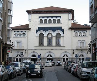
Vitoria-Gasteiz railway station is the main railway station in the Basque capital city of Vitoria-Gasteiz in Spain.

References