
The Arabian Sea is a region of sea in the northern Indian Ocean, bounded on the west by the Arabian Peninsula, Gulf of Aden and Guardafui Channel, on the northwest by Gulf of Oman and Iran, on the north by Pakistan, on the east by India, and on the southeast by the Laccadive Sea and the Maldives, on the southwest by Somalia. Its total area is 3,862,000 km2 (1,491,000 sq mi) and its maximum depth is 4,652 meters. The Gulf of Aden in the west connects the Arabian Sea to the Red Sea through the strait of Bab-el-Mandeb, and the Gulf of Oman is in the northwest, connecting it to the Persian Gulf.
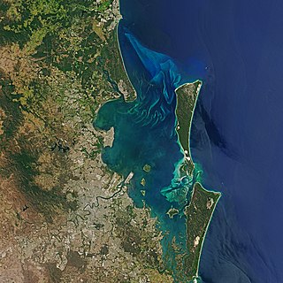
Moreton Bay is a bay located on the eastern coast of Australia 14 kilometres (8.7 mi) from central Brisbane, Queensland. It is one of Queensland's most important coastal resources. The waters of Moreton Bay are a popular destination for recreational anglers and are used by commercial operators who provide seafood to market.

Brisbane Water is a wave-dominated barrier estuary located in the Central Coast region of New South Wales, Australia. Brisbane Water has its origin at the confluence of the Narara and Coorumbine Creeks, to the south–east of Gosford and travels for approximately 18 kilometres (11 mi) in a southerly direction to its mouth at Broken Bay, about 7 kilometres (4.3 mi) from the Tasman Sea, at Barrenjoey Head. A number of towns and suburbs surround the shores of Brisbane Water, including Blackwall, Booker Bay, Davistown, Empire Bay, Erina, Ettalong Beach, Gosford, Green Point, Hardys Bay, Kilcare, Kincumber, Koolewong, Phegans Bay, Point Frederick, Point Clare, Saratoga, Tascott, Wagstaffe, and Woy Woy. Contained within Brisbane Water is St Huberts Island, Rileys Island, Dunmar Island and Pelican Island; and adjoining the estuary is Brisbane Water National Park to the west and Bouddi National Park to the east. Forming part of the same tidal estuary system is a separate but connected basin, the Kincumber Broadwater, lying to the east of Davistown.

Hildasay, also known as Hildisay, is an uninhabited island off the west coast of the Shetland Mainland.

The Tweed River is a river situated in the Northern Rivers region of New South Wales, Australia. From the middle reaches of its course, the state boundary between New South Wales and Queensland is located approximately 10 kilometres (6.2 mi) north.
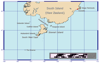
Foveaux Strait is a strait that separates Stewart Island from the South Island of New Zealand. The width of the strait ranges from about 23 to 53 km and the depth varies between 18 and 46 m. Captain James Cook passed around the southern tip of Stewart Island during his circumnavigation of the South Island in 1770 but did not record the presence of a seaway between Stewart Island and the mainland. The strait was not charted until 1804 when an American sealer, Owen Folger Smith, mapped it.
Green Island or Greene Island can refer to:
Ruapuke Island is one of the southernmost islands in New Zealand's main chain of islands. It lies 15 kilometres (9.3 mi) to the southeast of Bluff and 32 kilometres (20 mi) northeast of Oban on Stewart Island/Rakiura. It was named "Bench Island" upon its discovery by Captain James Cook in 1770, but has rarely been known by any other name than its Māori name, which means "two hills". Ruapuke Island was called Goulburn Island by Captain John Kent, named after Frederick Goulburn, a Government official in New South Wales, but the whalers generally called it Long Island, or Robuck. The island covers an area of about 16 km2 (6 sq mi). It guards the eastern end of Foveaux Strait.
Aotea Harbour is a settlement and smallest of three large natural inlets in the Tasman Sea coast of the Waikato region of New Zealand's North Island. It is located between Raglan Harbour to the north and Kawhia Harbour to the south, 30 kilometres southwest of Hamilton.
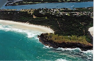
Fingal Head is a village on the Tasman Sea coast in the far northeast of New South Wales, Australia, about 5 km south of the New South Wales and Queensland border. The village is often just called Fingal. The headland and the small off-shore Island were first sighted by James Cook about 17:00 on 16 May 1770. At the time of the 2021 census, Fingal Head had a population of 592 people.

Smoky Cape is a headland in Australia on the New South Wales Mid-North Coast. It lies just east of the town of South West Rocks, and within the Hat Head National Park.

Ruapuke is a small farming community in the Waikato region on the slopes of Karioi, between Raglan and Kawhia in New Zealand.

The South Devon National Landscape covers 337 square kilometres, including much of the South Hams area of Devon and the rugged coastline from Jennycliff Bay to Elberry Cove near Brixham. The purpose of an Area of Outstanding Natural Beauty is to conserve and enhance the area's natural beauty. In South Devon this includes: undeveloped coastline, estuaries, geological and geomorphological features, expansive panoramic views, ancient agricultural field pattern, Devon banks, areas of high tranquility, dark night skies and natural nightscapes, historic features, green lanes, well known cultural associations, picturesque villages and hamlets. South Devon AONB was formally designated in August 1960 under the National Parks and Access to the Countryside Act 1949. The highest point in the AONB is Blackdown Camp at 199 metres above sea level.
Hummock Island is the largest of a group of islands in King George Bay in the Falkland Islands. It has a land area of 3.03 square kilometres (1.17 sq mi) and is about 4.0 miles (6.4 km) long in a north-west to south-east direction. Hummock Island is off the western coast of West Falkland, in a bay that leads to the estuary of the Chartres River. The highest point on the island is in the north-east and is 190 metres (620 ft). There are cliffs which often reach over 60 metres (200 ft) high.
His Majesty's colonial brig Elizabeth Henrietta was completed in 1816 for New South Wales service, but capsized on the Hunter River, Australia later that year with the loss of two lives. The ship was wrecked in 1825.

Ngāti Koata or Ngāti Kōata is a Māori iwi of New Zealand, originating on the west coast of Waikato, but now mainly at the northern tip of South Island.

Stewart Island is New Zealand's third-largest island, located 30 kilometres south of the South Island, across Foveaux Strait. It is a roughly triangular island with a total land area of 1,746 km2 (674 sq mi). Its 164-kilometre (102 mi) coastline is deeply indented by Paterson Inlet (east), Port Pegasus (south), and Mason Bay (west). The island is generally hilly and densely forested. Flightless birds, including penguins, thrive because there are few introduced predators. Almost all the island is owned by the New Zealand government, and over 80 per cent of the island is set aside as the Rakiura National Park.

Green Head is a small Australian coastal town in the Shire of Coorow. The town is situated between Geraldton and Perth in the Mid West region of Western Australia along Indian Ocean Drive. Its beaches and lifestyle provide a relaxed holiday atmosphere. It is the home of what was a significant, but now declining, rock lobster industry.
Karioi or Mount Karioi is a 2.4 million year old extinct stratovolcano 8 km (5.0 mi) SW of Raglan in the Waikato region of New Zealand's North Island. It was the earliest of the line of 6 calcalkalic volcanoes, the largest of which is Mount Pirongia. Karioi forms a background to many parts of Raglan.

Tata Islands are a pair of small uninhabited islands off the north coast of New Zealand's South Island. They are located some 20 kilometres (12 mi) to the northwest of Tākaka in the southeast of Golden Bay close to Abel Tasman Point, and are contained within Abel Tasman National Park. The small settlement of Tata Beach lies on the South Island mainland one kilometre to the south of the islands.