
Como Lake is a 70.5-acre (285,000 m2) lake up to 15.5 feet (4.7 m) deep in St. Paul, Minnesota, United States. It, along with the neighboring Como Park, has been a recreation area for residents of the Twin Cities for more than a century. It was named in 1848 by local farmer Charles Perry. A pavilion sits on the west side of the lake, and plays host to theatrical performances and concerts during the warmer months. The park features a variety of attractions, including the Como Park Zoo and Conservatory and the Como Regional Park Pool.

Lake Nokomis is one of several lakes in Minneapolis, Minnesota, and part of the city's Chain of Lakes. The lake was previously named Lake Amelia in honor of Captain George Gooding's daughter, Amelia, in 1819. Its current name was adopted in 1910 to honor Nokomis, grandmother of Hiawatha. It is located in the southern part of the city, west of the Mississippi River and south of Lake Hiawatha. The lake is oval in shape, with a long axis running southwest to northeast. Two pathways circle the lake, a 2.7-mile (4.3 km) pedestrian trail and a 2.8-mile (4.5 km) bicycle trail. Because the lower part of the lake is crossed by Cedar Avenue running north-south, the impression from the ground is that the lake is shaped like an L. The lake has an area of 204 acres (0.83 km2).

Lake of the Isles is a lake in Minneapolis, Minnesota, connected to Cedar Lake and Bde Maka Ska. The lake is part of the city's Chain of Lakes and has an area of 109 acres (0.4 km2), 2.86 miles (4.6 km) of shoreline with a little under three miles of paved walking and biking paths, and a maximum depth of 31 feet (9 m). Lake of the Isles is known for its two wooded islands, its long north arm, and the surrounding stately houses of the Kenwood, Lowry Hill, and East Isles neighborhoods.

Lake Vermilion is a shallow freshwater lake in northeastern Minnesota, United States. The Ojibwe originally called the lake Onamanii-zaaga'iganiing, which means “the evening sun tinting the water a reddish color”. French fur traders translated this to the Latin word Vermilion, which is a red pigment. Lake Vermilion is located between the towns of Tower on the east and Cook on the west, in the heart of Minnesota's Arrowhead Region at Vermilion Iron Range. The area was mined from the late 19th century until the 1960s, and the Soudan Mine operated just south of the lake.

Lake Harriet is a lake in southwest Minneapolis, south of Bde Maka Ska and north of Minnehaha Creek. The lake is surrounded by parkland as part of Minneapolis’ Chain of Lakes. The lake has an area of 335 acres (1.36 km2) and a maximum depth of 85 feet (26 m).

Cedar Lake is a lake in Minneapolis, Minnesota, United States, and part of the city's Chain of Lakes. It is located on the west side of the city, north of Bde Maka Ska and west of Lake of the Isles. The lake is surrounded by parkland, with some easements having been made to private homeowners on the southeast side; it is the only lake in the city with private shoreline. The south and west sides border the Cedar-Isles-Dean neighborhood, while the east shore flanks the Kenwood residential area. On the north is the Cedar Lake Trail and the BNSF Railway, and the south Bryn Mawr neighborhood. Cedar Lake has an area of 169 acres (0.68 km2) and a maximum depth of 51 feet (16 m). The Minneapolis Park and Recreation Board manages the lake and parkland around the lake.
Cayuta Lake is a small lake located in Schuyler County, New York, United States. It is within the Town of Catharine, about three miles (4.8 km) north of Odessa. The lake is also referred to locally as Little Lake.
Lake Hook, sometimes referred to as Hook Lake, is a 330 square acre lake in McLeod County, in the U.S. state of Minnesota, that is a popular fishing destination. The lake is approximately 18 feet at its deepest point with an average depth of 8 feet and a shoreline spanning 4 miles.
Ponto Lake is a 347-acre (1.40 km2) lake located 2 miles (3.2 km) north and 8 miles (13 km) east of Backus, Minnesota.
Lake Osakis is a lake in Todd and Douglas counties in west-central Minnesota. The town of Osakis is situated on the southwest shore of the lake.

C.J. Strike Reservoir is a reservoir located in southwestern Idaho. Its main recreational features include the C. J. Strike Dam and its 7,500-acre (30 km2) reservoir, an impoundment of the Snake River and Bruneau River. This in turn provides excellent fishing and boating opportunities along with, to a lesser extent camping and hiking.

Pleasant Creek Wildlife Management Area is located near Philippi, West Virginia in Barbour and Taylor counties. Located on 3,030 acres (1,230 ha) land that varies from wetlands to steeply forested woodlands, the Pleasant Creek WMA rises to an elevation of 1,600 feet (490 m).
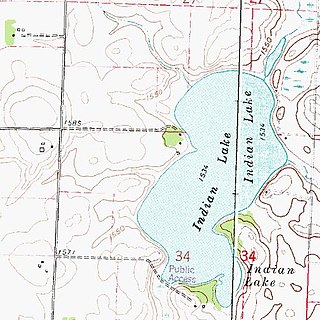
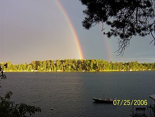
Indian Lake is a small lake located in Indian Lake Township, Nobles County. The lake is an oblong body of water that extends north-to-south for approximately 3/4 mile. The width is approximately 1/2 mile. The lake area is 204 acres (0.83 km2). The average depth is 4.48 feet (1.37 m), and the maximum depth is 6 feet (1.8 m). The elevation of the lake is 1,536 feet (468 m), or 468.17 meters. Nobles county won't take care of it. So it's full of seaweed.

Amelia Lake is a lake in Pope County, Minnesota, the United States, located 6.7 miles away from Glenwood. Amelia lake has an elevation of around 1,348 feet (411 m). The lake sits on a lot of 910 acres. The depth of Amelia Lake is 69 feet (21 m) and water clarity can approach 12 feet (3.7 m) during the summer. This lake is open to the public to fish with a proper fishing license.
Lake Ann is a lake in Carver County, Minnesota, in the United States.

Leggett Bay is located in Waterford Township, Michigan, United States. The 25-acre bay within Lake Oakland (Michigan) lies north of Walton Blvd. near Clintonville Rd. At its deepest point, the bay is 10 feet deep.

Lake Byllesby is a 1,432-acre artificial lake on the Cannon River in Dakota and Goodhue counties, in the U.S. State of Minnesota. The lake was formed as a result of construction of the Byllesby Dam by the H.M. Byllesby & Company, which would later become Northern States Power Company for hydroelectric power generation. Today, the lake serves as a popular recreational destination and is the largest lake in Southern Dakota County, approximately 30 miles (48 km) southeast of the Twin Cities.

Medicine Lake is an inland lake located approximately 8 miles northwest of downtown Minneapolis, Minnesota. The lake lies within Hennepin County and is surrounded by two municipalities. At 902 acres, it is Hennepin County's second largest lake behind Lake Minnetonka and is popular among boaters, sailors, and fishers. Medicine Lake's most significant tributary is Plymouth Creek, which enters the lake at West Medicine Lake Park. The lake is also fed by rain and drainage from nearby cities, including Medicine Lake, Plymouth, New Hope, Golden Valley and Minnetonka.
