Green Point Foreshore and Structures

Last updated

Green Point Foreshore Land and Structures
1306 - Foreshore land and structures - SHR Plan 1888 (5051248b100).jpg
Heritage boundaries
Location9 Pixie Avenue, Green Point, Central Coast, New South Wales, Australia
Coordinates 33°27′47″S151°21′23″E / 33.4631°S 151.3563°E / -33.4631; 151.3563 Coordinates: 33°27′47″S151°21′23″E / 33.4631°S 151.3563°E / -33.4631; 151.3563
OwnerDepartment of Planning and Infrastructure
Official name: Foreshore land and structures; Jetty; boatshed; well and foreshore land associated with Mulholland's Farm
Typestate heritage (built)
Designated9 June 2000
Reference no.1306
TypeOther - Residential Buildings (private)
CategoryResidential buildings (private)
Australia New South Wales relief location map.png
Red pog.svg
Location of Green Point Foreshore Land and Structures in New South Wales

Green Point Foreshore and Structures is a heritage-listed conservation site at 9 Pixie Avenue, Green Point, Central Coast, New South Wales, Australia. It includes the jetty, boatshed, well, and all foreshore land associated with Mulholland's Farm. It was added to the New South Wales State Heritage Register on 9 June 2000. [1]

Green Point, New South Wales Suburb of Central Coast, New South Wales, Australia

Green Point is a south-eastern suburb of the Central Coast region of New South Wales, Australia between Erina and Kincumber along Avoca Drive. It is part of the Central Coast Council local government area.

Central Coast Council (New South Wales) Local government area in New South Wales, Australia

The Central Coast Council is a local government area serving the Central Coast region of New South Wales, Australia, established on 12 May 2016 following the amalgamation of Gosford City and Wyong Shire councils.

New South Wales State of Australia

New South Wales is a state on the east coast of Australia. It borders Queensland to the north, Victoria to the south, and South Australia to the west. Its coast borders the Tasman Sea to the east. The Australian Capital Territory is an enclave within the state. New South Wales' state capital is Sydney, which is also Australia's most populous city. In September 2018, the population of New South Wales was over 8 million, making it Australia's most populous state. Just under two-thirds of the state's population, 5.1 million, live in the Greater Sydney area. Inhabitants of New South Wales are referred to as New South Welshmen.

Contents

History

In October 1881, Carl Ludwig Sahl and John Nobbs purchased a 640-acre land grant in the vicinity of modern-day Green Point, and subdivided it as the Green Point Estate. They retained some of the land, however, including a waterfront section (Lot 1) in the south-west corner of the original grant, and amounted to area of 3 acres 6 roods 1/2 perch. In October 1890, Sahl and Nobbs successfully lobbied the government for rescission of the usual 100' high-water mark reservation between some of their land and Brisbane Water, allowing them to purchase the foreshore land. It was sold to Charles Thomas Sandon in November 1891, to Eliza Sophia Winton in July 1892, and to local farmer Herbert Henry Thompson in 1907. Thompson already owned the adjacent property, and his combined holdings formed what was to become a successful farming operation. He then sold the combined land to George James Mulholland in May 1909. [1]

John Nobbs was an Australian politician.

Brisbane Water bight in Australia

Brisbane Water is a wave-dominated barrier estuary located in the Central Coast region, north of Sydney, New South Wales, Australia. Brisbane Water has its origin at the confluence of the Narara and Coorumbine Creeks, to the south–east of Gosford and travels for approximately 18 kilometres (11 mi) in a southerly direction to its mouth at Broken Bay, about 7 kilometres (4.3 mi) from the Tasman Sea, at Barrenjoey Head. A number of towns surround the shores of Brisbane Water, including Booker Bay, Davistown, Ettalong Beach, Gosford, Green Point, Kincumber, Phegans Bay, Saratoga, Wagstaffe, and Woy Woy. Contained within Brisbane Water is St Huberts Island, Rileys Island, and Pelican Island; and adjoining the estuary is Brisbane Water National Park to the west and Bouddi National Park to the east.

Mulholland subsequently constructed a boat shed, wharf, well, road and water pipeline along the foreshore land, supporting both his farming interests on land and a successful oyster farming venture offshore. [1]

Mulholland's Farm was subdivided in 1961, and in 1975, the high-water reservation of 100' depth was resumed by Gosford City Council and dedicated, together with other areas on Brisbane Water, as a public reserve. This reduced the land area associated with the house to 3154m2, and divorced the wharf and boatshed from the same land title as the house. A sign on the wharf stating "oyster lease" remained on the wharf until the 1980s. [1]

Description

The boatshed is a simple timber framed and weatherboard structure, with a skillion form roof. Located adjacent to the shed are the hardwood planks of the former wharf structure. The concrete piles of the wharf survive. Both of these items appear to be pre-World War II constructions as they appear in the aerial photograph of 1941. [1]

Shed single-storey structure in a back garden or on an allotment that is used for storage

A shed is typically a simple, single-story roofed structure in a back garden or on an allotment that is used for storage, hobbies, or as a workshop. Sheds vary considerably in the complexity of their construction and their size, from small open-sided tin-roofed structures to large wood-framed sheds with shingled roofs, windows, and electrical outlets. Sheds used on farms or in industry can be large structures. The main types of shed construction are metal sheathing over a metal frame, plastic sheathing and frame, all-wood construction, and vinyl-sided sheds built over a wooden frame.

World War II 1939–1945 global war

World War II, also known as the Second World War, was a global war that lasted from 1939 to 1945. The vast majority of the world's countries—including all the great powers—eventually formed two opposing military alliances: the Allies and the Axis. A state of total war emerged, directly involving more than 100 million people from over 30 countries. The major participants threw their entire economic, industrial, and scientific capabilities behind the war effort, blurring the distinction between civilian and military resources. World War II was the deadliest conflict in human history, marked by 50 to 85 million fatalities, most of whom were civilians in the Soviet Union and China. It included massacres, the genocide of the Holocaust, strategic bombing, premeditated death from starvation and disease, and the only use of nuclear weapons in war.

The boat shed has doors to its land and watersides, indicating is use for boats. In it there is a filer pump which is part of an integral irrigation system comprising well (at the foreshore) pipe to the holding tank, and a distribution pump under the house (electric billabong) of pre-World War II vintage. [2] [1]

Heritage listing

The jetty, boatshed, well and foreshore land was owned and managed as an integral part of Mulholland's Farm between 1891 and 1975. The boatshed and remnants of the hardwood framed jetty are a tangible association between the house and the use of brisbane Water as a means of either transport, and/or an economic activity such as oyster farming. Furthermore, its significance as the most intact surviving farm on the Brisbane Water (from the farm subdivision era of the 1880s to 1945) derives from the fact that it retains the physical and visual evidence of Mulholland's Farm's association with the waterway. [2] [1]

Green Point Foreshore and Structures was listed on the New South Wales State Heritage Register on 9 June 2000. [1]

See also

Related Research Articles

Parramatta River River in Australia

The Parramatta River is an intermediate tide dominated, drowned valley estuary located in Sydney, New South Wales, Australia. With an average depth of 5.1 metres (17 ft), the Parramatta River is the main tributary of Sydney Harbour, a branch of Port Jackson. Secondary tributaries include the smaller Lane Cove and Duck rivers.

Tuggerah Lake estuary in New South Wales, Australia

Tuggerah Lake, an intermittently open intermediate wave dominated barrier estuary that is part of the Tuggerah Lakes, is located within the Central Coast Council local government area in the Central Coast region of New South Wales, Australia. The lake is located near Wyong and is situated about 90 kilometres (56 mi) north of Sydney.

Milsons Point, New South Wales Suburb of Sydney, New South Wales, Australia

Milsons Point is a suburb on the lower North Shore of Sydney, in the state of New South Wales, Australia. The suburb is located 3 kilometres north of the Sydney central business district in the local government area of North Sydney Council.

Holman Street ferry wharf

Holman Street ferry wharf is located on the southern side of the Brisbane River in Kangaroo Point, City of Brisbane, Queensland, Australia. It is served by Transdev Brisbane Ferries' CityHopper and the cross-river service to Eagle Street Pier.

Ettalong Beach, New South Wales Suburb of Central Coast, New South Wales, Australia

Ettalong Beach is a suburb of the Central Coast region of New South Wales, Australia south of Woy Woy on Brisbane Water at the point where it meets Broken Bay, about 80 km north of Sydney. It is part of the Central Coast Council local government area. Ettalong Beach is the natural eastward continuation of Umina Beach and Ocean Beach. The village is serviced by a small retail centre along Ocean View Road.

Mooney Mooney, New South Wales Suburb of Central Coast, New South Wales, Australia

Mooney Mooney is a suburb of the Central Coast region of New South Wales, Australia, located at the end of a peninsula extending southwards into the Hawkesbury River estuary. 48 kilometres (30 mi) north of Sydney. Mooney Mooney is the location at which the Sydney-Newcastle Freeway and Pacific Highway cross from the Central Coast into Sydney's metropolitan area at Brooklyn in the Hornsby Shire.

Patonga is a suburb of the Central Coast region of New South Wales, Australia, located on the north bank of the Hawkesbury River, southwest of Woy Woy. It is part of the Central Coast Council local government area.

Point Clare is a suburb of the Central Coast region of New South Wales, Australia located 4 kilometres (2 mi) south-west of Gosford's central business district on the western shore of Brisbane Water. It is part of the Central Coast Council local government area.

Finger Wharf wharf in Woolloomooloo Bay, Sydney, Australia

The Finger Wharf is a heritage-listed former wharf and passenger terminal and now marina, residential apartments, hotel and restaurant located at 6 Cowper Wharf Road, in the inner city Sydney suburb of Woolloomooloo in the City of Sydney local government area of New South Wales, Australia. It was designed by Henry D. Walsh and built from 1910 to 1916 by the Sydney Harbour Trust. It is also known as Woolloomooloo Finger Wharf and Woolloomooloo Wharf. The property is owned by NSW Maritime, an agency of the Government of New South Wales. It was added to the New South Wales State Heritage Register on 18 April 2000. The structure is the longest timbered-piled wharf in the world.

Petrie Bight bight in Australia

Petrie Bight is a reach of the Brisbane River in Brisbane, Queensland, Australia. The small pocket of land to the north of the bight, centred on the area under the Story Bridge's northern point and around the Brisbane River to Customs House is also known as Petrie Bight; it falls within the suburbs of the Brisbane CBD and Fortitude Valley. However, land to the south of the reach Petrie Bight does not use that name, and is known by its suburb name of Kangaroo Point.

Southport Pier, Gold Coast

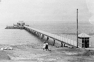
Southport Pier is a pier spanning the Gold Coast Broadwater in Southport, a suburb on the Gold Coast in South East Queensland, Australia. The current pier was constructed in 2009, replacing a previous structure demolished in 1969.

Port Kembla (seaport) man-made cargo port in the Illawarra region of New South Wales, Australia

Port Kembla is a man-made cargo port or artificial harbour, with an outer harbour protected by breakwaters and an inner harbour constructed by dredging, located in the Illawarra region of New South Wales, Australia.

Port Douglas Wharf

Port Douglas Wharf is a heritage-listed wharf at 6 Dixie Street, Port Douglas, Shire of Douglas, Queensland, Australia. It was built in 1904. It was also known as Shipwreck Museum. It was added to the Queensland Heritage Register on 21 October 1992.

Tathra Wharf

Tathra Wharf is a heritage-listed former wharf precinct and now museum and cafe at Wharf Road, Tathra, Bega Valley Shire, New South Wales, Australia. It was built from 1860 to 1862. The property is owned by the Department of Planning and Infrastructure. It was added to the New South Wales State Heritage Register on 2 April 1999.

Fernleigh, Caringbah South homestead in Caringbah South, New South Wales, Australia

Fernleigh is a heritage-listed former boatshed and homestead and now residence located at 44-46 Fernleigh Road, Caringbah South in the Sutherland Shire local government area of New South Wales, Australia. It is also known as Mandalay and York House. The property is privately owned. It was added to the New South Wales State Heritage Register on 2 April 1999.

Mulhollands Farm

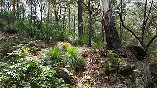
Mulholland's Farm is a heritage-listed residence at 9 Pixie Avenue, Green Point, Central Coast, New South Wales, Australia. It was built in 1907. It was added to the New South Wales State Heritage Register on 2 April 1999.

Walsh Bay Wharves Precinct

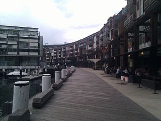
The Walsh Bay Wharves Precinct is a heritage-listed former wharf precinct, now converted to hospitality and entertainment purposes, at Hickson Road, in the inner city Sydney suburb of Millers Point in the City of Sydney local government area of New South Wales, Australia. It was designed by H. D. Walsh, who also supervised its construction from 1912 to 1921. It includes the MSB Bond Store No. 3 and the Parbury Ruins. It was added to the New South Wales State Heritage Register on 2 April 1999.

Man OWar Steps

The Man O'War Steps is a heritage-listed jetty located at Farm Cove Crescent, in the Sydney central business district, in the City of Sydney local government area of New South Wales, Australia. It was built from 1810. The property is owned by NSW Maritime, an agency of the Government of New South Wales. It was added to the New South Wales State Heritage Register on 18 April 2000. The Steps are located on the eastern bank of Bennelong Point, adjacent to the Sydney Opera House and on the north-western boundary of the Royal Botanic Garden.

References

  1. 1 2 3 4 5 6 7 8 "Foreshore land and structures". New South Wales State Heritage Register . Office of Environment and Heritage. H01306. Retrieved 2 June 2018.
  2. 1 2 Clive Lucas Stapleton, 1999

Bibliography

Attribution

CC-BY-icon-80x15.png This Wikipedia article was originally based on Foreshore land and structures , entry number 01306 in the New South Wales State Heritage Register published by the State of New South Wales and Office of Environment and Heritage 2018 under CC-BY 4.0 licence , accessed on 2 June 2018.