Related Research Articles
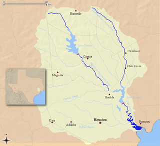
The San Jacinto River flows through southeast Texas. It is named after Saint Hyacinth. In the past, it was home to the Karankawa and Akokisa tribes.
The Memorial area of Houston, Texas is located west of Downtown, northwest of Uptown, and south of Spring Branch. The Memorial Super Neighborhood, as defined by the City of Houston, is bounded by Buffalo Bayou to the south, Barker Reservoir to the west, Westview to the north, and the Memorial Villages, a contiguous group of independent municipalities, to the east.
The Aldine Independent School District is a public school district based in unincorporated Harris County, Texas, United States. It serves portions of Houston and unincorporated Harris County. Aldine ISD serves the communities of Aldine, most of Greenspoint, most of East Aldine, and portions of Airline, Acres Homes, Kinwood, Bordersville, and Inwood Forest. The district is part of the taxation base for the Lone Star College System. As of 2020, Dr. LaTonya Goffney serves as superintendent of schools.

Acres Homes is a neighborhood located in northwest Houston, Texas. The 9-square-mile (23 km2) mile area is loosely bounded by the city limits and West Gulf Bank Road to the north; Pinemont Drive to the south; North Shepherd Drive to the east; and Alabonson Drive to the west. Historically, it has been predominantly African American. Unincorporated for decades, it was annexed to Houston in 1967.

Rice Military is a neighborhood in Houston, Texas, United States. The Beer Can House is located in Rice Military.

Inwood Forest is a community about a 3/4 mile west of historic Acres Homes in northwest Houston, Texas, United States.

Sheldon Independent School District is a public school district in unincorporated northeast Harris County, Texas (USA). The majority of the district lies in the extraterritorial jurisdiction of Houston with a small portion within city limits.

Greater Greenspoint, also referred to as the North Houston District, is a 7-square-mile (18 km2) business district and a suburban neighborhood in northern Harris County, Texas, United States, located mostly within the city limits of Houston. Centered around the junction of Interstate 45 and Texas State Highway Beltway 8 near George Bush Intercontinental Airport, the area is a classic example of a planned edge city. The initial 2,000-acre (8.1 km2) retail and office development centered around Greenspoint Mall was a project of the Friendswood Development Company during the 1970s and early 1980s.
North Shore is a community in east side of Harris County, Texas with a small portion inside the city of Houston, Texas. The area includes subdivisions such as Songwood, Holiday Forest, Wood Bayou, Cimarron, Home Owned Estates, Woodland Acres, Hidden Forest, Pine Trails, Woodforest, Woodforest North, New Forest, and New Forest West, as well as newer neighborhoods near Highway 90 and Beltway 8 North Sam Houston Parkway.
Cloverland is a neighborhood located on the south side of Houston, Texas, United States.

The Energy Corridor is a business district in Houston, Texas, located on the west side of the metropolitan area between Beltway 8 and the Grand Parkway. The district straddles a 7-mile (11 km) stretch of Interstate 10 from Kirkwood Road westward to Barker Cypress Road and extends south along Eldridge Parkway to Briar Forest Drive. Parts of the district overlap with the Memorial area of Houston. The district is located north of Westchase, another major business district of Houston, and east of Greater Katy.
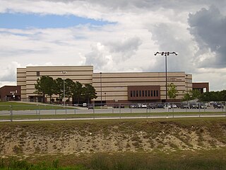
The M.O. Campbell Educational Center is an indoor arena in Houston, Texas. The facility serves as the home basketball and volleyball court for the five high schools in the Aldine Independent School District (AISD). The Campbell Center is also used for graduations, theatrical performances, meetings, conferences, banquets and community events.

Bordersville is a predominantly African American community on Farm to Market Road 1960 in northeast Harris County, Texas, United States. The community, located less than one half-mile from George Bush Intercontinental Airport, has about 80% of its territory in the City of Houston and the rest in an unincorporated area.
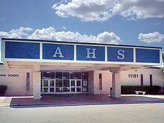
Aldine Senior High School is a public high school located in the Greenspoint district of northern Houston, Texas, United States. It is part of the Aldine Independent School District. The senior high school campus serves grades 10 through 12. The separate Aldine Ninth Grade School hosts students in grade 9.

East Aldine is a state management district in Harris County, Texas, United States, mostly in unincorporated areas, with some territory in the City of Houston. The East Aldine Improvement District, also known as the Aldine Management District, governs the area. Portions of the district coincide with the boundaries of the Aldine census-designated place. One park owned by the City of Houston, Keith-Wiess Park, is within the district limits.
The Airline Improvement District is a management district in unincorporated Harris County, Texas, United States, in Greater Houston and is located entirely within the postal zip code of 77037.
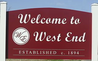
West End is a neighborhood in Houston, Texas, United States located along the Washington Avenue Corridor.
Near Northwest is a 16-square-mile (41 km2) district located in Harris County, Texas, partly within the city limits of Houston and partly in an unincorporated area. It is governed by the Near Northwest Management District, with its headquarters at the White Oak Conference Center, 7603 Antoine Dr, Houston, Texas.

W.W. Thorne Stadium, an American football and soccer venue, is the home stadium of the Aldine Independent School District's five varsity high school football teams - the Aldine Mustangs, Davis Falcons, Eisenhower Eagles, MacArthur Generals and Nimitz Cougars of District 18-6A, as well as for each schools' varsity boys and girls soccer teams.
Halls Bayou is a bayou in the northern part of Houston, Texas. It begins just north of W Mt Houston Road and flows for 17 miles (27 km). It empties into Greens Bayou in Brock Park and Golf Course. Originally known as the “south fork of Greens Bayou,” it was renamed in the 1880s, apparently for Archibald S. Hall, who owned land along the bayou.
References
- ↑ Archived 2017-12-22 at the Wayback Machine , Aldine ISD School Boundary Maps.
29°56′53″N95°28′33″W / 29.94806°N 95.47583°W
 | This article about a location in Harris County, Texas is a stub. You can help Wikipedia by expanding it. |
| | This Houston-related article is a stub. You can help Wikipedia by expanding it. |