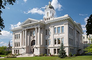
Missoula County is located in the State of Montana. As of the 2020 census, the population was 117,922, making it Montana's third-most populous county. Its county seat and largest city is Missoula. The county was founded in 1860.

The Yellowstone River is a tributary of the Missouri River, approximately 692 miles (1,114 km) long, in the Western United States. Considered the principal tributary of upper Missouri, via its own tributaries it drains an area with headwaters across the mountains and high plains of southern Montana and northern Wyoming, and stretching east from the Rocky Mountains in the vicinity of Yellowstone National Park. It flows northeast to its confluence with the Missouri River on the North Dakota side of the border, about 25 miles west of present-day Williston.

The Madison River is a headwater tributary of the Missouri River, approximately 183 miles (295 km) long, in Wyoming and Montana. Its confluence with the Jefferson and Gallatin rivers near Three Forks, Montana forms the Missouri River.
The Big Hole River is a tributary of the Jefferson River, approximately 153 miles (246 km) long, in Beaverhead County, in southwestern Montana, United States. It is the last habitat in the contiguous United States for native fluvial Arctic grayling and is a historically popular destination for fly fishing, especially for trout.
Spring Meadow Lake State Park is a public recreation area covering 61 acres (25 ha) just west of Helena, Montana. Once the site of a gravel pit and factory, the state park centers around a man-made, spring-fed lake, which is used for swimming, fishing, non-motorized boating, and scuba diving. The park also offers picnicking, a mile-long trail around the lake, and ice fishing and ice skating in winter. Largemouth bass, westslope cutthroat trout, yellow perch, and pumpkinseed are the main catches. A fishing pier was added to 30-acre (12 ha) lake in 2011.
Lake Sherburne is located in the Many Glacier region of Glacier National Park, in the U.S. state of Montana. The lake is a reservoir, formed by Lake Sherburne Dam, which held back Swiftcurrent Creek and was constructed between 1914 and 1921. The construction of the dam filled up several small lakes and highly productive river transition and wetland areas, and due to its fluctuating water levels, the surrounding area supports little vegetation. However, trumpeter swans are often observed along the lake in the spring and fall. The lake stretches nearly 6 mi (9.7 km) when full. The reservoir is the principal water storage component of the U.S. Bureau of Reclamation's Milk River Project, which provides irrigation water to north central Montana farms.

Lake Elmo State Park is a public recreation area located on the northeast side of Billings, Montana. The state park occupies 123 acres (50 ha) and is at an elevation of 3,199 feet (975 m). It offers non-motorized boating on a 64-acre (26 ha) reservoir, three beach-front areas, fishing pier, grassed multi-use areas, two group-use shelters, playground, and fenced-in dog park on the lake's west side.

Whitefish Lake State Park is a 10-acre (4.0 ha) public recreation area on Whitefish Lake off of U.S. Highway 93, two miles northwest of Whitefish, Montana. It offers boating, swimming, tent and RV camping, and fishing. Sites for hike-in and bike-in camping were added in 2016.
The culture of Missoula, Montana is influenced by the nearby University of Montana in art, sports, and music with the city's location in a mountain river valley also encouraging outdoor events and recreation.
Ackley Lake State Park is a public recreation area located four miles southwest of Hobson, Montana. The state park covers 290 acres (120 ha) centered around 160-acre (65 ha) Ackley Lake. The Little Belt Mountains and Snowy Mountains are visible on the horizon. The park is operated by the Montana Department of Fish, Wildlife and Parks on land leased from the Montana Department of Natural Resources and Conservation.
Big Arm State Park is a Montana state park that is a unit of Flathead Lake State Park near Big Arm, Montana. Big Arm State Park is located on the western shores of Flathead Lake, the largest natural freshwater lake in the western United States. The park's recreational activities include fishing, boating, RV and tent camping, and swimming.

Placid Lake State Park is a public recreation area located 28 miles (45 km) northeast of Missoula, Montana. The state park sits on 31 acres (13 ha) at the eastern end of Placid Lake that include the lake's outlet to Owl Creek, a tributary of the Clearwater River. The park is known for its scenery, camping, aquatic recreation, and fishing.

West Shore State Park is a public recreation area occupying 129 acres on the western shore of Flathead Lake five miles south of Lakeside in Lake County, Montana. The state park offers boating, fishing, camping, swimming, hiking, and wildlife viewing.

Lake Mary Ronan State Park is a public recreation area located seven miles (11 km) northwest of the Flathead Lake community of Dayton, Montana. The state park occupies 120 acres (49 ha) on the east side of 1,500-acre (610 ha) Lake Mary Ronan. The lake is 47 feet deep at its deepest spot and is known for kokanee salmon and yellow perch. Twenty-five campsites and a boat ramp are found in the park.
Logan State Park is a public recreation area on the north shore of Middle Thompson Lake, off US Route 2 midway between Libby and Kalispell, Montana. The state park encompasses 17 acres (6.9 ha) within 3,000-acre Thompson Chain of Lakes State Park. It offers swimming, boating, fishing, and camping.
Oaks Creek is a river that drains Canadarago Lake, which is situated in the north central region of Otsego County, New York. The creek begins by the Hamlet of Schuyler Lake and flows southeast approximately 9.32 miles (15.00 km), dropping only 105 feet (32 m) in elevation, before converging with the Susquehanna River south of the Village of Cooperstown, by the Hamlet of Index. From the source to Oaksville the creek flows along Panther Mountain. Fly Creek is a main tributary, that converges with Oaks Creek south of the Hamlet of Fly Creek.

Yellow Bay State Park is a public recreation area occupying fifteen acres (6.1 ha) on the eastern shore of Flathead Lake twelve miles (19 km) south of Bigfork in Lake County, Montana. The state park offers boating, fishing, camping, swimming, and wildlife viewing.
Tally Lake is a freshwater lake located in Flathead County, Montana in the northwestern region of the United States. The lake is about 20 miles (32 km) west of the town of Whitefish. It is a popular lake for recreational activities including fishing, boating, swimming and cliff jumping, and hiking on the surrounding trails, and is notable for its great depth and unusual geology. The lake's surface area is over 1,200 acres (490 ha). The lake is located at 3,356 feet (1,023 m) above sea level. It is about 445 feet (136 m) deep at its deepest point, making it the deepest lake in Montana and the deepest natural lake. Despite its large volume, the lake tends to be warm in late summer because its waters are darkly colored due to high levels of tannins. These cause the lake to absorb and retain more heat than comparatively clearer bodies of water in the region.
Alice Greenough Orr, was an internationally known rodeo performer and rodeo organizer who was inducted into the Rodeo Hall of Fame, the National Cowgirl Museum and Hall of Fame, and the Montana Cowboy Hall of Fame. She has been described as "hands down the first rodeo queen."
