This article duplicates the scope of other articles, specifically Greenville-Kinston-Washington CSA.(August 2023) |
This article duplicates the scope of other articles, specifically Greenville-Kinston-Washington CSA.(August 2023) |
The Greenville, North Carolina Combined Statistical Area is newly established and is defined by the United States Census Bureau as the Greenville, NC Metropolitan Statistical Area and the Washington, NC Micropolitan Statistical Area. The 2012 population estimate was 220,061.

Greenville County is located in the U.S. state of South Carolina. As of the 2020 census, the population was 525,534, making it the most populous county in the state. Its county seat is Greenville. The county is also home to the Greenville County School District, the largest school system in South Carolina.
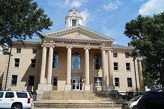
Pitt County is a county located in the Inner Banks region of the U.S. state of North Carolina. As of the 2020 census, the population was 170,243, making it the 14th-most populous county in North Carolina. Its county seat is Greenville.

Beaufort County is a county located in the U.S. state of North Carolina. As of the 2020 census, the population was 44,652. Its county seat is Washington. The county was founded in 1705 as Pamptecough Precinct. Originally included in Bath County, it was renamed Beaufort Precinct in 1712 and became Beaufort County in 1739.

Washington County is a county located in the U.S. state of Mississippi. As of the 2020 census, the population was 44,922. Its county seat is Greenville. The county is named in honor of the first president of the United States, George Washington. It is located next to the Arkansas border.

Greenville is a city and the county seat of Meriwether County, Georgia, United States. The population was 794 at the 2020 census, down from 876 in 2010. The city is located 60 miles (97 km) southwest of Atlanta and is part of the Atlanta metropolitan area.

Gastonia is the most populous city in and the county seat of Gaston County, North Carolina, United States. It is the second-largest satellite city of the Charlotte area, behind Concord. The population was 80,411 in the 2020 census, up from 71,741 in 2010. Gastonia is the 13th-most populous city in North Carolina. It is part of the Charlotte-Concord-Gastonia, NC-SC Metropolitan Statistical Area, which is part of the Charlotte-Concord, NC-SC Combined Statistical Area.

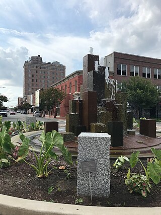
Greenville is the county seat and most populous city of Pitt County, North Carolina, United States. It is the principal city of the Greenville, NC Metropolitan Statistical Area, and the 12th-most populous city in North Carolina. Greenville is the health, entertainment, and educational hub of North Carolina's Tidewater and Coastal Plain. As of the 2020 census, there were 87,521 people in the city. The city has continued to see a population and economic boom with most of the growth being seen in the 20th and 21st centuries.
Goldsboro, originally Goldsborough, is a city in and the county seat of Wayne County, North Carolina, United States. The population was 33,657 at the 2020 census. It is the principal city of and is included in the Goldsboro, North Carolina Metropolitan Statistical Area. The nearby town of Waynesboro was founded in 1787, and Goldsboro was incorporated in 1847. It is the county seat of Wayne County.

Greenville is a city in and the county seat of Greenville County, South Carolina, United States. With a population of 70,720 at the 2020 census, it is the sixth-most populous city in the state. The Greenville metropolitan area had 928,195 residents in 2020 and is the second-largest metro area in South Carolina. Greenville is the anchor city of Upstate South Carolina, an economic and cultural region with an estimated population of 1.59 million as of 2023.

Mauldin is a city in Greenville County, South Carolina, United States. The population was 24,724 at the 2020 census, making it the 19th-most populous city in South Carolina. It is located in the Greenville-Anderson-Greer, SC Metropolitan Statistical Area.
Travelers Rest is a city in Greenville County, South Carolina. The population was 7,788 at the 2020 census. It is part of the Greenville-Mauldin-Easley Metropolitan Statistical Area. Travelers Rest, the northernmost city in Greenville County, is located 10 miles north of Greenville and around 20 miles south of the North Carolina border. Furman University, a private liberal-arts university, was annexed into the city limits of Travelers Rest in April 2018 and North Greenville University, a private Christian institution, is located in nearby Tigerville.

Greer is a city in the Greenville and Spartanburg counties in the U.S. state of South Carolina. As of the 2020 census, the population was 35,308, making it the 14th-most populous city in South Carolina. Greer is included in the Greenville-Anderson-Greer, SC Metropolitan Statistical Area, which is part of the Greenville-Spartanburg-Anderson, SC Combined Statistical Area in Upstate South Carolina.

U.S. Route 264 (US 264) is an east–west United States Highway located completely within the U.S. state of North Carolina, running for 215.7 miles (347.1 km). Its western terminus is located at Interstate 87 (I-87), I-440, and US 64 in Raleigh. US 264 is a freeway between Raleigh and Wilson, with segments running concurrently with I-87, I-587, I-795, and US 64. The highway is largely parallel to I-587 between Wilson and Greenville and primarily serves smaller communities such as Saratoga and Farmville. East of Greenville, US 264 is an important highway connecting communities such as Washington, Belhaven, Swan Quarter, and Engelhard. The eastern terminus of US 264 is located at US 64 in Manns Harbor.

The Louisville metropolitan area is the 43rd largest metropolitan statistical area (MSA) in the United States. It had a population of 1,395,855 in 2020 according to the latest official census, and its principal city is Louisville, Kentucky.

The Upstate, historically known as the Upcountry, is a region of the U.S. state of South Carolina, comprising the northwesternmost area of the state. Although loosely defined among locals, the general definition includes the 10 counties of the commerce-rich I-85 corridor in the northwest corner of South Carolina. This definition coincided with the Greenville-Spartanburg-Anderson, SC Combined Statistical Area, as first defined by the Office of Management and Budget (OMB) in 2015. In 2023, the OMB issued its most updated definition of the CSA that coincides again with the 10-county region.

North Carolina Highway 11 is a primary state highway in the U.S. state of North Carolina. Traveling 193.2 miles (310.9 km) in a north–south alignment through Eastern North Carolina, it connects the towns and cities of Wallace, Kenansville, Kinston, Greenville and Murfreesboro.

The United States Commonwealth of Virginia currently has 20 statistical areas that have been delineated by the Office of Management and Budget (OMB). On July 21, 2023, the OMB delineated four combined statistical areas, 12 metropolitan statistical areas, and four micropolitan statistical areas in Virginia.

North Carolina Highway 33 (NC 33) is a primary state highway in the U.S. state of North Carolina. Spanning a distance of 110 miles (180 km), the east–west route passes through many small towns and communities in Eastern North Carolina's Inner Banks. It bypasses a large portion of the cities of Rocky Mount and Greenville, and goes through central Tarboro.

Greater Dayton or the Miami Valley, or more formally the Dayton–Kettering–Beavercreek, OH Metropolitan Statistical Area, as defined by the United States Census Bureau, is an area consisting of three counties in the Miami Valley region of Ohio and is anchored by the city of Dayton. As of 2020, it is the fourth-largest metropolitan area in Ohio and the 73rd-largest metropolitan area by population in the United States with a population of 814,049.
The Greenville-Kinston-Washington, NC Combined Statistical Area, as defined by the United States Census Bureau, is an area consisting of three counties in Eastern North Carolina. As of the 2011 census estimate, the CSA had a population of 427,723, compared to 399,848 in the 2009 census estimate. It includes the Greenville, NC CSA