
Glaciology is the scientific study of glaciers, or more generally ice and natural phenomena that involve ice.

The Aletsch Glacier or Great Aletsch Glacier is the largest glacier in the Alps. It has a length of about 23 km (14 mi) (2014), has about a volume of 15.4 km3 (3.7 cu mi) (2011), and covers about 81.7 km2 (2011) in the eastern Bernese Alps in the Swiss canton of Valais. The Aletsch Glacier is composed of four smaller glaciers converging at Concordia Place, where its thickness was measured by the ETH to be still near 1 km (3,300 ft). It then continues towards the Rhône valley before giving birth to the Massa. The Aletsch Glacier is – like most glaciers on this world – a retreating glacier. As of 2016, since 1980 it lost 1.3 kilometres (0.81 mi) of its length, since 1870 3.2 kilometres (2.0 mi), and lost also more than 300 metres (980 ft) of its thickness.
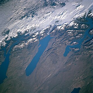
In geology, a proglacial lake is a lake formed either by the damming action of a moraine during the retreat of a melting glacier, a glacial ice dam, or by meltwater trapped against an ice sheet due to isostatic depression of the crust around the ice. At the end of the last ice age approximately 10,000 years ago, large proglacial lakes were a widespread feature in the northern hemisphere.

The Swiss Plateau or Central Plateau is one of the three major landscapes in Switzerland, lying between the Jura Mountains and the Swiss Alps. It covers about 30% of the Swiss surface area, and is partly flat but mostly hilly. The average height is between 400 metres (0.25 mi) and 700 metres (0.43 mi) AMSL. It is by far the most densely populated region of Switzerland, the center of economy and important transportation.
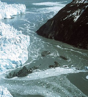
A glacial lake outburst flood (GLOF) is a type of outburst flood that occurs when the dam containing a glacial lake fails. An event similar to a GLOF, where a body of water contained by a glacier melts or overflows the glacier, is called a Jökulhlaup. The dam can consist of glacier ice or a terminal moraine. Failure can happen due to erosion, a buildup of water pressure, an avalanche of rock or heavy snow, an earthquake or cryoseism, volcanic eruptions under the ice, or if a large enough portion of a glacier breaks off and massively displaces the waters in a glacial lake at its base.

The retreat of glaciers since 1850 affects the availability of fresh water for irrigation and domestic use, mountain recreation, animals and plants that depend on glacier-melt, and, in the longer term, the level of the oceans. Studied by glaciologists, the temporal coincidence of glacier retreat with the measured increase of atmospheric greenhouse gases is often cited as an evidentiary underpinning of global warming. Mid-latitude mountain ranges such as the Himalayas, Alps, Rocky Mountains, Cascade Range, and the southern Andes, as well as isolated tropical summits such as Mount Kilimanjaro in Africa, are showing some of the largest proportionate glacial losses.
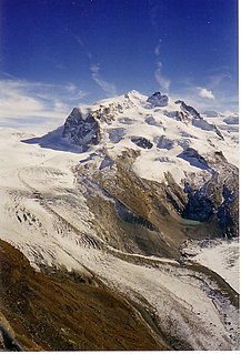
The Gorner Glacier is a valley glacier found on the west side of the Monte Rosa massif close to Zermatt in the canton of Valais, Switzerland. It is about 12.4 km (7.7 mi) long (2014) and 1 to 1.5 km wide. The entire glacial area of the glacier related to Gorner Glacier is 57 km2 (22 sq mi) (1999), which makes it the second largest glacial system in the Alps after the Aletsch Glacier system; however it ranks only third in length behind the Aletsch and Fiescher Glacier, respectively. Numerous smaller glaciers connect with the Gorner Glacier. Its (former) tributaries are : Gornergletscher, Monte Rosa Gletscher, Grenzgletscher, Zwillingsgletscher, Schwärzegletscher, Breithorngletscher, Triftjigletscher, and Unterer Theodulgletscher.

The Findel Glacier is a valley glacier in the Monte Rosa massif east of Zermatt in the Pennine Alps. It has a length of 8 km (5.0 mi) and covers an area of 19 km2 (7.3 sq mi).

Baudissin Glacier is a tidewater glacier on the north side of Heard Island. in the southern Indian Ocean. Located 1 nautical mile (1.9 km) west of Challenger Glacier, Baudissin Glacier is 1.5 nautical miles (2.8 km) wide and flows into the western part of Corinthian Bay. The terminus of Baudissin Glacier is located at the western side of Corinthian Bay, at Sealers Cove. To the east of Baudissin Glacier is Challenger Glacier, whose terminus is located at the eastern side of Corinthian Bay, close west to Saddle Point. To the south of Baudissin Glacier is Schmidt Glacier, and to the northwest is Atlas Cove. Kildalkey Head is west of Schmidt Glacier. To the south of Schmidt Glacier is Vahsel Glacier, whose terminus is at South West Bay, between Erratic Point and Cape Gazert. Immediately south of Vahsel Glacier is Allison Glacier. Click here to see a map of Baudissin Glacier and the northwestern coast of Heard Island.
Challenger Glacier is a tidewater glacier on the north side of Heard Island in the southern Indian Ocean. Located 1 nautical mile (2 km) east of Baudissin Glacier, Challenger Glacier is 0.8 nautical miles (1.5 km) wide and flows into the eastern side of Corinthian Bay, close west to Saddle Point. To the east of Challenger Glacier is Downes Glacier, whose terminus is located at Mechanics Bay, between Saddle Point and Cape Bidlingmaier. To the west of Challenger Glacier is Baudissin Glacier, whose terminus is located at the western side of Corinthian Bay, near Sealers Cove.
Compton Glacier is a glacier, 3 nautical miles (6 km) long, flowing northeast from the lower slopes of the Big Ben massif to the northeast side of Heard Island in the southern Indian Ocean. Its terminus is located at Compton Lagoon, between Gilchrist Beach and Fairchild Beach. To the northwest of Compton Glacier is Ealey Glacier, whose terminus is located close southeast of Cape Bidlingmaier. To the southeast of Compton Glacier is Brown Glacier, whose terminus is located at Brown Lagoon. Round Hill separates Compton Glacier from Brown Glacier.

Gotley Glacier is a well-defined glacier, 5 nautical miles (9 km) long, descending from the ice-covered slopes of the Big Ben massif to the southwest side of Heard Island in the southern Indian Ocean. Its terminus is located between Cape Arkona and Cape Labuan. To the east of Gotley Glacier is Deacock Glacier, whose terminus is located between Cape Labuan and Long Beach. To the northwest of Gotley Glacier is Lied Glacier, whose terminus is located between Cape Arkona and Cape Pillar. Cape Arkona separates Gotley Glacier from Lied Glacier.
Stephenson Glacier is a glacier close west of Dovers Moraine on the east side of Heard Island in the southern Indian Ocean. Its terminus is between Dovers Moraine and Stephenson Lagoon, with part of the glacier flowing to Doppler Hill and Sealers Beach. To the north of Stephenson Glacier is Brown Glacier, whose terminus is located at Brown Lagoon. To the southwest of Stephenson Glacier is Winston Glacier, whose terminus is located at Winston Lagoon, between Cape Lockyer and Oatt Rocks.
Deacock Glacier is a glacier close west of Lavett Bluff on the south side of Heard Island in the southern Indian Ocean. Its terminus is between Cape Labuan and Long Beach. To the east of Deacock Glacier is Fiftyone Glacier, whose terminus is located between Lavett Bluff and Lambeth Bluff. To the west of Deacock Glacier is Gotley Glacier, whose terminus is located between Cape Arkona and Cape Labuan.
Winston Glacier is a glacier flowing to Winston Lagoon on the southeast side of Heard Island in the southern Indian Ocean. Its terminus is at Winston Lagoon, between Cape Lockyer and Oatt Rocks. To the northeast of Winston Glacier is Stephenson Glacier, whose terminus is located between Dovers Moraine and Stephenson Lagoon. To the southwest of Winston Glacier is Fiftyone Glacier, whose terminus is located between Lavett Bluff and Lambeth Bluff.
Fiftyone Glacier is a large glacier flowing southwards, on the south side of Heard Island in the southern Indian Ocean. Its terminus is located between Lavett Bluff and Lambeth Bluff. To the northeast of Fiftyone Glacier is Winston Glacier, whose terminus is located at Winston Lagoon, between Cape Lockyer and Oatt Rocks. To the west of Fiftyone Glacier is Deacock Glacier, whose terminus is located between Cape Labuan and Long Beach.
Vahsel Glacier is a glacier on the northwestern side of Heard Island in the southern Indian Ocean. It flows west into South West Bay, between Erratic Point and Cape Gazert. Immediately to the north of Vahsel Glacier is Schmidt Glacier, whose terminus is located between Mount Drygalski and North West Cornice. To the south of Vahsel Glacier is Allison Glacier, whose terminus is located south of Cape Gazert, which separates Allison Glacier from Vahsel Glacier. Click here to see a map of Vahsel Glacier and the northwestern coast of Heard Island.
Ealey Glacier is a glacier, flowing northeast from the lower slopes of the Big Ben massif to the northeast side of Heard Island in the southern Indian Ocean. Its terminus is located close southeast of Cape Bidlingmaier, between Melbourne Bluff and North Barrier. The glacier terminates in ice cliffs. To the southeast of Ealey Glacier is Compton Glacier, whose terminus is located at Compton Lagoon, between Gilchrist Beach and Fairchild Beach. To the west of Ealey Glacier is Downes Glacier, whose terminus is located at Mechanics Bay, between Saddle Point and Cape Bidlingmaier.
Allison Glacier is an ice stream on the west side of Heard Island in the southern Indian Ocean. Allison Glacier flows from Big Ben massif down to the sea to the south of Cape Gazert.
To the north of Allison Glacier is Vahsel Glacier, whose terminus is at South West Bay, between Erratic Point and Cape Gazert. Immediately to the north of Vahsel Glacier is Schmidt Glacier, whose terminus is located between Mount Drygalski and North West Cornice. To the south of Allison Glacier is Abbotsmith Glacier, while Cape Gazert is immediately west.


