
The Lepontine Alps are a mountain range in the north-western part of the Alps. They are located in Switzerland and Italy.

The Bernese Alps are a mountain range of the Alps, located in western Switzerland. Although the name suggests that they are located in the Berner Oberland region of the canton of Bern, portions of the Bernese Alps are in the adjacent cantons of Valais, Fribourg and Vaud, the latter being usually named Fribourg Alps and Vaud Alps respectively. The highest mountain in the range, the Finsteraarhorn, is also the highest point in the canton of Bern.
This article lists the principal mountain passes and tunnels in the Alps, and gives a history of transport across the Alps.

The Simplon Pass is a high mountain pass between the Pennine Alps and the Lepontine Alps in Switzerland. It connects Brig in the canton of Valais with Domodossola in Piedmont (Italy). The pass itself and the villages on each side of it, such as Gondo, are in Switzerland. The Simplon Tunnel was built beneath the vicinity of the pass in the early 20th century to carry rail traffic between the two countries.
The Oberhalbstein Alps or Platta Group are a mountain range in the Alps of eastern Switzerland and northern Italy. They are considered to be part of the Central Eastern Alps. The Oberhalbstein Alps are separated from the Lepontine Alps in the west by the Splügen Pass; from the Plessur Alps in the north by the river Albula; from the Albula Alps in the east by the Septimer Pass and the river Gelgia; from the Bernina Range in the south by the Val Bregaglia.

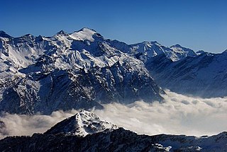
The Alps cover a large area. This article describes the delimitation of the Alps as a whole and of subdivisions of the range, follows the course of the main chain of the Alps and discusses the lakes and glaciers found in the region.
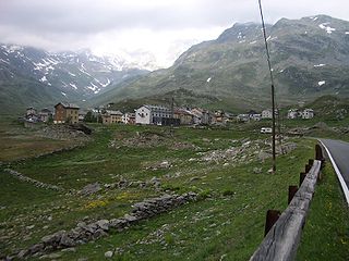
Montespluga is an Alpine village near the head of the Valle Spluga in the Italian region of Lombardy. It is a frazione of the comune of Madesimo, located at 1,908 m of altitude on the road to Chiavenna.
The Rheinwaldhorn is the highest point in the Swiss canton of Ticino at 3,402 metres above sea level. It lies on the border between the cantons of Graubünden and Ticino, in the Adula massif, part of the St. Gotthard massif of the Lepontine Alps in southern Switzerland.

The Aarmassif or Aaremassif is a geologic massif in the Swiss Alps. It contains a number of large mountain chains and parts of mountain chains.
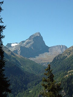
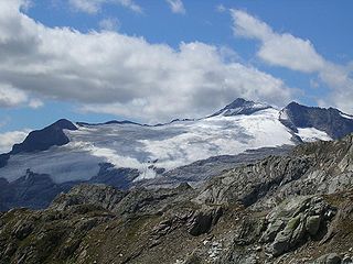
Monte Leone is the highest mountain of the Lepontine Alps and is located on the border between Switzerland and Italy. The mountain stands on the extreme west of the Lepontine Alps, a few kilometres east of Simplon Pass.
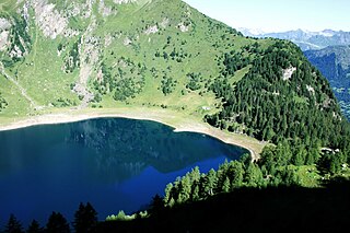
Tremorgio Lake is a mountain lake above Rodi and Fiesso, in the municipality of Prato Leventina in the canton of Ticino, Switzerland. Its surface area is 39 ha.

The Swiss Alpine Club is the largest mountaineering club in Switzerland. It was founded in 1863 in Olten and it is now composed of 111 sections with 160,000 members (2020). These include the Association of British Members of the Swiss Alpine Club.
The Basòdino is a mountain in the Lepontine Alps on the border between Italy and Switzerland. It is the second highest peak in the canton of Ticino, after the Rheinwaldhorn.

Piz Medel is a mountain in the Lepontine Alps, located on the border between the cantons of Ticino and Graubünden. At 3,210 metres (10,531 ft) above sea level it is the highest summit on the chain between Lukmanier Pass and Crap la Crusch. The mountain overlooks the Greina, an important pass connecting the cantons of Graubünden and Ticino.
The Wasenhorn is a mountain of the Lepontine Alps, located on the border between Switzerland and Italy. It lies halfway between Brig and Varzo, just north of Monte Leone, in the Simplon Pass area. Politically the Wasenhorn is split between the municipalities of Ried-Brig and Varzo.
The Greina is a high mountain pass across the western Lepontine Alps, connecting Sumvitg in the canton of Graubünden in Switzerland and Olivone in the canton of Ticino. The pass lies between the Piz Medel on the north and Pizzo Marumo, Piz Terri on the south.

Tambohorn or Pizzo Tambo[ˈpittso ˈtambo] or Pizzo Tambò[ˈpittso tamˈbɔ] is a mountain located at the eastern extremity of the Lepontine Alps on the Swiss-Italian border. The mountain lies on the German-Italian language border, west of the Splügen Pass which divides the Western Alps from the Eastern Alps.

The Lugano Prealps are a mountain range in the western part of the Alps. They are located in Canton Ticino and in Lombardy.

Lombardy is an administrative region of Italy that is split into four geographic regions — mountains, alpine forest, and the upper and lower plains south of the Po river. These are crossed and dotted by dozens of rivers and lakes, the latter of which include some of the largest in Italy. The territory is the fourth largest in Italy by surface area with 24,000 square kilometres (9,300 sq mi).

The Monte Zeda is a mountain in the Lepontine Alps belonging to the Province of Verbano-Cusio-Ossola (Italy).

