
A mountain is an elevated portion of the Earth's crust, generally with steep sides that show significant exposed bedrock. A mountain differs from a plateau in having a limited summit area, and is larger than a hill, typically rising at least 300 metres above the surrounding land. A few mountains are isolated summits, but most occur in mountain ranges.

Chimborazo is a currently inactive stratovolcano in the Cordillera Occidental range of the Andes. Its last known eruption is believed to have occurred around 550 A.D.

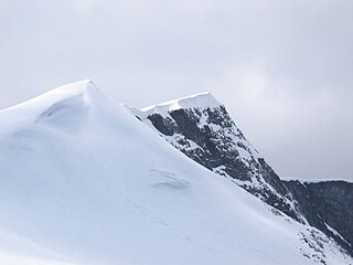
A summit is a point on a surface that is higher in elevation than all points immediately adjacent to it. The topographic terms acme, apex, peak, and zenith are synonymous.
Glittertind or Glittertinden is a mountain in Lom Municipality in Innlandet county, Norway. The 2,452-metre (8,045 ft) tall mountain is the second highest mountain in Norway. It is located in the Jotunheimen mountains within Jotunheimen National Park. The mountain sits about 22 kilometres (14 mi) southeast of the village of Fossbergom and about 38 kilometres (24 mi) southwest of the village of Vågåmo. The mountain is surrounded by several other notable mountains including Trollsteineggje, Trollsteinrundhøe, and Svartholshøe to the north; Grotbreahesten to the northeast; Veslekjølen to the east; Austre Hestlægerhøe and Nautgardstinden to the southeast; Steinbukampen and Veopallan to the south; and Galdhøpiggen to the west.

Nevado Ojos del Salado is a dormant complex volcano in the Andes on the Argentina–Chile border. It is the highest volcano in the world and the highest peak in Chile. The upper reaches of Ojos del Salado consist of several overlapping lava domes, lava flows and volcanic craters, with an only sparse ice cover. The complex extends over an area of 70–160 square kilometres (27–62 sq mi) and its highest summit reaches an altitude of 6,893 metres (22,615 ft) above sea level. Numerous other volcanoes rise around Ojos del Salado.
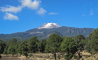
La Malinche, also known as Matlalcueye or Malintzin, is an active volcano located in the states of Tlaxcala and Puebla in Mexico. Officially, its summit reaches 4,461 metres (14,636 ft) above sea level, though it is generally considered to be closer to 4,440 metres (14,567 ft), using GPS measurements. It is the highest peak in Tlaxcala, the fifth-highest in Puebla, the sixth-highest in Mexico, the 23rd-highest in North America, and the 252nd-highest in the world. Its height above nearby cities varies from 1,908 metres (6,260 ft) above Huamantla, 2,461 metres (8,074 ft) above Villa Vicente Guerrero, 2,221 metres (7,287 ft) above Tlaxcala, to 2,299 metres (7,543 ft) above Puebla. The summit is 22.4 kilometres (13.9 mi) from Tlaxcala, 28.3 kilometres (17.6 mi) from Puebla, and 118 kilometres (73 mi) from Mexico City. The climate is cold near the summit and mild on the lower slopes.
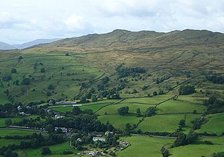
Wansfell is a fell in English Lake District situated 1½ miles east of the town of Ambleside. The fell is part of the long southern ridge of Caudale Moor and occupies the swath of territory between Ambleside and the Troutbeck valley.

Azufral is a stratovolcano located in the department of Nariño in southern Colombia, 12 km (7 mi) west of the town of Túquerres. It is the only volcano of the Western Ranges of the Colombian Andes. Its name derives from the Spanish word for sulfur, azufre. The volcano is considered semi-dormant but there are numerous fumaroles in the summit crater. The summit of the volcano has an altitude of 4,070 metres (13,350 ft), and the north-western side of the crater contains a crescent-shaped lake named Laguna Verde at 3,970 m (13,025 ft). The lake is 1,100 m (0.68 mi) long and 600 metres (2,000 ft) wide. and its bright green color is a result of the sulfur and iron-based deposits in the crater. There are also two other much smaller lakes in the crater, Laguna Negra and Laguna Cristal.

An ultra-prominent peak, or Ultra for short, is a mountain summit with a topographic prominence of 1,500 metres (4,900 ft) or more; it is also called a P1500. The prominence of a peak is the minimum height of climb to the summit on any route from a higher peak, or from sea level if there is no higher peak. There are approximately 1,524 such peaks on Earth. Some well-known peaks, such as the Matterhorn and Eiger, are not Ultras because they are connected to higher mountains by high cols and therefore do not achieve enough topographic prominence.

The topographic isolation of a summit is the minimum distance to a point of equal elevation, representing a radius of dominance in which the peak is the highest point. It can be calculated for small hills and islands as well as for major mountain peaks and can even be calculated for submarine summits.

This article comprises three sortable tables of major mountain peaks of Canada.

The Mount Royal Range is a mountain range in the Hunter region of New South Wales, Australia.

Thomas Cole Mountain is a mountain in Greene County, New York. The mountain is named after the artist Thomas Cole (1801–1848), who lived in the area and is regarded as the founder of the Hudson River School.
The Setzehorn is a mountain of the Bernese Alps, located north of Bellwald in the canton of Valais. It lies south of the Galmihorn, on the range lying between the Fiescher Glacier and the main Rhone valley.
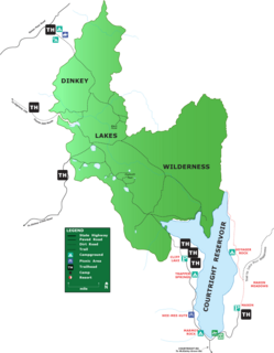
The Dinkey Lakes Wilderness is a federally designated wilderness area located 45 miles (72 km) northeast of Fresno, in the state of California, United States. It comprises 30,000 acres (12,141 ha) within the Sierra National Forest and was added to the National Wilderness Preservation System by the California Wilderness Act of 1984.
The Ritzihorn is a mountain of the Bernese Alps, overlooking Reckingen in the canton of Valais. It lies on the range south of the Galmihorn.

Missouri Buttes are located in Crook County in northeast Wyoming on the northwest flank of the Black Hills Uplift. The buttes are 3.5 miles (5.6 km) northwest (N60°W) of Devils Tower between the Little Missouri and the Belle Fourche rivers.

