A valley is a low area between hills or mountains typically with a river running through it. In geology, a valley or dale is a depression that is longer than it is wide. The terms U-shaped and V-shaped are descriptive terms of geography to characterize the form of valleys. Most valleys belong to one of these two main types or a mixture of them, at least with respect to the cross section of the slopes or hillsides.

Geologically, a fjord or fiord is a long, narrow inlet with steep sides or cliffs, created by a glacier. There are many fjords on the coasts of Alaska, Antarctica, British Columbia, Chile, Greenland, the Faroe Islands, Iceland, Kamchatka, the Kerguelen Islands, New Zealand, Norway, Novaya Zemlya, Labrador, Nunavut, Newfoundland, Quebec, Scotland, South Georgia Island, and Washington state. Norway's coastline is estimated at 29,000 kilometres (18,000 mi) with nearly 1,200 fjords, but only 2,500 kilometres (1,600 mi) when fjords are excluded.

Troms (pronounced [trʊms] or Romsa or Tromssa is a county in northern Norway. It borders Finnmark county to the northeast and Nordland county in the southwest. Norrbotten Län in Sweden is located to the south and further southeast is a shorter border with Lapland Province in Finland. To the west is the Norwegian Sea.

Oppland[²ɔplɑn](listen) is a county in Norway, bordering Trøndelag, Møre og Romsdal, Sogn og Fjordane, Buskerud, Akershus, Oslo and Hedmark. The county administration is in Lillehammer. Oppland is, together with Hedmark, one of the only two landlocked counties of Norway.
Folldal is a municipality in Hedmark county, Norway. It is part of the traditional region of Østerdalen. It is bordered on the north by Oppdal and Tynset municipalities, in the east by Alvdal municipality, in the south by Stor-Elvdal, Sør-Fron and Sel municipalities, and in the west by Dovre municipality. The administrative centre of the municipality is the village of Folldal. Mining at the Folldal mines was the main industry for Folldal's residents from the 18th century until the last mine related operation in 1993. The new municipality of Folldal was separated from Alvdal in 1914.

Voss (help·info) is a municipality and a traditional district in Hordaland county, Norway. The administrative center of the municipality is the village of Vossevangen. Other villages include Bolstadøyri, Borstrondi, Evanger, Kvitheim, Mjølfjell, Oppheim, Stalheim, and Vinje.

Vaksdal (help·info) is a municipality in the county of Hordaland, Norway. It is located in the traditional district of Nordhordland. The administrative centre is the village of Dalekvam. Other villages in Vaksdal include Dalegarden, Flatkvål, Helle, Nesheim, Stamneshella, Stanghelle, and Vaksdal.

Modalen is a municipality in the Nordhordland district in the northern part of Hordaland county in Norway. The administrative centre of the municipality is the village of Mo. The other main village in the municipality is Øvre Helland. Most of the residents of Modalen live in the main Modalen valley which extends eastwards from the end of the Romarheimsfjorden.

Kvinesdal is a municipality in Vest-Agder county, Norway. It is located in the traditional district of Lister. The administrative centre of the municipality is the village of Liknes. Other villages in Kvinesdal include Feda, Fjotland, Knaben, and Storekvina.
Mandal (help·info) is a municipality in Vest-Agder county, Norway. It is located in the traditional district of Sørlandet. Mandal is the southernmost municipality in all of Norway, with the tiny skerry of Pysen being the southernmost point of land in Norway.

Surnadal (help·info) is a municipality in Møre og Romsdal county, Norway. It is part of the Nordmøre region. The administrative centre is the village of Skei. Other villages in Surnadal include Glærem, Mo, Stangvik, Surnadalsøra, Sylte, Todalsøra, and Åsskard.

Åmli is a municipality in the county of Aust-Agder, Norway. It is located in the traditional region of Sørlandet. The main population centre and administrative center is the village of Åmli which lies along the river Nidelva. Other villages in Åmli include Askland, Dølemo, Eppeland, Flaten, Hillestad, Homdrom, Lauveik, Nelaug, Øvre Ramse, Skjeggedal, Tveit, Vehus, and Ytre Ramse.

Målselv is a municipality in Troms county, Norway. The administrative centre of the municipality is the village of Moen. The main commercial centre of the municipality is the Bardufoss area. Other villages in the municipality include Alappmoen, Fossmoen, Holmen, and Skjold. Besides bordering Sweden to the east and the ocean to the northwest, it borders the municipalities of Balsfjord, Storfjord, Bardu, Sørreisa, and Lenvik.
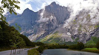
The Rauma is a river that runs through Romsdalen, a valley in Møre og Romsdal and Oppland counties in Norway. It runs for 68 kilometres (42 mi) from Lesjaskogsvatnet, a lake in the municipality of Lesja, to the town of Åndalsnes in the municipality of Rauma. The river was once famous for its salmon-fishing, but since an infection with Gyrodactylus salaris only 5 to 10% of the original stock survives. The salmon runs up to the Slettafossen, a 16-metre (52 ft) high combination of waterfalls and rapids more than 42 kilometres (26 mi) upriver from the estuary.

In geology, a graben is a depressed block of the crust of a planet bordered by parallel faults.

Gudbrandsdalen is a valley and traditional district in the Norwegian county of Oppland. The valley is oriented in a north-westerly direction from Lillehammer and the lake of Mjøsa, extending 230 kilometers (140 mi) toward Romsdalen. The river of Gudbrandsdalslågen (Lågen) flows through the valley, starting from Lesjaskogsvatnet and ending at Mjøsa. The Otta river flowing through Otta valley is a major tributary to Lågen. The valleys of the tributary rivers such as Otta and Gausa (Gausdal) are usually regarded as part of Gudbrandsdalen. The total area of the valley is calculated from the areas of the related municipalities. Gudbrandsdalen is the main valley in a web of smaller valleys. On the western side there are long adjacent valleys: Ottadalen stretches 100 km from Otta village, Gausdal some 50 km from Lillehammer and Heidal some 40 km from Sjoa. Gudbrandsdalen runs between the major mountain ranges of Norway including Jotunheimen and Dovrefjell-Rondane.
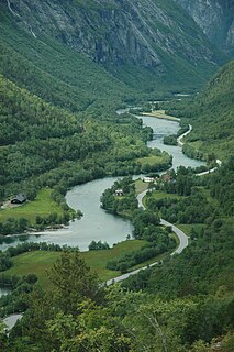
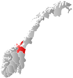
Romsdalen is a valley in Norway. The 60-kilometre (37 mi) long valley runs through Rauma Municipality in Møre og Romsdal county and Lesja Municipality in Oppland county. It is the valley of the Rauma river, from Old Norse Raumsdalr. The traditional district of Romsdal, which makes up about one-third of Møre og Romsdal county, is named for the valley of Romsdalen. The main road E136 and the Rauma line runs along the valley floor.
Orkland is a former municipality in the old Sør-Trøndelag county, Norway. The municipality existed only for a short time, from 1920 until 1963. The 169-square-kilometre (65 sq mi) municipality encompassed the southern third of what is now the municipality of Orkdal in Trøndelag county. The main church of the municipality was Moe Church, just south of the village of Vormstad, the administrative centre of the municipality. Most of the population lived in the Orkdalen valley along the river Orklaelva and near the lake Hostovatnet. The main village areas were Vormstad, Svorkmo, and Hoston.

U-shaped valleys, trough valleys or glacial troughs, are formed by the process of glaciation. They are characteristic of mountain glaciation in particular. They have a characteristic U shape, with steep, straight sides and a flat or rounded bottom. Glaciated valleys are formed when a glacier travels across and down a slope, carving the valley by the action of scouring. When the ice recedes or thaws, the valley remains, often littered with small boulders that were transported within the ice, called glacial till or glacial erratic.