Augustowo is a village in the administrative district of Gmina Dobrcz, within Bydgoszcz County, Kuyavian-Pomeranian Voivodeship, in north-central Poland. It lies 6 kilometres (4 mi) south-west of Dobrcz and 14 km (9 mi) north-east of Bydgoszcz.
Chełmszczonka is a village in the administrative district of Gmina Dobrcz, within Bydgoszcz County, Kuyavian-Pomeranian Voivodeship, in north-central Poland. It lies 6 kilometres (4 mi) south-east of Dobrcz and 18 km (11 mi) north-east of Bydgoszcz.
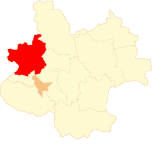
Świętosław is a village in the administrative district of Gmina Chełmża, within Toruń County, Kuyavian-Pomeranian Voivodeship, in north-central Poland. It lies approximately 11 kilometres (7 mi) east of Chełmża and 24 km (15 mi) north of Toruń.
Zaradowiska is a village in the administrative district of Gmina Wąbrzeźno, within Wąbrzeźno County, Kuyavian-Pomeranian Voivodeship, in north-central Poland. It lies approximately 7 kilometres (4 mi) south of Wąbrzeźno and 33 km (21 mi) north-east of Toruń.
Kolonia Bujnice is a settlement in the administrative district of Gmina Gorzkowice, within Piotrków County, Łódź Voivodeship, in central Poland.
Józefów is a village in the administrative district of Gmina Biała Rawska, within Rawa County, Łódź Voivodeship, in central Poland. It lies approximately 6 kilometres (4 mi) east of Biała Rawska, 23 km (14 mi) east of Rawa Mazowiecka, and 76 km (47 mi) east of the regional capital Łódź.
Olewin is a village in the administrative district of Gmina Wieluń, within Wieluń County, Łódź Voivodeship, in central Poland. It lies approximately 5 kilometres (3 mi) east of Wieluń and 84 km (52 mi) south-west of the regional capital Łódź.
Nowe Młyny is a settlement in the administrative district of Gmina Parzęczew, within Zgierz County, Łódź Voivodeship, in central Poland.
Brzozowo-Maje is a village in the administrative district of Gmina Dzierzgowo, within Mława County, Masovian Voivodeship, in east-central Poland.
Izdebki-Wąsy is a village in the administrative district of Gmina Zbuczyn, within Siedlce County, Masovian Voivodeship, in east-central Poland. It lies approximately 10 kilometres (6 mi) east of Zbuczyn, 22 km (14 mi) east of Siedlce, and 108 km (67 mi) east of Warsaw.
Wiktorów is a village in the administrative district of Gmina Radzymin, within Wołomin County, Masovian Voivodeship, in east-central Poland. It lies approximately 4 kilometres (2 mi) east of Radzymin, 8 km (5 mi) north of Wołomin, and 27 km (17 mi) north-east of Warsaw.
Ciemno-Gnojna is a village in the administrative district of Gmina Mszczonów, within Żyrardów County, Masovian Voivodeship, in east-central Poland.
Józefów Ochelski is a village in the administrative district of Gmina Pogorzela, within Gostyń County, Greater Poland Voivodeship, in west-central Poland.
Łąkie is a village in the administrative district of Gmina Rakoniewice, within Grodzisk Wielkopolski County, Greater Poland Voivodeship, in west-central Poland. It lies approximately 6 kilometres (4 mi) south-west of Rakoniewice, 18 km (11 mi) south-west of Grodzisk Wielkopolski, and 58 km (36 mi) south-west of the regional capital Poznań.
Kuszyn is a village in the administrative district of Gmina Mycielin, within Kalisz County, Greater Poland Voivodeship, in west-central Poland.
Anusin is a settlement in the administrative district of Gmina Wyrzysk, within Piła County, Greater Poland Voivodeship, in west-central Poland. It lies approximately 3 kilometres (2 mi) west of Wyrzysk, 33 km (21 mi) east of Piła, and 86 km (53 mi) north of the regional capital Poznań.
Młynki is a settlement in the administrative district of Gmina Skoki, within Wągrowiec County, Greater Poland Voivodeship, in west-central Poland.
Drzewicz is a village in the administrative district of Gmina Chojnice, within Chojnice County, Pomeranian Voivodeship, in northern Poland. It lies approximately 17 kilometres (11 mi) north of Chojnice and 90 km (56 mi) south-west of the regional capital Gdańsk.
Pierszczewo is a village in the administrative district of Gmina Stężyca, within Kartuzy County, Pomeranian Voivodeship, in northern Poland. It lies approximately 7 kilometres (4 mi) east of Stężyca, 16 km (10 mi) south-west of Kartuzy, and 42 km (26 mi) west of the regional capital Gdańsk.
Łaszka is a village in the administrative district of Gmina Sztutowo, within Nowy Dwór Gdański County, Pomeranian Voivodeship, in northern Poland. It lies approximately 5 kilometres (3 mi) south-east of Sztutowo, 12 km (7 mi) north-east of Nowy Dwór Gdański, and 40 km (25 mi) east of the regional capital Gdańsk.