Related Research Articles

Hagåtña, formerly Agana or Agaña, is a coastal village and the capital of the United States territory of Guam. From the 18th through mid-20th century, it was Guam's population center, but today, it is the second smallest of the island's 19 villages in both area and population. However, it remains one of the island's major commercial districts in addition to being the seat of government.

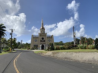
The Metropolitan Archdiocese of Agaña is a Latin Church ecclesiastical territory or diocese. It comprises the United States dependency of Guam. The prelate is an archbishop whose cathedral is the Dulce Nombre de Maria Cathedral-Basilica.

Tumon is a district located on Tumon Bay along the northwest coast of the United States unincorporated territory of Guam. Located in the municipality of Tamuning, it is the center of Guam's tourist industry.

Agana Heights is one of the nineteen villages in the United States territory of Guam. It is located in the hills south of Hagåtña, in the central part of the island. United States Naval Hospital Guam is located in this largely residential village.

Sinajana is the smallest of the nineteen villages in the United States territory of Guam by area. It is located in the hills south of Hagåtña. The village's name may have come from the word "china-jan," cookware used to cook wild yams that once grew in the area.

The Guam Department of Education (GDOE), formerly the Guam Public School System, is a school district that serves the United States territory of Guam. The school district can be thought of as analogous to the school districts of other cities and communities in the United States, but in some manners, it can also be thought of as analogous to the state education agencies of other states and territories.

Guam Highway 1 (GH-1), also known as Marine Corps Drive, is one of the primary automobile routes in the United States territory of Guam. It runs in a southwest-to-northeast direction, from the main gate of Naval Base Guam in the southwestern village of Santa Rita in a northeasterly direction to the main gate of Andersen Air Force Base in the village of Yigo. It passes through Guam's capital, Hagåtña, as well as intersecting other territorial highways. The highway runs through tropical forest, urbanized commercial areas, and residential neighborhoods. The US military upgraded and extended the road starting in 1941. Construction ceased with the Japanese invasion in December 1941 and resumed after the Second Battle of Guam in 1944. The highway was formally dedicated to the U.S. Marine Corps by the governor in 2004.
The area code 671 is the local telephone area code of the United States territory of Guam. It was created with the beginning of permissive dialing on July 1, 1997, replacing Guam's previous International Telecommunication Union country code 671 at the end of permissive dialing on July 1, 1998.
Southern High School is a public secondary school located at 1 Jose Perez Leon Guerrero Drive in the village of Santa Rita, in the United States territory of Guam. The school, a part of the Guam Public School System, opened in 1997 and serves grades 9 through 12. Southern High serves the villages of Santa Rita, Agat, Asan-Maina, Inarajan, Merizo, Piti, Talofofo, Umatac, and Yona.

Talo'fo'fo, formerly Talofofo, is a village located in the southern part of the United States territory of Guam, on the east coast. The village center is located in the hills above the coast, while the smaller coastal community below the cliff is known as Ipan.
Inalåhan is a village located on the southeastern coast of the United States territory of Guam. The village's original Chamoru name, Inalåhan, was altered when transliterated during Spanish control of the island.

The Guam Museum, formally the Senator Antonio M. Palomo Guam Museum & Chamorro Educational Facility, is a museum focusing on the history of Guam, a U.S. territory in Micronesia. A permanent building to house the museum's collection opened in Hagåtña on November 4, 2016. The Guam Museum had been housed in temporary locations since World War II.
Felix Flores Ungacta was a Guamanian politician and businessman. He served as the mayor of Hagåtña, the capital city and seat of government of Guam, from January 5, 1981 to January 3, 2005, becoming one of the territory's longest-serving mayors in history. The village's name was changed from Agana to Hagåtña in 1998, while the office he held was renamed from Commissioner to Mayor during his tenure. He was a member of the Republican Party of Guam.

Typhoon Alice was a typhoon that brought severe flooding to Guam during the latter part of the 1953 Pacific typhoon season. The system was first tracked near the Marshall Islands on October 11 by the Fleet Weather Central (FWC) as a tropical storm, and the Central Meteorological Observatory (CMO) as a tropical depression. The CMO upgraded Alice to a tropical storm east of Guam on October 14. One day later, and the FWC reported that the storm had intensified to 65 knots, equivalent to a Category 1 typhoon on the Saffir–Simpson scale. Near Iwo Jima, the typhoon traveled northeastwards, reaching its peak of 100 kn late on October 18. Alice then steadily weakened down to a tropical storm on October 20. The storm became extratropical on October 23 near the International Date Line, and both agencies ceased tracking the cyclone.
United States Naval Hospital Guam is a U.S. Navy medical facility on the U.S. territory of Guam. It provides a broad range of medical services to active-duty U.S. military personnel under Joint Region Marianas. Besides the main hospital, the hospital runs a medical clinic and a dental clinic on Naval Base Guam.

Liberation Day on the U.S. territory of Guam is an annual commemoration of the invasion by U.S. military forces on July 21, 1944, which ended the Japanese occupation that had begun in 1941. Begun in 1945, it is Guam's largest celebration. Festivities include a queen contest, summer carnival, fireworks display, and mile-long parade on Marine Corps Drive in Hagåtña from Adelup to Paseo de Susana, as well as solemn memorials and visits to massacre sites. It is organized by the Guam Island Fair Committee.

Latte Stone Park, officially Senator Angel Leon Guerrero Santos Latte Stone Memorial Park, is an urban park in Hagåtña, Guam. Established in the 1950s and operated by the Guam Department of Parks and Recreation, it is best known for its set of eight historical latte stones, which were transferred from their original site in Fena. The Park is located along the cliffline below the Governor's residence in Agana Heights and south of the Plaza de España. It is often visited by sightseers visiting central Hagåtña. The park also includes the entrances to two sets of caves that were constructed during the Japanese occupation (1941–1944) by forced laborers and that were listed in the National Register of Historic Places in 1991 as the Agana/Hagåtña Cliffline Fortifications.
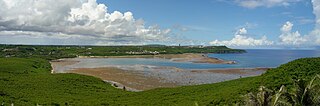
Pago Bay is the largest bay on the U.S. territory of Guam, located at the mouth of Pago River on the island's eastern coast. There is extensive evidence of CHamoru settlement before Spanish colonization during the late seventeenth century. During the Spanish-Chamorro Wars, the Spanish transferred the populations of Tinian and Aguigan to the village of Pago. However, a smallpox epidemic in 1856 killed much of the village's population and the Spanish moved survivors to other villages, leaving the bay shoreline largely uninhabited. The bay is popular with fishermen and recreationalists, and was the site of new housing development in the 2000s.
References
- ↑ "Contact Us Archived 2011-07-21 at the Wayback Machine ." Guam Department of Parks and Recreation. Retrieved on October 21, 2010. "Department of Parks and Recreation Headquarters / Administration Office 490 Chalan Palasyo Agaña Heights, Guam 96910."
- ↑ Losinio, Louella (26 February 2021). "DPR: 16 parks not maintained due to lack of funds". PNC News First. Retrieved 1 March 2021.
- 1 2 3 4 5 6 7 8 9 10 11 12 13 14 Sablan, Jerick (May 30, 2020). "Public parks open, but restrooms are closed for renovation". Pacific Daily News. Retrieved 1 March 2021.
- 1 2 3 4 5 6 Sablan, Jerick (June 28, 2020). "Many park restrooms still closed, renovations ongoing". Pacific Daily News. Retrieved 1 March 2021.