The Federal Highway is a highway in New South Wales and the Australian Capital Territory. It is a part of a motorway standard link between Sydney and Canberra, and is also the main thoroughfare between those cities.

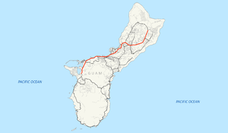
Guam Highway 1 (GH-1), also known as Marine Corps Drive, is one of the primary automobile routes in the United States territory of Guam. It runs in a southwest-to-northeast direction, from the main gate of Naval Base Guam in the southwestern village of Santa Rita in a northeasterly direction to the main gate of Andersen Air Force Base in the village of Yigo. It passes through Guam's capital, Hagåtña, as well as intersecting other territorial highways. The highway runs through tropical forest, urbanized commercial areas, and residential neighborhoods. The US military upgraded and extended the road starting in 1941. Construction ceased with the Japanese invasion in December 1941 and resumed after the Second Battle of Guam in 1944. The highway was formally dedicated to the U.S. Marine Corps by the governor in 2004.
Guam Highway 2 is one of the primary automobile routes in the United States territory of Guam.
Guam Highway 4 (GH-4) is one of the primary automobile highways in the United States territory of Guam.

State Route 229 is an east-west state highway in the central part of the U.S. state of Ohio. The western terminus of State Route 229 is at a T-intersection with State Route 47 just 0.25 miles (0.40 km) south of the village limits of Waldo. Its eastern terminus is more than 50 miles (80 km) to the east at a T-intersection with U.S. Route 36 about 5.5 miles (8.9 km) west of the village of Nellie.
Guam Highway 3 (GH-3) is one of the primary automobile highways in the United States territory of Guam.
Guam Highway 6 (GH-6) is one of the primary automobile highways in the United States territory of Guam. It is known alternately as Spruance Drive and Halsey Drive: both named for noteworthy US Navy Admirals that served in the Pacific Ocean theater of World War II: Raymond A. Spruance and William Halsey Jr., respectively.
Guam Highway 7 (GH-7) is one of the primary automobile highways in the United States territory of Guam.
Guam Highway 8 (GH-8) is one of the primary automobile highways in the United States territory of Guam.
Guam Highway 11 (GH-11) is one of the primary automobile highways in the United States territory of Guam.
Guam Highway 9 (GH-9) is one of the primary automobile highways in the United States territory of Guam.
Guam Highway 10 (GH-10) is one of the primary automobile highways in the United States territory of Guam.
Guam Highway 16 (GH-16), also named Army Drive, is one of the primary automobile highways in the United States territory of Guam.
Guam Highway 10A (GH-10A) is one of the primary automobile highways in the United States territory of Guam.
Guam Highway 17 (GH-17) is one of the primary automobile highways in the United States territory of Guam.
Guam Highway 18 (GH-18) is one of the primary automobile highways in the United States territory of Guam.
Guam Highway 12 (GH-12) is one of the primary automobile highways in the United States territory of Guam.
Guam Highway 15 (GH-15) is one of the primary automobile highways in the United States territory of Guam.
Guam Highway 14 (GH-14) is one of the primary automobile highways in the United States territory of Guam.
Guam Highway 27 (GH-27), also known as Hamburger Highway or Harmon Loop Road, is a short highway in the United States territory of Guam. The highway runs in an east–west direction from a junction with GH-16 to a junction with GH-1, and is located almost entirely in the southern region of the city of Dededo. The highway gets its name from the fact that it provides access to a large McDonald's restaurant located at the intersection with GH-16.


