
Milne Bay is a province of Papua New Guinea. Its capital is Alotau. The province covers 14,345 km² of land and 252,990 km² of sea, within the province there are more than 600 islands, about 160 of which are inhabited. The province has about 276,000 inhabitants, speaking about 48 languages, most of which belong to the Eastern Malayo-Polynesian branch of the Austronesian language family. Economically the province is dependent upon tourism, oil palm, and gold mining on Misima Island; in addition to these larger industries there are many small-scale village projects in cocoa and copra cultivation. The World War II Battle of Milne Bay took place in the province.
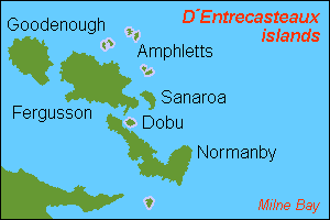
D'Entrecasteaux Islands are situated near the eastern tip of New Guinea in the Solomon Sea in Milne Bay Province of Papua New Guinea. The group spans a distance of 160 km (99 mi), has a total land area of approximately 3,100 km2 (1,197 sq mi) and is separated from the Papua New Guinea mainland by the 30 km (19 mi) wide Ward Hunt Strait in the north and the 18 km (11 mi) wide Goschen Strait in the south. D'Entrecasteaux Islands show signs of volcanism.
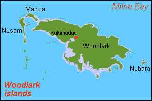
Madau is an island of the Woodlark Islands group, in the Solomon Sea and Milne Bay Province of Papua New Guinea.
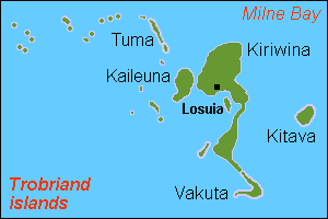
Kiriwina is the largest of the Trobriand Islands, with an area of 290.5 km². It is part of the Milne Bay Province of Papua New Guinea. Most of the 12,000 people who live in the Trobriands live on Kiriwina. The Kilivila language, also known as Kiriwina, is spoken on the island. The main town is Losuia. The island falls under the administrative division of Kiriwina Rural LLG.

Samarai is an island and former administrative capital in Milne Bay Province, Papua New Guinea.

Operation Chronicle was the Allied invasion of Woodlark and Kiriwina Islands, in the South West Pacific, during World War II. The operation was a subordinate action that formed part of the wider Operation Cartwheel, the advance towards Rabaul. An early planning name for this operation was Operation Coronet. Preliminary actions commenced on 23–24 June 1943 when small reconnaissance parties were landed on both islands. The main operation was executed without opposition on 30 June 1943. Around 16,800 personnel took part, divided into two forces. The United States Army provided the majority of ground troops, which were supported by a United States Marine Corps defense battalion as well as U.S. and Australian aircraft and naval vessels.

The Anglican Church of Papua New Guinea is a province of the Anglican Communion. It was created in 1977 when the Province of Papua New Guinea became independent from the Province of Queensland in the Church of England in Australia following Papua New Guinea's independence in 1975.
Woodlark Island, known to its inhabitants simply as Woodlark or Muyua, is the main island of the Woodlark Islands archipelago, located in Milne Bay Province and the Solomon Sea, Papua New Guinea.

The Panniet naked-backed fruit bat, also known as the De Vis's Bare-backed Fruit Bat and Panaeati Bare-backed Fruit Bat, is a species of megabat in the family Pteropodidae. It roosts in groups, within caves and tree hollows.
Guasopa Airport, is an airport at Guasopa on Woodlark Island, in the Milne Bay Province, Papua New Guinea.
Samarai-Murua District is a district of the Milne Bay Province of Papua New Guinea. Its capital is Murua. The population of the district was 58,590 at the 2011 census.

HMAS Ladava is a former Royal Australian Navy (RAN) base that was located at Milne Bay in Papua New Guinea.

Nacaduba cyanea, the tailed green-banded line-blue, is a species of butterfly in the family Lycaenidae, and formerly considered a member of the genus Danis. It is found in the Indonesia, Papua New Guinea, the Solomon Islands and Australia (Queensland).
Kulumadau is a large, rural non-village on Woodlark Island, Milne Bay Province Papua New Guinea. It is served by Guasopa Airport. Its population during the 1990 census was 242, though it has since grown extensively; its current population is reported to be about 2,500 people, but there are no official sources for this number, as the last official census was taken in 1990. There is a large primary school in Kulumadau, where 200 students are taught. Students must travel to Alotau on the mainland to attend secondary school. Kulumadau was built in the post-colonial times, and as such, is not considered a traditional village of Woodlark, however, since its inception, Kulumadau has been the primary population center on Woodlark Island.
Matilda Pilacapio is a human rights activist and an environmental rights activist from Papua New Guinea (PNG). A former member of the provincial government of Milne Bay Province, she is particularly known for her campaigns against the oil palm industry. More recently she has been active in the Papua Hahine Social Action Forum, a group campaigning against gender-based violence.
Sir Charles Lepani is a former public servant and diplomat from Papua New Guinea. He was the country's high commissioner in Australia from 2005 to 2017 and, prior to that, had been its ambassador to both the European Union and several European countries.
Naval Base Milne Bay, also called Naval Advance Base Milne Bay, was new major United States Navy sea and airbase base built on Milne Bay in Milne Bay Province in south-eastern Papua New Guinea. By spring 1943, the build up of the US Navy to support the Pacific War had caused overcrowding at the ports on the east coast of Australia. To help, Seabees departed Naval Base Brisbane on June 19, 1943 to set up a new base in Milne Bay. Naval Base Milne Bay headquarters was at Ladava Navy Base. The Royal Australian Navy already had a small base in Milne Bay: HMAS Ladava. Australians were able to defend and keep Milne Bay in the Battle of Milne Bay in 1942. Naval Base Milne Bay was built during World War II to support the many ships and aircraft fighting and patrolling in the South West Pacific theatre of war. Ladava Navy Base provided a large protective US Navy fleet anchorage at Gahora Bay next to Ladava. At Naval Base Milne Bay, Seabees built a large Naval facility.
Naval Base Port Moresby was a United States Navy base built during World War II at the city of Port Moresby on Papua New Guinea. The US Navy built a communication center and advance base headquarters for the US Seventh Fleet to support the Pacific War in 1943. The base was part of the New Guinea campaign.

Naval Base Woodlark Island was a United States Navy base built during World War II on Woodlark Island on Papua New Guinea. The US Navy built a PT boat base, boat repair depot, and harbor facilities at the city of Guasopa to support the Pacific War in 1943. The Harbor facilities was also built to support the US Navy in building the Narewa Airfield on the island. The base was part of the New Guinea campaign.

US Naval Base New Guinea was number of United States Navy bases on the island of New Guinea during World War II. Australia entered World War II on 3 September 1939, being a self-governing nation within the British Empire. The United States formally entered the war on 7 December 1941, following the attack on Pearl Harbor by the Empire of Japan. Following the attack on Pearl Harbor, Japan quickly took over much of the South Pacific Ocean. The United States lost key naval bases in the South Pacific, including Naval Base Manila and Naval Base Subic Bay, both lost in the 1941–42 invasion of the Philippines. Also lost were Naval Base Guam and Wake Atoll. As such, the United States Armed Forces needed new bases in the South West Pacific for staging attacks on Japan's southern empire. The United States built bases first in Australia, then in New Guinea.
