The Gulf Coast of the United States, also known as the Gulf South or the South Coast, is the coastline along the Southern United States where they meet the Gulf of Mexico. The coastal states that have a shoreline on the Gulf of Mexico are Texas, Louisiana, Mississippi, Alabama, and Florida, and these are known as the Gulf States.
A gulf is a large inlet from the ocean into a landmass.
Columbia most often refers to:
Red River usually refers to one of the following:

Gulfport is the second-most populous city in the U.S. state of Mississippi after the state capital, Jackson. Along with Biloxi, Gulfport is the co-county seat of Harrison County and part of the Gulfport–Biloxi metropolitan area. As of the 2020 census, Gulfport has a population of 72,926; the metro area has a population of 416,259. Gulfport lies along the gulf coast of the United States in southern Mississippi, taking its name from its port on the Gulf Coast on the Mississippi Sound. It is home to the U.S. Navy Atlantic Fleet Seabees.
Gulf states may refer to:

During the Spanish colonization of the Americas, the Spanish Main was the collective term used by English speakers for the parts of the Spanish Empire that were on the mainland of the Americas and had coastlines on the Caribbean Sea or Gulf of Mexico. The term was used to distinguish those regions from the numerous islands Spain controlled in the Caribbean, which were known as the Spanish West Indies.

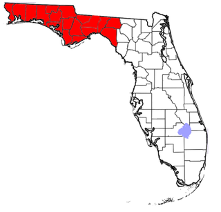
The Florida panhandle is the northwestern part of the U.S. state of Florida. It is a salient roughly 200 miles (320 km) long, bordered by Alabama on the north and the west, Georgia on the north, and the Gulf of Mexico to the south. Its eastern boundary is arbitrarily defined. It is defined by its southern culture and rural geography relative to the rest of Florida, as well as closer cultural links to French-influenced Louisiana, Mississippi, and Alabama. Its major communities include Pensacola, Navarre, Destin, Panama City Beach, and Tallahassee.

The West South Central states, colloquially known as the South Central states, is a region of the United States defined by the U.S. Census Bureau as covering four states: Arkansas, Louisiana, Oklahoma, and Texas. The West South Central or South Central region is located within the Southern United States and Gulf Coast regions, bordering the Mountain states and Midwestern U.S. regions to its north and west. The Gulf of Mexico is to the south of the region. Houston is the South Central's largest city, and the Dallas–Fort Worth–Arlington metropolitan statistical area is the region's largest metropolis.
Riviera is an Italian word which means 'coastline', ultimately derived from Latin rīpa, through Ligurian rivêa. It came to be applied as a proper name to the coast of Liguria, in the form Riviera ligure, then shortened in English.
Alonso Álvarez de Pineda was a Spanish conquistador and cartographer who was the first to prove the insularity of the Gulf of Mexico by sailing around its coast. In doing so he created the first map to depict what is now Texas and parts of the Gulf Coast of the United States.

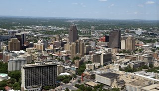
South Texas is a geographic and cultural region of the U.S. state of Texas that lies roughly south of—and includes—San Antonio. The southern and western boundary is the Rio Grande, and to the east it is the Gulf of Mexico. The population of this region is more than 5 million according to the 2024 census estimates. The southern portion of this region is often referred to as the Rio Grande Valley. The eastern portion along the Gulf of Mexico is also referred to as the Coastal Bend.

The Gulf Coastal Plain extends around the Gulf of Mexico in the Southern United States and eastern Mexico.

The Mississippi River Delta is the confluence of the Mississippi River with the Gulf of Mexico in Louisiana, southeastern United States. The river delta is a three-million-acre area of land that stretches from Vermilion Bay on the west, to the Chandeleur Islands in the east, on Louisiana's southeastern coast. It is part of the Gulf of Mexico and the Louisiana coastal plain, one of the largest areas of coastal wetlands in the United States. The Mississippi River Delta is the 7th largest river delta on Earth (USGS) and is an important coastal region for the United States, containing more than 2.7 million acres of coastal wetlands and 37% of the estuarine marsh in the conterminous U.S. The coastal area is the nation's largest drainage basin and drains about 41% of the contiguous United States into the Gulf of Mexico at an average rate of 470,000 cubic feet per second.

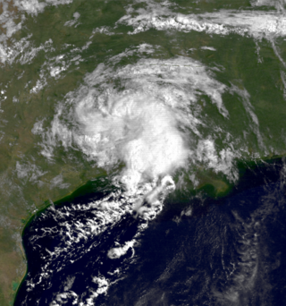
The 1987 Gulf Coast tropical storm caused flooding along the Gulf Coast of the United States. The second tropical cyclone and first tropical storm of the 1987 Atlantic hurricane season, it originated from a tropical wave in the Gulf of Mexico, southeast of Texas, on August 9. Initially a tropical depression, the cyclone moved north-northwestward and slightly intensified into a tropical storm later that day. By August 10, it made landfall between Galveston and Beaumont. The system weakened after moving inland and turned towards the east and later southeast. Briefly reemerging over the Gulf on August 15, the depression moved onshore a second time in Florida, before dissipating over eastern Georgia on August 17.

The Gulf of Mexico is an ocean basin and a marginal sea of the Atlantic Ocean, mostly surrounded by the North American continent. It is bounded on the northeast, north and northwest by the Gulf Coast of the United States; on the southwest and south by the Mexican states of Tamaulipas, Veracruz, Tabasco, Campeche, Yucatán, and Quintana Roo; and on the southeast by Cuba. The Southern U.S. states of Texas, Louisiana, Mississippi, Alabama, and Florida, which border the gulf on the north, are often referred to as the "Third Coast" of the United States.

Texas Gulf Coast is an intertidal zone which borders the coastal region of South Texas, Southeast Texas, and the Texas Coastal Bend. The Texas coastal geography boundaries the Gulf of Mexico encompassing a geographical distance relative bearing at 367 miles (591 km) of coastline according to CRS and 3,359 miles (5,406 km) of shoreline according to NOAA.

The Great Texas Coastal Birding Trail is a state-designated system of trails, bird sanctuaries, and nature preserves along the entire length of the Texas Gulf Coast in the United States. As the state of Texas hosts more bird species than any other state in the U.S. the trail system offers some of the most unusual opportunities for bird-watching in the world. The "trail" is actually 43 separate hiking and driving trails that include 308 birding sites. The sites themselves feature a variety of viewing opportunities with boardwalks, observation decks, and other amenities. The trails boast more than 450 bird species. The trail system is managed by the Texas Parks and Wildlife Department as part of the Great Texas Wildlife Trails which also include the Heart of Texas Wildlife Trail, the Panhandle Plains Wildlife Trail, and the Prairies and Pineywoods Wildlife Trail.
Gordon Pennington Gunter was an American marine biologist and fisheries scientist. He is noted for his pioneering study of fisheries in the northern Gulf of Mexico, a topic to which he devoted his entire professional life over a career spanning 60 years. His own research, and that of the scientists under his direction, established an understanding of the ecology, comparative physiology of the plant and animal life, and commercial fisheries of the region, and he coined the phrase "fertile fisheries crescent" to refer to Mississippi Sound and adjacent waters along the United States Gulf Coast. He also pioneered the study of the comparative physiology of shellfish and fish.


