Gun Hill Signal Station, St. George is the largest and most important of the military outposts in Barbados, with military associations from at least 1697. In the Militia Act of that year, when it was known as Briggs Hill, it was named as one of the four points where guns were to be placed to give alarm in the event of an invasion, so it is likely that the name Gun Hill goes back nearly 300 years.
When the signal stations were established in 1818–1819, it became the key link in the chain, passing signals from Highgate East to Moncrieffe on the cliffs of the St. John/St. Philip border, and north to the Cotton Tower, Grenade Hall, and Dover Fort (and vice versa). But Gun Hill was also the typical 'Hill Station' of the tropics, used as a convalescent station for the troops, and for evacuation of the Garrison in times of epidemics of yellow fever and once (in 1854) of cholera. There was only a small barrack, and mass evacuations went under canvas.
Lion sculpture
After the decline of the signal stations, the Gun Hill buildings fell into complete disrepair. They include the station with its prominent tower, a kitchen, magazine, sentry box, and ruined barracks. On the hillside below is a well-known sculpture of a lion. In 1981, the Barbados National Trust leased the station from the government and restored it with the help of a government grant.
Tropospheric scatter, also known as troposcatter, is a method of communicating with microwave radio signals over considerable distances – often up to 500 kilometres (310 mi) and further depending on frequency of operation, equipment type, terrain, and climate factors. This method of propagation uses the tropospheric scatter phenomenon, where radio waves at UHF and SHF frequencies are randomly scattered as they pass through the upper layers of the troposphere. Radio signals are transmitted in a narrow beam aimed just above the horizon in the direction of the receiver station. As the signals pass through the troposphere, some of the energy is scattered back toward the Earth, allowing the receiver station to pick up the signal.
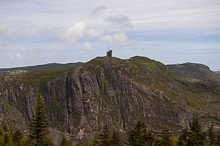
Signal Hill is a hill which overlooks the harbour and city of St. John's, Newfoundland and Labrador, Canada. The majority of Signal Hill, including Cabot Tower, is designated a National Historic Site. The highest point, Ladies' Lookout, is 167 m (548 ft) high.
The parish of Christ Church is one of eleven historic political divisions of Barbados. It has a land area of 57 km2 (22 sq mi) and is found at the southern end of the island. Christ Church has survived by name as one of the original six parishes created in 1629 by Governor Sir William Tufton.
Cabot Tower is a tower in St. John's, Newfoundland and Labrador, situated on Signal Hill. Construction of the tower began in 1898 to commemorate the 400th anniversary of John Cabot's landing in Newfoundland, and Queen Victoria's Diamond Jubilee.
Fort San Lucian, also known as Saint Lucian Tower or Fort Rohan, is a large bastioned watchtower and polygonal fort in Marsaxlokk, Malta. The original tower was built by the Order of Saint John between 1610 and 1611, being the second of six Wignacourt towers.
Blackhead Point, also known as Tai Pau Mai indigenously, or by the names Tsim Sha Tsui Point and Signal Hill (訊號山), was a cape before any land reclamation took place in Tsim Sha Tsui, Kowloon, Hong Kong. It currently remains a small hill near the coast.
The Marconi National Historic Site and the Marconi Wireless Station National Historic Site are two National Historic Sites located on Cape Breton Island, Nova Scotia. Both sites commemorate the efforts of Guglielmo Marconi to transmit transatlantic radio signals between North America and Europe in the first decade of the 20th century. The two sites are located within approximately 8 kilometres (5.0 mi) of one another, and are connected by the Marconi Trail.
Crab Hill is a settlement in Barbados, at the northern end of the parish of Saint Lucy. The place was so named because large numbers of crabs would appear in the area during rainfall; people would catch the crabs and keep them as pets. The population is 727 (2018), which makes it the most populous place in the parish of St. Lucy. Crab Hill is the site of the St. Lucy Police Station. The Mount Gay North Stars Cricket Ground is located in Crab Hill.
Pepperrell Air Force Base, previously known as Fort Pepperrell, is a decommissioned United States military base located in St. John's, Newfoundland, Canada which operated from 1941 to 1961.
The Battle of Abu Ghraib took place between Iraqi Mujahideen and United States forces at Abu Ghraib prison on April 2, 2005.
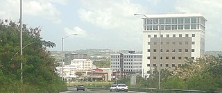
The City of Warrens located in the parish of Saint Michael is one of the fastest developing areas in the country of Barbados. In the span of a few years beginning around the year 2000, the Warrens, Saint Michael area has become synonymous with new money flowing into the country and for the development in the form of newly constructed tall buildings.
Glendairy Prison, also called Her Majesty's Prison, was the correctional facility located in the country of Barbados. The prison, which housed up to 1,000 male and female inmates, was located in Station Hill, St. Michael.
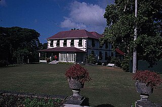
Francia Great House is a historical plantation great house in Saint George, Barbados. It is on a wooded hillside near Gun Hill Signal Station.
The following outline is provided as an overview of and introduction to Barbados:
Highlands Air Force Station was a military installation in Middletown Township near the borough of Highlands, New Jersey. The station provided ground-controlled interception radar coverage as part of the Lashup Radar Network and the Semi-Automatic Ground Environment network, as well as providing radar coverage for the Highlands Army Air Defense Site. The site's 240 acres (97 ha) is now the Rocky Point section in Hartshorne Woods Park of the Monmouth County Parks System.
The Barbados Wildlife Reserve is located in the parish of Saint Peter, Barbados. It occupies four acres of mahogany forest near the top of Farley Hill, next to Grenade Hall Signal Station and Forest.
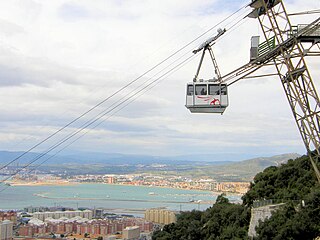
Gibraltar Cable Car is an aerial tramway in Gibraltar. The base station of the cable car is located near the southern end of Main Street, next to Alameda Gardens.
The Barbados Community College is a tertiary institution located on Eyrie Howells' Road, Saint Michael, Barbados.
Windmill Hill or Windmill Hill Flats is one of a pair of plateaux, known collectively as the Southern Plateaux, at the southern end of the British Overseas Territory of Gibraltar. It is located just to the south of the Rock of Gibraltar, which descends steeply to the plateau. Windmill Hill slopes down gently to the south with a height varying from 120 metres (390 ft) at the north end to 90 metres (300 ft) at the south end. It covers an area of about 19 hectares, though about 6 hectares at the north end is built over. The plateau is ringed to the south and east with a line of cliffs which descend to the second of the Southern Plateaux, Europa Flats, which is itself ringed by sea cliffs. Both plateaux are the product of marine erosion during the Quaternary period and subsequent tectonic uplift. Windmill Hill was originally on the shoreline and its cliffs were cut by the action of waves, before the ground was uplifted and the shoreline moved further out to the edge of what is now Europa Flats.
Lord Salisbury described Malta, Gibraltar, Bermuda, and Halifax as Imperial fortresses at the 1887 Colonial Conference, though by that point they had been so designated for decades. Later historians have also given the title "imperial fortress" to St. Helena and Mauritius.
This page is based on this Wikipedia article Text is available under the CC BY-SA 4.0 license; additional terms may apply. Images, videos and audio are available under their respective licenses.