
Bhojpur is one of the two urban municipalities of Bhojpur District of Province No. 1 of Nepal.
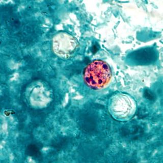
Cyclosporiasis is a disease caused by infection with Cyclospora cayetanensis, a pathogenic apicomplexan protozoan transmitted by feces or feces-contaminated food and water. Outbreaks have been reported due to contaminated fruits and vegetables. It is not spread from person to person, but can be a hazard for travelers as a cause of diarrhea.

Chitwan District is one of 77 districts of Nepal, and takes up the southwestern corner of Bagmati Province. Bharatpur, largest city of Nepal after Kathmandu, is its administrative centre. It covers 2,238.39 km2 (864.25 sq mi), and in 2011 had a population of 579,984 people. Bharatpur is the commercial and service centre of South Central Nepal and a major destination for higher education, health care and transportation in the region. Chitwan lies in the Terai region of Nepal. It is in the drainage basin of the Gandaki River and is roughly triangular, taking that river as its meandering northwestern border, and a modest watershed border, with India, as the basis of its southern limit. Local government: Bharatpur Metropolitan, Rapti Municipality, Ratnanagar Municipality, Kalika Municipality, Khairahani Municipality, Madi Municipality, Ikshyakamana Gaupalika
Bharatpur is a city in south central Nepal. It is the third most populous city of Nepal after Kathmandu and Pokhara with 369,377 inhabitants in 2021. It is also the second largest metropolitan city in Nepal by area. It is the district headquarter of the Chitwan District.
Ratnanagar is a municipality in Chitwan District of Bagmati Province in Nepal. It is the second biggest municipality after Bharatpur Metropolitan City that was formed in 1997 through the merger of the former Village Development Committees Old-Ratnanagar and Panchakanya. It is adjacent to Chitwan National Park, and serves as a gateway to the park. Agricultural products produced from Ratnanagar includes rice, maize, mustard and vegetables. This municipality is also a major place for production of poultry products and animal husbandry. Tourism is another source of income generation for the people in Ratnanagar. People are directly or indirectly dependent in tourism industry. Ratnanagar is also concerned in environment preservation so in order to preserve and protect environment, eco-friendly electric risk-shaw has also been introduced and available in different parts of this municipality. It lies on the bank of East Rapti River.
Chapakot is a municipality in the southeastern part of Syangja District in Gandaki Province of central Nepal. The new municipality was formed by merging three existing villages—Ratnapur, Kuwakot and Chapakot—on 18 May 2014. In 12 March 2017 The government implemented the new local administrative structure consisting of 744 local units. With the implementation of this new local administrative structure, the old structure will no longer be in existence. According to the new structure, VDCs will be replaced with village councils. Newly merged VDCs are Sankhar, Sekham, Ward no. 8 of Pakbadi & Ward no. of Malyangkot. The office of the municipality is that of the former Chapakot Municipality.
Birendranagar is a village development committee (VDC) in Chitwan District in the Narayani Zone of southern Nepal. At the time of the 2011 Nepal census it had a population of 14,934 people living in 3,374 individual households.
Chainpur is a town in Khairhani Municipality in Chitwan District in Bagmati Province of southern Nepal. The municipality was established on 18 May 2014 by merging the existing Khairahani Municipality, Kumroj and Chainpur VDCs. At the time of the 1991 Nepal census it had a population of 9960 people living in 1781 individual households.

Kumroj is a town in Khairhani Municipality in Chitwan District in the Narayani Zone of southern Nepal. The municipality was promulgated on 18 May 2014 by merging the existing Khairahani, Kumroj and Chainpur VDCs. Kumroj is 190 km south-west of the Kathmandu valley stationed in the Rapti valley, also known as the Inner Terai or Dun. The village is situated at an altitude of 1000 ft above the sea level surrounded by two mountain ranges; the mahabharat ranges of hills on the north and the churiya siwalik hills on the south. The main point of attraction is the Chitwan National Park which today stands as a successful testimony of nature conservation in south Asia Region. Historically it was established in 1973 as the first national park of the Nepal to preserve a unique ecosystems significantly valuable to the whole world en routing this area on the world heritage site list in 1984. In the near future, this town would be one of the potential Eco-tourism village destination. Kumroj is dedicated to protect the wild animals, community forest and the Chitwan national park. Once the Southern belt of Nepal was afflicted by malaria epidemics. Tharu, the native tribe, were able to thrive even in malaria. As malaria subsided, more and more people started migrating in this place in the search of arable land, which eventually made Kumroj as a multicultural and multiethinic place. Irrigated low land has been the main stud of agriculture, permitting Rice-Rice-Pulse cropping pattern feasible.
Parbatipur is a part of Bharatpur Metropolitan City-21 in Chitwan District in Bagmati Province of southern Nepal. At the time of the 2011 Nepal census it had a population of 6506 people living in 1614 individual households. Though the status of the settlement has not been announced publicly, the official fees and taxes are applied by Metropolitan City standard/rate. Parbatipur Town is only 18 km far from its district capital Bharatpur. It is one of the fastest-growing towns of West Chitwan.
Meghauli is a small city and former Village Development Committee that is now part of Bharatpur Metropolitan City in Bagmati Province of central Nepal.
Saradanagar(Nepali: शारदानगर) is a town in Bharatpur Metropolitan City in Chitwan District in the Bagmati Province of Nepal. The formerly Village Development Committee was merged to form new municipality, Chitrawan Municipality on 18 May 2014 by merging formerly Gunjanagar and Saradanagar village development committee, which was later merged under Bharatpur Metropolitan. At the time of the 1991 Nepal census it had a population of 7133 people living in 1334 individual households.
Shivanagar was a village development committee in Chitwan District in the Narayani Zone of southern Nepal. At the time of the 1991 Nepal census it had a population of 6,937 people living in 1,314 individual households.
Pathari Shanishchare (पथरी-शनिश्चरे) is a Municipality in Morang District in the Koshi Zone of south-eastern Nepal. It was formed by merging three existing village development committees i.e. Hasandaha, Pathari and Sanischare in May 2014.
Devchuli Municipality is a municipality in Nawalpur District in the southern part of Gandaki Province in Nepal. At the time of the 2011 Nepal census it had a population of 42,603 people living in 916 individual households. The municipality was established on 18 May 2014 by merging the preexisting Devchuli, Dibyapuri, Pragatinagar VDCs and later Rajahar VDC. The Narayani River flows in the vicinity. Northern side of the municipality is covered by hills with major population of ethnic Magar people and their culture. Northern areas are also least developed, rural and lack basic infrastructures, such as roads, hospitals and clean drinking water supply. Southern plain areas are developing and has major concentration of population. Municipality has great ethnic and cultural diversity, made of indigenous Tharu, Magar and all other major ethnic groups and culture residing harmoniously.
Popularly known as Daman or Palung or Tistung - Palung, Thaha Municipality is a municipality in Makwanpur District of Bagmati Province in mid Nepal. In Nepali Thaha, (थाहा) means to know. It was one of the biggest communist political movement led by hon. Rupchandra Bista. He started the Thaha Movement which is dedicated to his contributions to this region.
Chitrawan Municipality is a former Municipality in Chitwan District, now a part of Bharatpur Metropolitan City in Bagmati Province of southern Nepal. The Municipality was established on 18 May 2014 by merging formerly Gunjanagar, Saradanagar and Dibyanagar village development committee. At the time of the 2011 Nepal census, it had a population of 26,579 people living in 2025 individual households. The total population is 34,913. The total area is 54.9 km2.
Gaindakot is a municipality in Nawalpur District in the Lumbini Zone of southern Nepal. It became a municipality in May 2014 by merging the existing Mukundapur, Amarapuri, and Gaindakot VDCs. It was again expanded by merging Ratanpur VDC. It is situated on the shore of Narayani River in the lap of Maula Kalika temple. So this place has a great possibility of tourism development. At the time of the 2011 Nepal census, it had a population of 58,841 and 13,623 individual households according to 2011 Nepal census. Contributed in the article by Prashant Subedi
Khairahani is a municipality in Chitwan District in Bagmati Province of southern Nepal. The municipality was established on 8 May 2014 by merging the existing Khairahani, Kumroj and Chainpur VDCs. At the time of the 1991 Nepal census it had a population of 13,629 people living in 2262 households.
Rapti Municipality is a municipality which lies in Eastern part of Chitwan district in Bagmati Province of Nepal. It was formed as municipality in 2015 by merging five existing village development committees, Birendranagar VDC, Bhandara VDC, Piple VDC, Lothar VDC and Korak VDC. Total area of this municipality is 99.40 and population of this municipality according to 2068 BS census is 46510.
