
The Xagħra Stone Circle, also known as the Xagħra Hypogeum or the Brochtorff Circle, is a Neolithic funerary complex located in Xagħra, Gozo, Malta. It consists of a series of caves which were used to bury the dead, and which were surrounded by a walled enclosure. It mainly dates back to around 3000 to 2400 BC, although the earliest tombs at the site date back to 4100 to 3800 BC. The caves collapsed sometime before 2000 BC, and the site was later used for domestic and agricultural purposes.
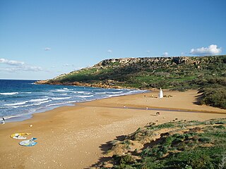
Ramla Bay is located at the bottom of a rich and fertile valley on the northern side of the island of Gozo. Gozo is one of the Maltese islands. The village of Xagħra, located on one of the hills of Gozo, overlooks this valley. It is about a forty-minute walk from Xagħra to the bay. The bay can also be reached from the village of Nadur. Bus service to the beach is very regular. The terraced walls built by the farmers give the valley an appearance of a quilt when viewed from the high ridges surrounding it.

Marsalforn, also written as M'Forn for shortcut purposes, is a village on the north coast of Gozo, the second largest island of the Maltese archipelago. The village lies between the hill-top towns of Xagħra and Żebbuġ. The village forms part of the locality of Żebbuġ. Marsalforn is one of the most popular tourist resorts on Gozo. It is well served with hotels, guest houses, restaurants, bars, and beaches. There is only a one small sandy beach in Marsalforn, however, along the rocky coastline there are a number of interesting swimming spots. Also, there's only one police station in Marsalforn.

The Archdiocese of Malta is a metropolitan archdiocese of the Latin Rite of the Catholic Church in Malta.

The Megalithic Temples of Malta are several prehistoric temples, some of which are UNESCO World Heritage Sites, built during three distinct periods approximately between 3600 BC and 700 BC on the island country of Malta. They had been claimed as the oldest free-standing structures on Earth until the discovery of Göbekli Tepe. Archaeologists believe that these megalithic complexes are the result of local innovations in a process of cultural evolution. This led to the building of several temples of the Ġgantija phase, culminating in the large Tarxien temple complex, which remained in use until 2500 BC. After this date, the temple-building culture disappeared.
The Diocese of Gozo , is a Latin bishopric (diocese) of the Catholic Church in Malta, and the only suffragan in the ecclesiastical province of the Metropolitan Archdiocese of Malta, together covering the insular state.

Fr. EmmanuelMagri, S.J. was aMaltese ethnographer, archaeologist and writer.

Malta is subdivided in districts of localities in order to administer the country in regions rather than locality. The districts have no administrative significance as the local councils provide the first-tier divisions of the country.
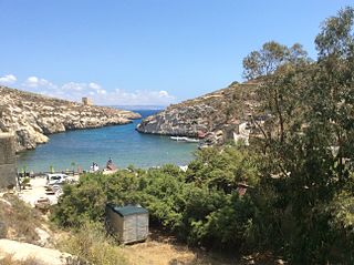
Mġarr ix-Xini, is a bay close to Għajnsielem (southwest), Xewkija and Sannat (southeast) on the Maltese island of Gozo. It lies in a gorge to the west of Mġarr Harbour, accessible mainly from the nearest village of Xewkija as well from Sannat.

The coastline of Malta consists of bays, sandy beaches, creeks, harbours, small villages, cities, cliffs, valleys, and other interesting sites. Here, there is a list of these different natural features that are found around the coast of Malta.

Gozo, known locally as Għawdex and in antiquity as Gaulos, is an island of the Maltese archipelago in the Mediterranean Sea. The island is part of Malta. After the island of Malta itself, it is the second-largest island in the archipelago. Compared to its southeastern neighbour, Gozo is more rural and known for its scenic hills, which are featured on its coat of arms.

The Gozo Museum of Archaeology is a museum in the Cittadella of Victoria in Gozo, Malta. The museum of was opened in 1960 as the first public museum in Gozo and was known as the Gozo Museum. The museum was redesigned and reopened in 1986 as the Archaeology Museum of Gozo. Today it is known as the Gozo Museum of Archaeology or the National Museum of Archaeology. The museum features archaeological artifacts and relics and displays covering the cultural history of the Island of Gozo from the prehistoric era to the early modern period. Its exhibits include the Maymūnah Stone.

In Malta most the main roads are in the outskirts of the localities to connect one urban area with another urban area. The most important roads are those that connect the south of the island with the northern part, like Tal-Barrani Road, Aldo Moro Street in Marsa and Birkirkara Bypass.

Gozo Region is one of five regions of Malta. The region includes the islands of Gozo, Comino and several little islets such as Cominotto. The region does not border with any other regions, but it is close to the Northern Region.

The Church of Saint John the Baptist, commonly known as the Rotunda of Xewkija or Xewkija Rotunda, is a Roman Catholic church in Xewkija, Gozo, Malta.

Santa Verna is a megalithic site in Xagħra on the island of Gozo, Malta. The site was originally occupied by a village and a megalithic temple. Although the temple is in poor condition now, in ancient times it was probably one of the major temples in the Maltese islands. The site takes its name from a chapel dedicated to Saint Venera that once stood close to the temple.

Qbajjar Bay is a small bay near Marsalforn, in the limits of Żebbuġ on the island of Gozo, Malta. It is located between Xwejni Bay to the west, and Marsalforn Bay to the east. The 18th century, Qolla l-Bajda Battery, one of the few surviving coastal fortifications in Gozo, is located between Qbajjar and Xwejni, on a promontory known as il-Ponta tat-Torri.

Għar Qawqla is a limestone formation located off Marsalforn on the island of Gozo in Malta. It was formerly a natural arch connected to the mainland, but the span collapsed at some point during the 20th century. It has been speculated that the name Marsalforn might be partially derived from forna, referring to the natural sea caves of the area, of which Għar Qawqla was one of the best-known.


