
Cannock Chase, often referred to locally as The Chase, is a mixed area of countryside in the county of Staffordshire, England. The area has been designated as the Cannock Chase Area of Outstanding Natural Beauty and is managed by Forestry England. The Chase gives its name to the Cannock Chase local government district. It is a former Royal forest.

Rugeley is a market town and civil parish in the Cannock Chase District, in Staffordshire, England. It lies on the north-eastern edge of Cannock Chase next to the River Trent; it is situated 8 miles (13 km) north of Lichfield, 10 miles (16 km) south-east of Stafford, 5 miles (8.0 km) north-east of Hednesford and 11 miles (18 km) south-west of Uttoxeter. At the 2021 Census, the population was 26,156.
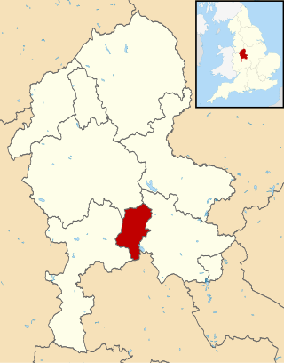
Cannock Chase is a local government district in Staffordshire, England. It is named after and covers a large part of Cannock Chase, a designated National Landscape. The council is based in the town of Cannock. The district also contains the towns of Hednesford and Rugeley, as well as a number of villages and surrounding rural areas.

Lichfield District is a local government district in Staffordshire, England. The district is named after its largest settlement, the city of Lichfield, which is where the district council is based. The district also contains the towns of Burntwood and Fazeley, along with numerous villages and surrounding rural areas, including part of Cannock Chase, a designated Area of Outstanding Natural Beauty.

Hednesford is a market town and civil parish in the Cannock Chase district of Staffordshire, England. The Cannock Chase area of natural beauty is to the north of the town. Hednesford is also 1 mile (1.6 km) to the north of Cannock and 5 miles (8.0 km) to the south of Rugeley. The population at the 2011 census was 17,343.

The Chase Line is a suburban railway line in the West Midlands region of England. It runs from its southern terminus, Birmingham International, to Walsall, and then Rugeley Trent Valley in Staffordshire, where it joins the Trent Valley line. The name of the line refers to Cannock Chase which it runs through at its northern end.
Brindley Heath is an area of heath land on Cannock Chase situated between Hednesford and Rugeley in the Cannock Chase District of Staffordshire, England. The area also forms a civil parish, which at the 2001 census, had a population of 862, decreasing to 827 at the 2011 Census.
Great Haywood is a village in central Staffordshire, England, just off the A51 and about 4.5 miles (7.2 km) northwest of Rugeley and 7.1 miles (11.4 km) southeast of the county town of Stafford. Population details taken at the 2011 census can be found under Colwich.
Milford is a village in the county of Staffordshire, England. It lies at the edge of Cannock Chase, on the A513 road between Stafford and Rugeley. Just to the north of the village is the River Sow.

Brocton is a village and civil parish in the English county of Staffordshire. It is within the borough of Stafford. The village describes itself as the Gateway to Cannock Chase, an Area of Outstanding Natural Beauty and a Site of Special Scientific Interest.

Beaudesert was an estate and stately home on the southern edge of Cannock Chase in Staffordshire. It was one of the family seats of the Paget family, the Marquesses of Anglesey. The estate was obtained by William Paget, 1st Baron Paget in 1546; the family's other main seat is at Plas Newydd.
The A460 is a main road in the Midlands of England. It runs from Wolverhampton in the West Midlands to Rugeley in Staffordshire. It is also a primary road linking Wolverhampton and Cannock with the M54, M6 and M6 Toll.
Hill Ridware is a small village in the civil parish of Mavesyn Ridware in the Lichfield District of Staffordshire, England. It is the largest settlement in the parish with a population of 857 at the 2011 Census. Situated across the River Trent from Rugeley, it is on the B5104 north of Armitage.
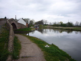
Colwich is a civil parish and village in Staffordshire, England. It is situated off the A51 road, about 3 miles (5 km) north-west of Rugeley and 7 miles (11 km) south-east of Stafford. It lies principally on the north-east bank of the River Trent, near Wolseley Bridge and just north of The Chase. The parish comprises about 2,862 hectares (28.62 km2) of land in the villages and hamlets of Colwich, Great Haywood, Little Haywood, Moreton, Bishton and Wolseley Bridge.
Hagley Park Academy was originally founded as Hagley Park County Secondary Modern in 1955 and was located in Rugeley, Staffordshire. Later it was rebuilt and changed its name to Hagley Park Sports College, becoming Hagley Park Academy between 2011 and 2015. This was a mixed secondary school which was part of the Creative Education Trust, along with Fair Oak Academy and Rugeley Sixth Form Academy.

Assheton Curzon, 1st Viscount Curzon, styled Lord Curzon between 1794 and 1802, was a British Tory politician.
Teddesley Hall was a large Georgian English country house located close to Penkridge in Staffordshire, now demolished. It was the main seat firstly of the Littleton Baronets and then of the Barons Hatherton. The site today retains considerable traces of the hall, gardens and other buildings, while the former home farm remains a working farm.
The Wolseley Centre is a visitor centre and nature reserve of the Staffordshire Wildlife Trust, in Staffordshire, England, about 2 miles (3 km) north-west of Rugeley, and about 7 miles (11 km) south-east of the county town of Stafford.

Rugeley Town Hall was a municipal building in the Market Square in Rugeley, Staffordshire, England. The building, which was the headquarters of Rugeley Urban District Council, was demolished in 1978.

St Augustine of Canterbury Church is the former parish church of the town of Rugeley in Cannock Chase District, Staffordshire, England. It is a grade II listed building parts of which date to the 12th century. In the early 19th century, it was replaced by St Augustine's Church across the road, and it is now partially ruined and known as "the Old Chancel".

