


Haidhausen (Central Bavarian: Haidhausn) is a quarter in Munich, Germany. It is now part of the borough of Au-Haidhausen.
Haidhausen (Central Bavarian: Haidhausn) is a quarter in Munich, Germany. It is now part of the borough of Au-Haidhausen.
Haidhausen is bordered to the north by Bogenhausen, Berg am Laim to the east, to the south by Au, and the west border of the district is delimited by the Isar river.
The boundary of the zone runs north along the Prinzregentenstraße avenue then west of the square Vogelweideplatz between the civic amenity site and the tram depot on the railway track which forms the eastern border, where the entire track is still part of Haidhausen. In the south the Rosenheimer, Hoch, Rabl and Balanstraße streets form the border with Au. To the west there are the right banks of the Isar river.
Haidhausen was first mentioned in the year 808 under the name of haidhusir described in the documents as a settlement of small houses and a church. From Munich you can reach it via the "gaachen Steig" (very steep path), which in the course of time became the term "Gasteig". The word also stands for the well-known cultural centre that marks the border to Haidhausen today. The salt trail led through Haidhausen to Munich. The production of clay bricks made from loamy soil was economically important at an early stage.
In the High Middle Ages Haidhausen belonged to the domain of the Counts of Wolfratshausen and after their extinction in 1157 to the Counts of Dießen, who renamed themselves von Andechs. Even before the death of the last Count Andechs, Otto III in 1248, the area passed to the Duchy of Bavaria of the Wittelsbach family in 1246 at the latest. From 1610 or 1612 Haidhausen as well as the neighbouring villages Au and Untergiesing belonged to the court ob der Au.
In Haidhausen was the country seat of the Counts of Preysing-Hohenaschau from the 17th century to 1827. Their castle later became church property and in its place the still existing monastery buildings were erected in Preysingstraße. Not far from today's Wiener Platz, small-town structures with hostels for poorer sections of the population had already developed at an early stage, who worked for example in the brick factories. The last of these houses can still be seen today, for example on the Kreppe.
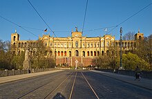
In 1835 there were already 10,000 people living in Haidhausen. Especially at the end of the 19th century, Haidhausen grew strongly as a result of industrialisation. At this time, the hospital Klinikum rechts der Isar was founded here and the Maximilianeum was built as the end point of Maximiliansstraße.
On 1 October 1854, the incorporation of Haidhausen together with Au and Giesing into the city of Munich took place after the inhabitants of the villages had declared their support almost unanimously in May 1848. After two years of construction, the Haidhaus railway station, built by Friedrich Bürklein, architect of the Maximilianeum, was opened in 1871. At that time the area "Auf den Lüften" between the railway station (east), Rosenheimer Straße (south), Milch- and Steinstraße (west), Preysingstraße (north) was still undeveloped. In 1870, Arnold von Zenetti designed a Wilhelminian style urban expansion plan for the "Streets to Braunau Railway Station" for the development of this area.
The semicircular Orleansplatz formed the basis for the symmetrical three-beam system of the Ostbahnhofviertel, which is also known as the "French Quarter" because of its streets named after French towns: Wörthstraße became the central axis – Weißenburger Straße and Belfortstraße the diagonal. In 1872 the first streets were laid out and named after places of victorious battles of the Franco-Prussian War of 1870/71. An exception is Bordeauxplatz, which was later named after the town partnership between Munich and Bordeaux. The area was built between 1870 and 1900 from Rosenheimer Strasse in a northerly direction—mainly in the style of the Neo-Renaissance of the 1880s and the New Baroque of the 1890s.
The development was carried out closely in order to provide affordable housing for the poorer population. Around 1900, one of the most densely populated areas in Munich developed, which today has a particularly high proportion (66%) of older buildings (before 1914).
The 1910 census revealed a population of over 60,000 in the Haidhausen area, and on 5 May 1919, after the Munich Räterepublik had been smashed up, the innkeepers of the Hofbräukeller were shot by members of the Freikorps, who had previously denounced the citizens of Perlach. On 16 October 1919 Adolf Hitler gave his first party political speech to 111 visitors in the Hofbräukeller. On the eve of the Hitler coup on 8 November 1923, Hitler proclaimed the 'National Revolution' in the Bürgerbräukeller on Rosenheimerstrasse.
For a long time, Haidhausen in Munich was regarded as a "shattered glass district" due to its poor conditions. When in the 1980s industrial areas were demolished and replaced by living space, the municipal Gallery Lothringer13 in Lothringerstr. 13, the Muffathalle and the Gasteig Cultural Centre were built, the old buildings were also gradually renovated. The attractiveness of the district gradually increased, so that today Haidhausen is counted among Munich's coveted residential areas, which are characterised by a multitude of shops, cafés, restaurants and a broad cultural offer.
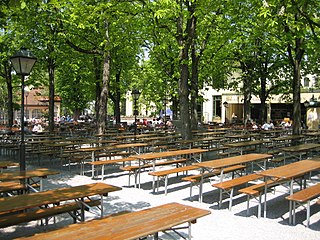
Due to its wide range of bars and restaurants, Haidhausen is considered the third centre of Munich's nightlife after the Glockenbachviertel and Schwabing. Beside inns and beer gardens there are restaurants of almost every state cuisine between Ostbahnhof, Rosenheimer Platz and Max-Weber-Platz.
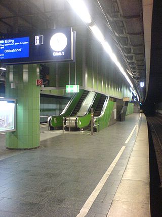
The Munich U-Bahn is an electric rail rapid transit network in Munich, Germany. The system began operation in 1971, and is operated by the municipally owned Münchner Verkehrsgesellschaft. The network is integrated into the Münchner Verkehrs- und Tarifverbund and interconnected with the Munich S-Bahn. The U-Bahn currently comprises eight lines, serving 96 stations, and encompassing 103.1 kilometres (64.1 mi) of routes.
The Bürgerbräukeller was a large beer hall in Munich, Germany. Opened in 1885, it was one of the largest beer halls of the Bürgerliches Brauhaus. After Bürgerliches merged with Löwenbräu in 1921, the hall was transferred to that company.

Munich East station is a railway station in Munich, the state capital of Bavaria, Germany. It opened as Haidhausen station in 1871 on the new Munich–Mühldorf and Munich–Rosenheim railway lines. The station is operated by DB Station&Service, a subsidiary of Deutsche Bahn AG. It is classified as a Category 1 station, one of 21 in Germany and two in Munich, the other being München Hauptbahnhof. It is the city's third interregional station besides München Hauptbahnhof in the city centre and München-Pasing in the west.

Altstadt and Lehel are districts of the German city of Munich. Together they form the first borough of the city: Altstadt-Lehel.

Au-Haidhausen is the 5th borough of the German city of Munich, Bavaria. It is formed by the Au and Haidhausen districts.

Au is a district in the south eastern plain tract of the German city of Munich in Bavaria. Au extends from the Deutsches Museum in the north and along the Isar up to Wittelsbacherbrücke in the south.

This article gives an overview about the architecture of Munich, Germany.

The Maximilianstraße in Munich is one of the city's four royal avenues next to the Brienner Straße, the Ludwigstraße and the Prinzregentenstraße. It starts at Max-Joseph-Platz, where the Residenz and the National Theatre are situated, and runs east-west. Planned and begun in 1850 by King Maximilian II of Bavaria, the street takes his name. The lead architect was Friedrich Bürklein. Today, Maximilianstraße has the distinction of the highest retail rents in Germany.
Munich Isartor station is a station opened in 1972 on the Munich S-Bahn on the trunk line between Munich Central Station and Munich East station (Ostbahnhof). It is located below Isartorplatz and the Thierschstraße/Zweibrückenstraße intersection in Munich and is named after the nearby Isartor city gate. It is classified by Deutsche Bahn as a category 4 station.

Munich Rosenheimer Platz station is one five underground station opened in 1972 on the trunk line of the Munich S-Bahn between Munich Central Station and Munich East station. It is under the street of the same name and Rosenheimerstraße in the Munich district of Haidhausen. It has two platform tracks and is classified by Deutsche Bahn as a category 4 station.

The Ostfriedhof is a cemetery in Munich, situated in the district of Obergiesing, established in 1821 and still in use. It contains an area of more than 30 hectares and approximately 34,700 burial plots.
Nockherberg is the name of a small terrace on the slope of the eastern bank of the Isar in Munich, situated in the urban district of Au. An annual beer festival rich in tradition takes place there in the Paulaner Brewery - the Salvator-Ausschank auf dem Nockherberg The name of the raised terrace is often used synonymously for this festival or its opening event, the tapping of the first barrel of a strong, seasonal beer (Starkbieranstich).
The Balanstraße is a street in Munich which begins at the Rosenheimer Platz and runs in a southerly direction through the districts Haidhausen, Giesing and Ramersdorf to the district of Fasangarten. It ends at the border road directly on the city boundary to the municipality Neubiberg in the district of Munich.

The following outline is provided as an overview of and topical guide to Munich:

Denning is a quarter of the Bavarian capital Munich that belongs to district 13 Bogenhausen.

The Munich Old Town is part of the Bavarian capital Munich and has belonged to the city the longest, even if some places which are meanwhile districts of Munich, were mentioned long before Munich's documents spoke of the Old Town. The Old Town forms together with the district Lehel, the municipality No. 1 Altstadt-Lehel. The entire area of the Old Town is listed as both a historical ensemble as well as a historical monument listed in the Bavarian historical monument list.

The Ismaninger Straße is a city center, entrance and exit road in Munich.

Englschalking is a quarter of the Bavarian capital Munich and belongs to the district 13 Bogenhausen.

Weißenburger Platz is a square in Munich's Franzosenviertel in the Haidhausen district. In the middle of the concentrically arranged square is the Glaspalast-Brunnen, designed by August von Voit in 1853. This was initially located in the Glaspalast in the Alter Botanischer Garten - hence the name. At the end of the 19th century the fountain was moved to Orleansplatz. When the Ostbahnhof there was rebuilt, the Glaspalast-Brunnen had to make room and was moved to the nearby Weißenburger Platz. After dusk the fountains water feature is illuminated.
This article includes a list of references, related reading, or external links, but its sources remain unclear because it lacks inline citations .(June 2024) |
48°07′56″N11°35′52″E / 48.1322°N 11.5978°E
| International | |
|---|---|
| National | |