Hailes Castle, Gloucestershire

Last updated
The ruins of Hailes Abbey now occupy the former castle site Hailes Abbey.jpg
The ruins of Hailes Abbey now occupy the former castle site

Hailes Castle was a castle in the village of Hailes in Gloucestershire, England.

Contents

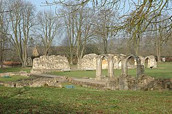
The castle was built around the 11th or early 12th century near the church in the village. [1] The castle was moated, although this has since been filled in. [1] The castle was strengthened by Ralph of Worcester at the start of the difficult years of the Anarchy, with Hailes Castle playing a role in the conflict between 1139 and 1145. [2] The castle was probably demolished in the 1240s to make way for the construction of Hailes Abbey. [1]

See also

Related Research Articles

Gloucestershire County of England

Gloucestershire is a county in South West England. The county comprises part of the Cotswold Hills, part of the flat fertile valley of the River Severn, and the entire Forest of Dean.

Oxfordshire County of England

Oxfordshire is a landlocked county in the far west of the government statistical region of South East England. The ceremonial county borders Warwickshire to the north-west, Northamptonshire to the north-east, Buckinghamshire to the east, Berkshire to the south, Wiltshire to the south-west and Gloucestershire to the west.

Offas Dyke Path Footpath in Wales and England

Offa's Dyke Path is a long-distance footpath broadly following the Wales–England border. Officially opened on 10 July 1971, by Lord Hunt, it is one of Britain's National Trails and draws walkers from throughout the world. About 60 miles (97 km) of the 177-mile (285 km) route either follows, or keeps close company with, the remnants of Offa's Dyke, an earthwork, most of which was probably constructed in the late 8th century on the orders of King Offa of Mercia.

Cotswold Way

The Cotswold Way is a 102-mile (164 km) long-distance footpath, running along the Cotswold Edge escarpment of the Cotswold Hills in England. It was officially inaugurated as a National Trail on 24 May 2007 and several new rights of way have been created.

Hawkesbury, Gloucestershire

Hawkesbury is a hamlet consisting of a few cottages around a triangular green. It is also the name of a civil parish in the South Gloucestershire unitary authority in England in which Hawkesbury itself lies, it is located west of Hawkesbury Upton, off the A46 road.

Benington Castle

Benington Castle is a ruined castle in the village of Benington, near Stevenage in Hertfordshire, England at grid reference TL296236. It has been protected since 1936 as a scheduled ancient monument.

Gloucester Castle

Gloucester Castle was a Norman-era royal castle situated in the city of Gloucester in Gloucestershire, England. It was demolished in 1787 and replaced by Gloucester Prison.

Toddington, Gloucestershire Human settlement in England

Toddington is a village and civil parish in north Gloucestershire in Tewkesbury Borough, located approximately 12 miles (20 km) north-east of Cheltenham with a population of around 300, increasing to 419 at the 2011 census

The Oxfordshire Way is a long-distance walk in Oxfordshire, England, with 6 miles in Gloucestershire and very short sections in Buckinghamshire. The path links with the Heart of England Way and the Thames Path.

Miserden Human settlement in England

Miserden is a village and civil parish in Stroud District, Gloucestershire, England, 4 miles north east of Stroud. The parish includes Whiteway Colony and the hamlets of Sudgrove and The Camp. In the 2001 census the parish had a population of 420, increasing to 449 at the 2011 census.

Nympsfield Long Barrow Barrow remains in England

Nympsfield Long Barrow is the remains of a Neolithic burial site or barrow, located close to the village of Nympsfield in Gloucestershire, South West England.

Bledisloe Tump was a castle in the village of Awre in Gloucestershire, England.

Castle Tump, Dymock

Castle Tump was a castle in the village of Dymock in Gloucestershire, England.

Cirencester Castle

Cirencester Castle was a castle in the town of Cirencester in Gloucestershire, England.

Stow Green Castle, also known as Castle Tump, was a castle near the village of St Briavels in Gloucestershire, England.

Littledean Camp was originally a castle overlooking the village of Littledean in Gloucestershire, England, notable for its unique early Norman design.

Winchcombe Castle was a castle in the town of Winchcombe in Gloucestershire, England.

South Cerney Castle was an adulterine castle of Motte and bailey construction built in South Cerney, Gloucestershire in the mid-12th century. Today only slight earthwork remains and they are a scheduled monument.

St Brides Major (community) Human settlement in Wales

St Brides Major is a community on the western edge of the Vale of Glamorgan, South Wales. Its largest settlement is the village of St Brides Major, and also includes the villages of Ogmore-by-Sea and Southerndown, and the hamlets of Ogmore Village, Castle-upon-Alun, Heol-y-Mynydd, Norton and Pont-yr-Brown It is notable for coastal geology and scenery, limestone downlands and fossilised primitive mammals, sea cliffs and beaches, two Iron Age hillforts, three medieval castle sites,, two stepping stone river crossings and a clapper bridge. Three long distance paths cross the community. It is the western limit of the Vale of Glamorgan Heritage Coast, and has a visitor centre and tourist facilities.

References

  1. 1 2 3 National Monuments Website, accessed 19 December 2010.
  2. Walker, p.15; National Monuments Website, accessed 19 December 2010.

Bibliography

Coordinates: 51°58′11″N1°55′35″W / 51.96972°N 1.92639°W / 51.96972; -1.92639