
Marion County is a county located in the North Central region of the U.S. state of Florida. As of the 2020 census, the population was 375,908. Its county seat is Ocala.
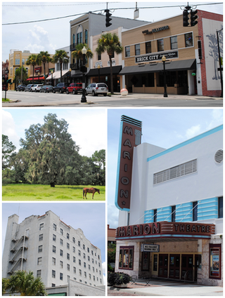
Ocala is a city in and the county seat of Marion County, Florida, United States. Located in North Central Florida, the city's population was 63,591 as of the 2020 census, up from 56,315 at the 2010 census and making it the 43rd-most populated city in Florida. Ocala is the principal city of the Ocala metropolitan area, which had a population of 375,908 in 2020.

The Ocala National Forest is the second largest nationally protected forest in the U.S. State of Florida. It covers 607 square miles (1,570 km2) of North Central Florida. It is located three miles (5 km) east of Ocala and 16 miles (26 km) southeast of Gainesville. The Ocala National Forest, established in 1908, is the oldest national forest east of the Mississippi River and the southernmost national forest in the continental U.S. The word Ocala is thought to be a derivative of a Timucuan term meaning "fair land" or "big hammock". The forest is headquartered in Tallahassee, as are all three National Forests in Florida, but there are local ranger district offices located in Silver Springs and Umatilla.

The Apalachicola National Forest is the largest U.S. National Forest in the state of Florida. It encompasses 632,890 acres and is the only national forest located in the Florida Panhandle. The National Forest provides water and land-based outdoors activities such as off-road biking, hiking, swimming, boating, hunting, fishing, horse-back riding, and off-road ATV usage.

Lake Istokpoga is a 26,762.9-acre (108.306 km2) freshwater lake in Highlands County, Florida. It is fed by two creeks, Arbuckle Creek and Josephine Creek. The oblong-shaped lake is approximately 5 miles (8.0 km) wide by 10 miles (16 km) long. It is considered the fifth largest lake in the state of Florida. Despite its area, it is very shallow, with an average depth of only 4 feet (1.2 m). Maximum depth is 10 feet (3.0 m). As a result, boaters must be cautious to not become stranded in muck near the shore line. Bass and pontoon boats are the most commonly used watercraft, with some use of airboats. With such shallowness, this lake is extremely dangerous for boaters during windstorms, as the waves get quite high.
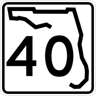
State Road 40 is a 91.8-mile-long (147.7 km) east–west highway across northern and east-central Florida, running from U.S. Highway 41 (US 41) in Rainbow Lakes Estates eastward through Ocala over the Ocklawaha River and through the heart of the Ocala National Forest to SR A1A in Ormond Beach. Names of the road include Silver Springs Boulevard in Ocala, Fort Brooks Road from Silver Springs through Astor, Butler Road in Astor, and Granada Boulevard in Ormond Beach. Former sections in Ormond Beach are named "Old Tomoka Road" and "Old Tomoka Avenue."

The Florida Trail is one of eleven National Scenic Trails in the United States, created by the National Trails System Act of 1968. It runs 1,500 miles (2,400 km), from Big Cypress National Preserve to Fort Pickens at Gulf Islands National Seashore, Pensacola Beach. Also known as the Florida National Scenic Trail, the trail provides permanent non-motorized recreation for hiking and other compatible activities within an hour of most floridians.

Salt Springs is an unincorporated community in Marion County, Florida, United States. It is located near Lake George. The community is part of the Ocala Metropolitan Statistical Area. Salt Springs is seated among the Ocala National Forest.

The Mount Massive Wilderness is a federally designated wilderness area in the Sawatch Range, located in the U.S. state of Colorado. It is operated jointly by the United States Forest Service and the Fish and Wildlife Service as part of the San Isabel National Forest and the Leadville National Fish Hatchery. It is 30,540 acres (123.6 km2) in size, with 27,980 acres (113.2 km2) in San Isabel National Forest and 2,560 acres (10.4 km2) in Leadville National Fish Hatchery, and it was designated by the US Congress in 1980. The name comes from Mount Massive, the second highest peak in Colorado, located inside the wilderness. Elevations in the wilderness range from 9,700 feet (3,000 m) to 14,421 feet (4,396 m). It is the only federally designated wilderness area within the National Fish Hatchery System.

Juniper Springs, located in the Ocala National Forest east of Ocala, Florida, is a natural spring that forms the headwaters of Juniper Creek that winds its way to Lake George in the Saint Johns River. It is one of the oldest and best known recreation areas.

State Road 19 is a Florida State Road in Putnam, Marion, and Lake counties. It runs from Groveland to Palatka through Ocala National Forest. Along with SR 33, SR 19 provides a mostly rural north-south corridor through central Florida from Lakeland to Palatka.

The Seminole State Forest is in the U.S. state of Florida. The 25,812-acre (10,446 ha) forest is located in Central Florida, near Eustis. Access to the forest is available from Florida State Road 44, Lake County Road 46A and Florida State Road 46. Surrounding parks and preserved areas include Lower Wekiva River Preserve State Park, Rock Springs Run State Reserve, Lake Norris Conservation Area, and the Ocala National Forest. The Florida National Scenic Trail runs through the from southeast to northwest.

WMFV is a radio station in Ocala, Florida, broadcasting a public radio format as a member of National Public Radio (NPR). Licensed to the unincorporated suburb of Cedar Creek, the station is currently owned by Community Communications of Orlando as a semi-satellite of Central Florida's main NPR station, WMFE-FM (90.7) and is operated out of WMFE-FM's studios in Orlando. In addition to Ocala, WMFV serves The Villages, an age-restricted master planned development. This arrangement is similar to a commercial station in Orlando, as Fox's O&O television station WOFL has Ocala-based WOGX also serve as a semi-satellite station.

Lake Glenada is a natural lake in Highlands County, Florida, south of the city of Avon Park, Florida. It has an irregular shape and has a surface area of 197 acres (0.80 km2). It is roughly 0.75 miles (1.21 km) long and about a 0.5 miles (0.80 km) wide. Its deepest part is about 35 feet (11 m). A bathymetric map produced by Florida Lakewatch shows it actually has three sections, one 35 feet (11 m) deep, another 25 feet (7.6 m) deep and still another 15 feet (4.6 m) deep.
Pioneer Lake is a round natural freshwater lake in northern Highlands County, Florida. Just to the south is Lake Viola (see Lake Viola and to the north is Lake Pythias. Pioneer Lake has a surface area of 93 acres and a maximum depth of 30 feet. It is found at an elevation of 98 feet.

Florida Lakewatch, established in 1986, is a volunteer water-monitoring program coordinated through the University of Florida. This project is headquartered at Gainesville, Florida, within the campus of the University of Florida. Florida Lakewatch has in its history obtained funding from a number of sources, but currently is mostly funded by the state of Florida.

Clearwater Lake Recreation Area and the Clearwater Lake Campground are located by Clearwater Lake along the southeastern edge of the Ocala National Forest in Central Florida outside Paisley, Florida in Lake County, Florida. The recreation area has 42 campsites, a picnic area, and a beach in an area of oak hammock at 24511 County Road 42. The lake covers 32 acres (13 ha). The recreation area has access to hiking and biking trails. Canoe rentals are offered. There is also a nature trail by the lake, mountain biking on the Paisley Woods Bicycle Trail, and access to the Florida Trail. The area is also used by kayakers.
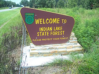
The Indian Lake State Forest is approximately 4,466 acres of gently rolling sandhills and pastures just north of historic Silver Springs in Marion County, Florida. This property was acquired in 2007 and 2008 under the Florida Forever program, with additional money from Marion County and help from The Nature Conservancy, Silver Springs Working Group, and the Department of Environmental Protection.
Hickorynut Lake, also known sometimes as Little Hickorynut, is a natural freshwater lake on the northwest side of Walt Disney World, in Orange County, Florida. This lake has an irregular shape and much of it is surrounded by land that floods easily. On the east side of the lake is Florida State Road 429, a toll highway. Some residential areas are now bordering it.


