
Bavaria, officially the Free State of Bavaria, is a state in the southeast of Germany. With an area of 70,550.19 km2 (27,239.58 sq mi), it is the largest German state by land area, comprising roughly a fifth of the total land area of Germany, and with over 13.08 million inhabitants, it is the second most populous German state, behind only North Rhine-Westphalia; however, due to its large land area, its population density is below the German average. Major cities include Munich, Nuremberg, and Augsburg.

Lower Bavaria is one of the seven administrative regions of Bavaria, Germany, located in the east of the state. It consists of nine districts and 258 municipalities.
Altötting is a Landkreis (district) in Bavaria, Germany. It is bounded by Austria and the Bavarian districts of Traunstein, Mühldorf and Rottal-Inn.

The Inn is a river in Switzerland, Austria and Germany. The 518 km (322 mi) long river is a right tributary of the Danube, being the third largest tributary of the Danube by discharge. The highest point of its drainage basin is the summit of Piz Bernina at 4,049 m (13,284 ft). The Engadine, the valley of the En, is the only Swiss valley whose waters end up in the Black Sea.

The Bavarian Alps is a collective name for several mountain ranges of the Northern Limestone Alps within the German state of Bavaria.

Bavarians are an ethnographic group of Germans of the Bavaria region, a state within Germany. The group's dialect or speech is known as the Bavarian language, native to Altbayern, roughly the territory of the Electorate of Bavaria in the 17th century.
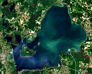
Chiemsee is a freshwater lake in Bavaria, Germany, near Rosenheim. It is often called "the Bavarian Sea". The rivers Tiroler Achen and Prien flow into the lake from the south, and the river Alz flows out towards the north. The Alz flows into the Inn which then merges with the Danube. The Chiemsee is divided into the bigger, north section, in the northeast, called Weitsee, and the Inselsee, in the southwest.

The Duchy of Bavaria was a frontier region in the southeastern part of the Merovingian kingdom from the sixth through the eighth century. It was settled by Bavarian tribes and ruled by dukes (duces) under Frankish overlordship. A new duchy was created from this area during the decline of the Carolingian Empire in the late ninth century. It became one of the stem duchies of the East Frankish realm, which evolved as the Kingdom of Germany and the Holy Roman Empire.
Traun is a city in Austria.

The Kingdom of Bavaria was a German state that succeeded the former Electorate of Bavaria in 1806 and continued to exist until 1918. With the unification of Germany into the German Empire in 1871, the kingdom became a federated state of the new empire and was second in size, power, and wealth only to the leading state, the Kingdom of Prussia.
Trostberg is a town in the district of Traunstein, in Bavaria, Germany. It is situated on the river Alz, 19 km northwest of Traunstein. As with other 'old towns' in the region, it is a popular local tourist spot.
Burgkirchen an der Alz is a municipality in the district of Altötting, in Bavaria, Germany. It is situated on the river Alz, 8 km west of Burghausen.

Chiemgau is the common name of a geographic area in Upper Bavaria. It refers to the foothills of the Alps between the rivers Inn and Traun, with the Chiemsee at its center. The political districts that contain the Chiemgau are Rosenheim and Traunstein. Wendelstein is the name of a famous mountain close by but not strictly in the Chiemgau.
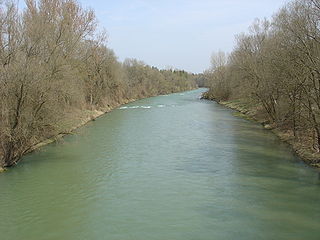
The Alz is a river in Bavaria, southern Germany, the only discharge of the Chiemsee. Its origin is on the northern shore near Seebruck. It is a right tributary of the Inn, into which it flows in Marktl. Other towns on the Alz are Altenmarkt an der Alz, Trostberg, Garching an der Alz and Burgkirchen an der Alz.

Seeon-Seebruck is a municipality in the district of Traunstein in southern Bavaria in Germany.

Emmerting is a municipality in the district of Altötting in Bavaria in Germany and member of the administrative association of the same name.
The Bavarian ice hockey leagues are part of the German ice hockey league system and form the tiers four to six of the league system in the state of Bavaria. The leagues are operated by the Bayrischer Eissport Verband, the Bavarian association for ice sports.

The Traun is a river in Upper Bavaria, Germany. The nearly 29 kilometer long river is formed by the confluence of the Weiße Traun and the Rote Traun near Siegsdorf. It passes through Traunstein and Traunreut, and flows into the Alz near Altenmarkt an der Alz.
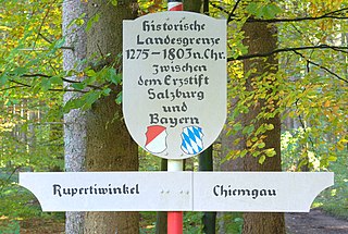
The Rupertiwinkel is a small historic region on the southeastern border of Bavaria, Germany. Part of the Archbishopric of Salzburg until the early 19th century, it is named after the first Salzburg bishop Saint Rupert (c.660–710), apostle to the Duchy of Bavaria.
