Related Research Articles
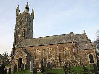
Kingsbridge is a market town and tourist hub in the South Hams district of Devon, England, with a population of 6,116 at the 2011 census. Two electoral wards bear the name of Kingsbridge. Their combined population at the above census was 4,381. It is situated at the northern end of the Kingsbridge Estuary, a ria that extends to the sea six miles south of the town. It is the third largest settlement in the South Hams and is 17 miles (27 km) southwest of Torquay and 17 miles (27 km) southeast of Plymouth.

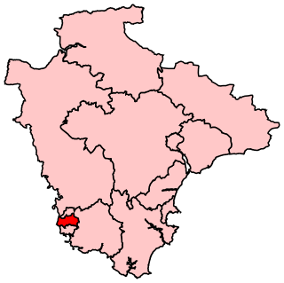
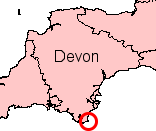
South Hams is a local government district on the south coast of Devon, England. Its council is based in the town of Totnes, although the largest town is Ivybridge. The district also contains the towns of Dartmouth, Kingsbridge and Salcombe and numerous villages and surrounding rural areas.
Okehampton is a town and civil parish in West Devon in the English county of Devon. It is situated at the northern edge of Dartmoor, and had a population of 5,922 at the 2011 census. Two electoral wards are based in the town. Their joint population at the same census was 7,500.
Ivybridge is a town and civil parish in the South Hams, in Devon, England. It lies about thirteen miles east of Plymouth. It is at the southern extremity of Dartmoor, a National Park of England and Wales and lies along the A38 "Devon Expressway" road. There are two electoral wards in Ivybridge East and Ivybridge West with a total population of 11,851.
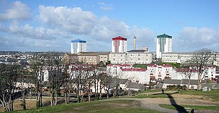
Devonport, formerly named Plymouth Dock or just Dock, is a district of Plymouth in the English county of Devon, although it was, at one time, the more important settlement. It became a county borough in 1889. Devonport was originally one of the "Three Towns" ; these merged in 1914 to form what would become in 1928 the City of Plymouth. It is represented in the Parliament of the United Kingdom as part of the Plymouth Sutton and Devonport constituency. Its elected Member of Parliament (MP) is Luke Pollard, who is a member of the Labour Party. The population of the ward at the 2011 census was 14,788.

West Devon is a local government district with borough status in Devon, England. Its council is based in Tavistock, the borough's largest town. The borough also includes the towns of Hatherleigh, North Tawton and Okehampton, along with numerous villages and surrounding rural areas.

Plymstock is a commuter suburb of Plymouth and former civil parish in the English county of Devon.

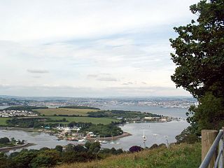
The Erme is a river in south Devon, England. From its source on Dartmoor it flows in a generally southerly direction past some of the best-preserved archaeological remains on the moor. It leaves the moor at the town of Ivybridge and continues southward, passing the settlements of Ermington, Modbury and Holbeton. Near Holbeton it becomes a ria and empties into the English Channel in Bigbury Bay, between the rivers Yealm and Avon.

South West Devon is a constituency represented in the House of Commons of the UK Parliament since 1997 by Sir Gary Streeter, a Conservative.
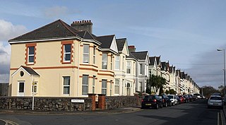
Peverell is a neighbourhood of Plymouth in the English county of Devon. The 2001 Census estimated the population as 6,455, increasing dramatically to 13,553 at the 2011 census.

Wembury is a village on the south coast of Devon, England, very close to Plymouth Sound. Wembury is located south of Plymouth. Wembury is also the name of the peninsula in which the village is situated. The village lies in the administrative district of the South Hams within the South Devon Area of Outstanding Natural Beauty (AONB). The South West Coast Path goes past the coastal end of the town. The National Trust has taken an active role in maintaining the scenic and historic characteristics of the village and its surrounding area
Bickleigh is a small village on the southern edge of Dartmoor in Devon, England. It has a population of about 50 people. It is in the South Hams district, and is about 7 miles (11 km) north of Plymouth city centre. The village is part of the electoral ward called Bickleigh and Shaugh. At the 2011 census the ward population was 4,723. 42 Commando is currently based at Bickleigh Barracks.
Plymouth Moor View is a constituency represented in the House of Commons of the Parliament of the United Kingdom. It elects one Member of Parliament (MP) by the first past the post system of election and has been represented since 2015 by Johnny Mercer of the Conservative Party.
Weston Mill is a district in the ward of Ham, which is part of the City of Plymouth, Devon, England. It consists of two parts Weston Mill Village which was first mentioned in the Domesday Book in 1155 and the other part which dates to the Victorian period, they are separated by Weston Mill Hill, which is the only street with this name. It shares its borders with Ham Woods Nature Reserve, King's Tamerton, St. Budeaux and Camels Head. The area derived its name from being the mill belonging to the tithing, Geoffrey de Weston. It is situated close to the major naval base Devonport Dockyard, and the majority of the housing in the area is privately owned. The A3064 'St. Budeaux Bypass' also runs through the area. Together with King's Tamerton the area's population in the 2001 census, was 4,647, of which 50.2 per cent were male and 49.8 per cent were female.

Newton Ferrers is a village and former manor, civil and ecclesiastical parish, now in the parish of Newton and Noss, in the South Hams district, in the county of Devon, England. It is situated on a creek of the River Yealm estuary, about 6 miles (10 km) south-east of the City of Plymouth. It lies within the South Devon Area of Outstanding Natural Beauty. According to the United Kingdom Census 2011 the population of the village of Newton Ferrers was 1,268 and that of the electoral ward of Newton and Noss was 1,814.
Burrator is a grouped parish council in the English county of Devon. It is entirely within the boundaries of the Dartmoor National Park and was formed in 1973 as a result of the Local Government Act 1972 from the older councils of Meavy, Sheepstor and Walkhampton.
Stokenham is a village and civil parish in the English county of Devon. The population of the parish at the 2011 census was 1,895.
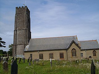
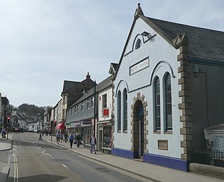
Stoke Fleming is a village and civil parish in the South Hams district of Devon, England. It lies on the A379 road about one and a half miles south of the town of Dartmouth, at the north end of Start Bay and within the South Devon Area of Outstanding Natural Beauty. In 2001 the parish had a population of 1,012, compared to 708 in 1901, reducing again to 803 at the 2011 census The parish is a major part of the Skerries electoral ward. The ward's total population at the same census was 1,927. Stoke Fleming has a pub called The Green Dragon, a primary school, library and a football club.
References
- ↑ "Plymouth ward population 2011". Archived from the original on 11 April 2015. Retrieved 5 April 2015.
- ↑ Gover, J. E. B.; Mawer, A.; Stenton, F. M. (1931–32). The Place-names of Devon. English Place-Name Society, 8-9. Vol. 1. Cambridge: Cambridge University Press. pp. 20, 246.
50°23′47″N4°09′48″W / 50.39639°N 4.16333°W
| | This Devon location article is a stub. You can help Wikipedia by expanding it. |