Hamble Rail Trail

Last updated

The start of the trail Start of the Hamble Rail Trail - geograph.org.uk - 1463975.jpg
The start of the trail

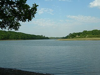
The Hamble Rail Trail is a 4.5-mile-long (7.2 km) circular footpath in Hampshire, southern England, comprising a path which runs alongside a disused railway track that connects Hamble-le-Rice to Royal Victoria Country Park and looping back via a section of the Solent Way footpath. [1]

Long-distance trail long trail used for walking, backpacking, cycling, horse riding or cross-country skiing

A long-distance trail is a longer recreational trail mainly through rural areas used for hiking, backpacking, cycling, horse riding or cross-country skiing. They exist on all continents except Antartica.

Hampshire County of England

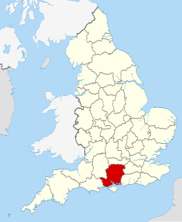
Hampshire is a county on the southern coast of England. The county town is the city of Winchester. Its two largest cities, Southampton and Portsmouth, are administered separately as unitary authorities; the rest of the county is governed by Hampshire County Council.

England Country in north-west Europe, part of the United Kingdom

England is a country that is part of the United Kingdom. It shares land borders with Wales to the west and Scotland to the north-northwest. The Irish Sea lies west of England and the Celtic Sea lies to the southwest. England is separated from continental Europe by the North Sea to the east and the English Channel to the south. The country covers five-eighths of the island of Great Britain, which lies in the North Atlantic, and includes over 100 smaller islands, such as the Isles of Scilly and the Isle of Wight.

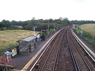
The railway track in question was constructed during the First World War to transport aircraft from Manchester to Hamble-le-Rice. [1] A siding was built as part of the railway to serve the flying boat factory in Hamble. The line was not actually used during the war as hostilities ceased before it could be utilised; it was, however, purchased for the storage and transportation of oil to the BP oil terminal in Hamble. [1] BP maintain the option of reopening the line, but it has not been used since 1986 when it transported crude oil from Wytch Farm in Dorset, a route which has since been replaced by a 56-mile-long (90 km) pipeline. [1]

World War I 1914–1918 global war originating in Europe

World War I, also known as the First World War or the Great War, was a global war originating in Europe that lasted from 28 July 1914 to 11 November 1918. Contemporaneously described as "the war to end all wars", it led to the mobilisation of more than 70 million military personnel, including 60 million Europeans, making it one of the largest wars in history. It is also one of the deadliest conflicts in history, with an estimated nine million combatants and seven million civilian deaths as a direct result of the war, while resulting genocides and the 1918 influenza pandemic caused another 50 to 100 million deaths worldwide.

Manchester City and metropolitan borough in England

Manchester is a city and metropolitan borough in Greater Manchester, England, with a population of 545,500 as of 2017. It lies within the United Kingdom's second-most populous built-up area, with a population of 3.2 million. It is fringed by the Cheshire Plain to the south, the Pennines to the north and east, and an arc of towns with which it forms a continuous conurbation. The local authority is Manchester City Council.

BP British multinational oil and gas company

BP plc is a British multinational oil and gas company headquartered in London, United Kingdom. It is one of the world's seven oil and gas "supermajors", whose performance in 2012 made it the world's sixth-largest oil and gas company, the sixth-largest energy company by market capitalization and the company with the world's 12th-largest revenue (turnover). It is a vertically integrated company operating in all areas of the oil and gas industry, including exploration and production, refining, distribution and marketing, petrochemicals, power generation and trading. It also has renewable energy interests in biofuels and wind power.

Related Research Articles

River Hamble river in Hampshire, England

The River Hamble is a river in Hampshire, England. It rises near Bishop's Waltham and flows for some 7.5 miles (12 km) through Botley, Bursledon, and Swanwick before entering Southampton Water near Hamble-le-Rice and Warsash.

Hamble-le-Rice village in the United Kingdom

Hamble-le-Rice is a village and civil parish in the Borough of Eastleigh in Hampshire, UK. It is best known for being an aircraft training centre during the Second World War and is a popular yachting location. The village and the River Hamble also featured in the 1980s BBC television series Howards' Way. The village centre, known as The Square, Hamble, has a more traditional English village aesthetic which differentiates it from the small industrial areas close-by the village.

Weardale Railway

The Weardale Railway is an independently owned British single-track branch line heritage railway between Bishop Auckland, Witton-le-Wear, Wolsingham, Frosterley and Stanhope. Weardale Railway began services on 23 May 2010, but decided to run special trains rather than a scheduled service for the 2013 season.

Rail trail railroad bed converted to a recreational trail

A rail trail is the conversion of a disused railway track into a multi-use path, typically for walking, cycling and sometimes horse riding and snowmobiling. The characteristics of abandoned railways—flat, long, frequently running through historical areas—are appealing for various developments. The term sometimes also covers trails running alongside working railways; these are called "rails with trails". Some shared trails are segregated, with the segregation achieved with or without separation. Many rail trails are long-distance trails.

Tissington Trail

The Tissington Trail is a bridleway, footpath and cycleway in Derbyshire, England, along part of the trackbed of the former railway line connecting Ashbourne to Buxton. It takes its name from the village of Tissington, which it skirts. Opened in 1971, and now a part of the National Cycle Network, it stretches for 13 miles (21 km) from Parsley Hay (53.1706°N 1.7828°W) in the north to Ashbourne (53.0196°N 1.7397°W) in the south.

Matlock railway station

Matlock Railway Station is a railway station owned by Network Rail and managed by East Midlands Trains in the town of Matlock, Derbyshire, England. The station is the terminus of both the Derwent Valley Line from Derby and Peak Rail who operate heritage services to Rowsley South. Both lines are formed from portions of the Midland Railway's former main line to Manchester. Through running is technically possible but is not done in normal service.

Solent Way

The Solent Way is a 60-mile (97 km) long-distance footpath in Hampshire, southern England. With the exception of a few inland diversions, the path follows the coast of the Solent, the sea strait that separates the mainland England from the Isle of Wight. The Solent Way forms part of the E9 European Coastal Path, which runs for 5000 km (3125 miles) from Cape St Vincent in Portugal to Narva-Jõesuu in Estonia.

Strawberry Trail

The Strawberry Trail is a 15-mile footpath through Hampshire, England

Hamble railway station railway station

Hamble railway station is an unstaffed station near the village of Hamble-le-Rice, England. It is served by a 2-track electrified line which joins the Southampton to London main line, in the direction of Southampton at St Denys in Southampton, and joins the line running east from Eastleigh at Fareham.

Camel Trail

The Camel Trail is a permissive cycleway in Cornwall, England, United Kingdom, that provides a recreational route for walkers, cyclists and horse riders. The trail is flat ; running from Padstow to Wenford Bridge via Wadebridge and Bodmin, it is 17.3 miles (27.8 km) long and used by an estimated 400,000 users each year generating an income of approximately £3 million a year.

Formartine and Buchan Way

The Formartine and Buchan Way is a long-distance footpath in Scotland, extending from Dyce north to Peterhead and Fraserburgh in the Buchan and Formartine districts of Aberdeenshire in Scotland. It follows the track of a former railway line, the Formartine and Buchan Railway, and is open to walkers, cyclists and horse riders. The railway closed in 1979 (Fraserburgh) and 1970 (Maud-Peterhead). The walkway opened in the early 1990s, and is managed by Aberdeenshire Council. It is listed as one of Scotland's Great Trails by Scottish Natural Heritage. Places of interest along the way include Drinnes Wood Observatory, Strichen Stone Circle, Aden Country Park, Deer Abbey and The White Horse at Strichen.

Hundred of Hoo Railway

The Hundred of Hoo Railway is a railway line in Kent, England, following the North Kent Line from Gravesend before diverging at Hoo Junction near Shorne Marshes and continuing in an easterly direction across the Hoo Peninsula, passing near the villages of Cooling, High Halstow, Cliffe and Stoke before reaching the Isle of Grain and the container port on its eastern tip, Thamesport. There used to be a short branch line leading from Stoke Junction to the coastal town of Allhallows but this closed from 4 December 1961, the same date on which the Hundred of Hoo line was closed to passenger services.

The Staines & West Drayton Railway (S&WDR) is a former railway on the western edge of London, England. It was about 5 12 miles (9 km) long and ran roughly north-south along the River Colne, parallel to the modern M25 motorway west of Heathrow Airport. It opened from West Drayton on the Great Western Main Line to Colnbrook in 1884 and reached Staines the next year.

Phoenix Trail

The Phoenix Trail is a 7-mile (11 km) footpath and cycleway which runs between the market towns of Thame in South Oxfordshire and Princes Risborough in Buckinghamshire, passing through the villages of Towersey and Bledlow.

Historic Union Pacific Rail Trail State Park state park of a state of the United States

The Historic Union Pacific Rail Trail State Park is a recreational trail that follows abandoned railroad lines in Summit County, Utah, United States.

Towersey Halt railway station was an intermediate station on the Wycombe Railway which served the Oxfordshire village of Towersey from 1933 to 1963. The opening of the halt was part of an attempt by the Great Western Railway to encourage more passengers on the line at a time when competition from bus services was drawing away patronage. The possibility of reopening the line through Towersey Halt, which is now part of a long-distance footpath, has been explored by Chiltern Railways, the franchise holder for the Chiltern Main Line which runs through Princes Risborough.

Dugandan railway line

The Dugandan railway line was a branch railway in the Scenic Rim region of South East Queensland, Australia.

Kimmeridge Oil Field

The Kimmeridge Oil Field is to the northwest of Kimmeridge Bay, on the south coast of the Isle of Purbeck, in Dorset, England.

References

  1. 1 2 3 4 "Hamble Rail Trail" (PDF). Walking Distance (Maps) Ltd. Archived from the original (PDF) on 2010-02-16. Retrieved 2009-05-11.

Coordinates: 50°51′52″N1°19′29″W / 50.8644°N 1.3246°W / 50.8644; -1.3246

Geographic coordinate system Coordinate system

A geographic coordinate system is a coordinate system that enables every location on Earth to be specified by a set of numbers, letters or symbols. The coordinates are often chosen such that one of the numbers represents a vertical position and two or three of the numbers represent a horizontal position; alternatively, a geographic position may be expressed in a combined three-dimensional Cartesian vector. A common choice of coordinates is latitude, longitude and elevation. To specify a location on a plane requires a map projection.