Hamilton Town Belt

Last updated
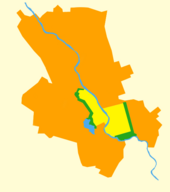
Hamilton Town Belt in green, original city size in yellow. HamiltonTownBelt.png
Hamilton Town Belt in green, original city size in yellow.

The Hamilton Town Belt, also known as the Green Belt, is a series of public parks in Hamilton, New Zealand that surround the original 1877 city boundaries. [1] Many of the cities notable venues and attractions are located on the belt, including Hamilton Gardens, Waikato Stadium, Seddon Park, Hamilton Girls' High School, Founders Theatre and the Hamilton Lake Domain.

Hamilton, New Zealand City in North Island, New Zealand

Hamilton is a city in the North Island of New Zealand. It is the seat and most populous city of the Waikato region, with a territorial population of 169,300, the country's fourth most-populous city. Encompassing a land area of about 110 km2 (42 sq mi) on the banks of the Waikato River, Hamilton is part of the wider Hamilton Urban Area, which also encompasses the nearby towns of Ngaruawahia, Te Awamutu and Cambridge.

New Zealand Country in Oceania

New Zealand is a sovereign island country in the southwestern Pacific Ocean. The country geographically comprises two main landmasses—the North Island, and the South Island —and around 600 smaller islands. New Zealand is situated some 2,000 kilometres (1,200 mi) east of Australia across the Tasman Sea and roughly 1,000 kilometres (600 mi) south of the Pacific island areas of New Caledonia, Fiji, and Tonga. Because of its remoteness, it was one of the last lands to be settled by humans. During its long period of isolation, New Zealand developed a distinct biodiversity of animal, fungal, and plant life. The country's varied topography and its sharp mountain peaks, such as the Southern Alps, owe much to the tectonic uplift of land and volcanic eruptions. New Zealand's capital city is Wellington, while its most populous city is Auckland.

Hamilton Gardens

Hamilton Gardens is a public garden park in the south of Hamilton owned and managed by Hamilton City Council in New Zealand. The 54-hectare park is based on the banks of the Waikato River and includes enclosed gardens, open lawns, a lake, a nursery, a convention centre and the Hamilton East Cemetery. It is the Waikato Region's most popular visitor attraction, attracting more than 1 million people and hosting more than 2,000 events a year.

The eastern section of the belt separates the suburbs of Hamilton East and Hillcrest.

Hamilton East, New Zealand

Hamilton East is a suburb in central Hamilton in New Zealand. The suburb's primary commercial and retail precinct is located along Grey Street. Hamilton East is characterised by villas and bungalows built early in the 20th century.

See also

Related Research Articles

Hillcrest, Hamilton

Hillcrest is a suburb in south-eastern Hamilton in New Zealand. The suburb is the home to the University of Waikato and consequently has a large student population. It is located on the east side of the Hamilton Town Belt, a series of public parks that run from the Hamilton Gardens to Ruakura in its eastern section.

Queenwood is a suburb in northern Hamilton in New Zealand. This place is separated by Chartwell Park from Chartwell. It is mostly a residential area, with the typical range of local shops. It is located between River Road and Hukanui Road.

Riverlea, New Zealand

Riverlea is a suburb in south-eastern Hamilton in New Zealand. It is located south of Hillcrest. The suburb is primarily residential, with a small section of light industrial land along Riverlea Road.

Crawshaw, New Zealand

Crawshaw is a suburb in western Hamilton in New Zealand.

Glenview, New Zealand human settlement in New Zealand

Glenview is a suburb in southern Hamilton in New Zealand. It was named by Bruce Lugton of developers Lugton Lands. He chose Glenview because he felt it depicted the area perfectly. It was defined as a suburb in 1963.

Grandview Heights, New Zealand human settlement in New Zealand

Grandview Heights is a suburb in western Hamilton in New Zealand.

Hamilton North is a suburb in central Hamilton in New Zealand. It was not depicted a suburb until there was a need to distinguish between the different parts of the Hamilton CBD. The suburbs of Hamilton Central and Hamilton North were divided in 1963.

Rotokauri

Rotokauri is a semi-rural suburb in western Hamilton in New Zealand. It is one of the future urban zones of Hamilton, along with Peacocke. The outskirts of Rotokauri have an impressive orchid farm, all under glass, exporting blooms across the world, and providing ample local employment.

Thornton is a suburb in western Hamilton in New Zealand.

Ashmore, New Zealand human settlement in New Zealand

Ashmore is a suburb in north-eastern Hamilton in New Zealand.

Callum Brae

Callum Brae is a suburb in north-eastern Hamilton in New Zealand.

Chedworth Park

Chedworth Park, also known simply as Chedworth, is a suburb in eastern Hamilton in New Zealand. It was defined as a suburb of Hamilton in 1974.

Harrowfield is a suburb in eastern Hamilton in New Zealand.

Magellan Rise (suburb) human settlement in New Zealand

Magellan Rise is a new suburb in north-eastern Hamilton in New Zealand.

Somerset Heights

Somerset Heights is a suburb in north-eastern Hamilton in New Zealand.

St James Park is a suburb in north-eastern Hamilton in New Zealand.

St Petersburg, New Zealand

St Petersburg is a suburb in north-eastern Hamilton in New Zealand.

Peacocke, New Zealand human settlement in New Zealand

Peacocke is a semi-rural suburb in southern Hamilton in New Zealand. Peacocke was brought into the city boundaries in 1989. It is one of the future urban zones of Hamilton, along with Rotokauri.

Whitiora

Whitiora is a suburb in central Hamilton in New Zealand. The suburb is home to Waikato Stadium, formerly Rugby Park. It is a major sporting and cultural events venue in Hamilton with a total capacity of 25,800. The stadium is a multi-purpose facility, though used mainly for rugby union.

Huntington is a suburb in north-eastern Hamilton in New Zealand.

References

  1. Westwood, L.G. (1962). Hamilton City — Its Establishment and Development.

Coordinates: 37°47′41.27″S175°18′30.27″E / 37.7947972°S 175.3084083°E / -37.7947972; 175.3084083

Geographic coordinate system Coordinate system

A geographic coordinate system is a coordinate system that enables every location on Earth to be specified by a set of numbers, letters or symbols. The coordinates are often chosen such that one of the numbers represents a vertical position and two or three of the numbers represent a horizontal position; alternatively, a geographic position may be expressed in a combined three-dimensional Cartesian vector. A common choice of coordinates is latitude, longitude and elevation. To specify a location on a plane requires a map projection.